When we think of Nepal, we tend to think of the snow-capped mountains of the Himalayas, the crystal-clear still waters of its alpine lakes, or the huge expanse of its grasslands. What some of us may not realize is that in the Himalayan foothills, where the climate is much warmer and the landscape much greener, there lives a great diversity of wildlife, including the one-horned rhinoceros, the Asian elephant and the Bengal tiger. But unfortunately, these animals are under constant threat from poachers who hunt and kill them for their body parts. To stop the killing of these animals, battalions of soldiers and rangers are sent to protect Nepal's national parks, but that is not an easy task, because these soldiers have to patrol thousands of hectares of forests on foot or elephant backs. It is also risky for these soldiers when they get into gunfights with poachers, and therefore Nepal is always looking for new ways to help with protecting the forests and wildlife.
當我們想到尼泊爾 我們很容易想到積雪蓋頂的 喜馬拉雅山脈 清澈如水晶的平靜高山湖水 或是綿延不盡的大草原 我們可能沒有意識到的是 在喜馬拉雅山腳 氣候更溫暖 景色更青翠的地方 住著種類繁多的野生動物 包括印度犀牛 亞洲象 及孟加拉虎 但不幸的是,這些動物 不斷受到盜獵者威脅 這些人獵殺這些動物 只為了他們的身體的某部分 為了要停止殺戮這些動物 一隊隊的軍人及管理員 被送去保護尼泊爾的國家公園 但那不是件輕鬆的工作 因為這些軍人必須巡守 數千公頃的森林,或徒步 或騎乘大象 對這些軍人而言 當他們與盜獵者槍戰時風險也很高 因此尼泊爾總是在找 新的方法來幫助保護森林 及野生動物
Well recently, Nepal acquired a new tool in the fight against wildlife crime, and these are drones, or more specifically, conservation drones. For about a year now, my colleagues and I have been building drones for Nepal and training the park protection personnel on the use of these drones. Not only does a drone give you a bird's-eye view of the landscape, but it also allows you to capture detailed, high-resolution images of objects on the ground. This, for example, is a pair of rhinoceros taking a cooling bath on a hot summer day in the lowlands of Nepal. Now we believe that drones have tremendous potential, not only for combating wildlife crime, but also for monitoring the health of these wildlife populations.
最近,尼泊爾取得一種新的工具 來對抗打擊野生動物犯罪 而這些工具就是無人駕駛飛機 或更精確地說,保育型無人機 大約有一年了,我的同事及我 為尼泊爾打造數架無人機 並訓練公園保護人員 如何使用這些無人機 無人機不僅給你 地形的鳥瞰圖 同時也讓你拍攝詳細 高解析度的地面物體圖像 這個,舉例來說,是一對犀牛 在炎夏的某天 在尼泊爾的低地泡冷水澡 現在我們相信無人機 有非常大的潛力 不只能對抗打擊野生動物犯罪 同時也能監測 這些野生動物族群的健康狀況
So what is a drone? Well, the kind of drone I'm talking about is simply a model aircraft fitted with an autopilot system, and this autopilot unit contains a tiny computer, a GPS, a compass, a barometric altimeter and a few other sensors. Now a drone like this is meant to carry a useful payload, such as a video camera or a photographic camera. It also requires a software that allows the user to program a mission, to tell the drone where to go.
所以什麼是無人機? 嗯,我所說的這種無人機 是非常簡單的一種模型飛機 配備自動駕駛系統 而這套自動駕駛系統 包含一個小電腦 一個衛星導航系統,一個羅盤 一個氣壓高度計 及幾個別種的偵測感應器 那麼像這樣的無人機 還必須有一定程度的有效載荷 譬如要能載一台攝影機 或是一台相機 它也需要一套軟體讓使用者 設計任務程式 告訴這架無人機飛到哪
Now people I talk to are often surprised when they hear that these are the only four components that make a conservation drone, but they are even more surprised when I tell them how affordable these components are. The facts is, a conservation drone doesn't cost very much more than a good laptop computer or a decent pair of binoculars.
現在聽到我解說的人通常都很驚訝 當他們聽到只要 這四個組成分 就能組成一架保育無人機 但他們通常更驚訝於 當我告訴他們這些組成份有多平價 事實是一架保育型無人機 不會比 一台好的筆電 或一組像樣的雙筒望遠鏡貴多少
So now that you've built your own conservation drone, you probably want to go fly it, but how does one fly a drone? Well, actually, you don't, because the drone flies itself. All you have to do is to program a mission to tell the drone where to fly. But you simply do that by clicking on a few way points on the Google Maps interface using the open-source software. Those missions could be as simple as just a few way points, or they could be slightly longer and more complicated, to fly along a river system. Sometimes, we fly the drone in a lawnmower-type pattern and take pictures of that area, and those pictures can be processed to produce a map of that forest. Other researchers might want to fly the drone along the boundaries of a forest to watch out for poachers or people who might be trying to enter the forest illegally.
所以現在你已經造了一架 自己的保育型無人機 你大概會想去駕駛它 但要怎麼駕駛一架無人機? 嗯,其實你不需要 因為這架無人機能自己飛 你所要做的就是設計一個任務 告訴無人機飛去哪 但你只需要點擊 Google 地圖介面上的幾個航點 以開放原始碼軟體來做 這些任務可以簡單到 僅由幾個航點組成 或也可以稍微長一點更複雜一點 譬如沿著一條河系飛 有時候我們以割草機模式飛無人機 並且拍攝那片區域的相片 而這些相片可再處理 以製作那片森林的地圖 其它的研究員或許想讓無人機 沿著一片森林的邊際飛 以觀察注意盜獵者或其他 想試著非法進入這片森林的人
Now whatever your mission is, once you've programmed it, you simply upload it to the autopilot system, bring your drone to the field, and launch it simply by tossing it in the air. And often we'll go about this mission taking pictures or videos along the way, and usually at that point, we will go grab ourselves a cup of coffee, sit back, and relax for the next few minutes, although some of us sit back and panic for the next few minutes worrying that the drone will not return. Usually it does, and when it does, it even lands automatically.
現在不管你的任務是什麼 一但你寫好程式 你就只要上傳到那套自動飛航系統 把你的無人機運到田野 然後就把它丟到空中啟動它 而且我們常常會 在任務中拍照或拍影片 所以在啟動之後 我們會去給自己拿杯咖啡 坐下來,休息個幾分鐘 雖然有些人會在坐下後 恐慌個幾分鐘 擔心這無人機飛不回來 通常它都會飛回來,而且當它飛回來時 它甚至還能自動降落
So what can we do with a conservation drone? Well, when we built our first prototype drone, our main objective was to fly it over a remote rainforest in North Sumatra, Indonesia, to look for the nest of a species of great ape known as the orangutan. The reason we wanted to do that was because we needed to know how many individuals of this species are still left in that forest. Now the traditional method of surveying for orangutans is to walk the forest on foot carrying heavy equipment and to use a pair of binoculars to look up in the treetops where you might find an orangutan or its nest. Now as you can imagine, that is a very time-consuming, labor-intensive, and costly process, so we were hoping that drones could significantly reduce the cost of surveying for orangutan populations in Indonesia and elsewhere in Southeast Asia. So we were very excited when we captured our first pair of orangutan nests on camera. And this is it; this is the first ever picture of orangutan nests taken with a drone. Since then we have taken pictures of dozens of these nests from around various parts of Southeast Asia, and we're now working with computer scientists to develop algorithms that can automatically count the number of nests from the thousands of photos we've collected so far.
所以我們能拿一架 保育型無人機做什麼用? 嗯,當我們造出第一架原型無人機時 我們的主要目標是要能飛越 印尼北蘇門答臘一片偏遠的雨林 去找一種巨猿物種的巢穴 稱為紅毛猩猩 我們想要做這個的原因是 我們必須知道有多少 這種物種的個體還留在那片森林裡 那麼傳統的方法 調查紅毛猩猩,都是徒步走在森林裡 背着笨重的器材 並用雙筒望遠鏡在樹梢尋找 你很可能在樹梢找到一隻猩猩或其巢穴 你可以想像的到 那是個非常費時費力 又昂貴的方法 所以我們其實是希望無人機 能顯著的減少其成本 於調查在印尼的紅毛猩猩 及東南亞其他地方的數量 所以我們非常激動,當我們 以攝影機拍到我們第一對紅毛猩猩巢穴 就是這個;這就是有史以來第一張相片 以無人機拍到的紅毛猩猩巢穴 從那時起我們又拍了 數打的這種巢穴的照片 是從東南亞不同區域拍的 現在我們與電腦科學家合作 寫程式以自動計算 巢穴的數量,從成千上萬 我們收集到的照片中計算
But nests are not the only objects these drones can detect. This is a wild orangutan happily feeding on top of a palm tree, seemingly oblivious to our drone that was flying overhead, not once but several times. We've also taken pictures of other animals including forest buffalos in Gabon, elephants, and even turtle nests.
但巢穴並不是唯一 無人機能偵測到的物體 這是隻野生紅毛猩猩 在一棵棕櫚樹上餵奶 幾乎無視我們的無人機從頭上飛過 不止一次,很多次 我們還拍了其它動物的相片 包括加彭國的非洲紅水牛 大象甚至是烏龜巢
But besides taking pictures of just the animals themselves, we also take pictures of the habitats these animals live in, because we want to keep track of the health of these habitats. Sometimes, we zoom out a little and look at other things that might be happening in the landscape. This is an oil palm plantation in Sumatra. Now oil palm is a major driver of deforestation in that part of the world, so we wanted to use this new drone technology to keep track of the spread of these plantations in Southeast Asia. But drones could also be used to keep track of illegal logging activities. This is a recently logged forest, again in Sumatra. You could even still see the processed wooden planks left on the ground.
但除了拍攝動物本身的相片 我們還拍了這些動物的棲地 因為我們想追蹤 這些棲地的健康狀況 有時候我們縮小鏡頭一點點 看看其他還有可能發生 在這片大地上的事 這是一座位於蘇門答臘上的油棕樹園 現在油棕樹是森林砍伐的主要元兇 在世界的那塊區域 所以我們想要使用 這種新的無人機技術 以追蹤這種農園 在東南亞的傳播速度 但無人機也能拿來追蹤 非法伐木活動 這是最近才被砍伐的森林 還是在蘇門答臘 你甚至還能看見處理過的 木板留在地上
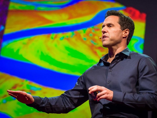
But perhaps the most exciting part about taking pictures from the air is we could later stitch these pictures together using special software to create a map of the entire landscape, and this map gives us crucial information for monitoring land use change, to let us know where and when plantations might be expanding, where forests might be contracting, or where fires might be breaking out. Aerial images could also be processed to produce three-dimensional computer models of forests. Now these models are not just visually appealing, but they are also geometrically accurate, which means researchers can now measure the distance between trees, calculate surface area, the volume of vegetation, and so on, all of which are important information for monitoring the health of these forests. Recently, we've also begun experimenting with thermal imaging cameras. Now these cameras can detect heat-emitting objects from the ground, and therefore they are very useful for detecting poachers or their campfires at night.
但或許最令人興奮的部分 與空拍有關的是 我們可以在之後把這些照片接起來 用特別的軟體來製造一幅地圖 是整個地面景觀的,而這張地圖 給我們重要的資訊 來監測土地使用的變遷 讓我們知道在何處何時農園可能擴張 哪裡的森林可能因此縮小 或哪裡可能有火燒森林的情況 空拍圖也能被再處理 以製造三度空間 電腦模擬的森林 現在這些模擬不只是視覺好看而已 他們在幾何上也很正確 也就是說研究員現在能測量 樹與樹間的距離 計算表面積,植被的體積 等等,所有這些都是重要的資料 用以監測這些森林的健康狀態 最近,我們也開始實驗 使用熱像儀 現在這些攝像機能偵測 在地面放熱的物體 因此這些相機對偵測盜獵者 或是他們夜間生的營火非常有用
So I've told you quite a lot about what conservation drones are, how you might operate one of these drones, and what a drone could do for you. I will now tell you where conservation drones are being used around the world. We built our first prototype drones in Switzerland. We brought a few of these to Indonesia for the first few test flights. Since then, we've been building drones for our collaborators from around the world, and these include fellow biologists and partners from major conservation organizations.
所以我已經告訴你不少關於 什麼是保育型無人機 你可以如何操作一架這種無人機 及無人機能為你做些什麼 我現在還要告訴你保育型無人機 可在全世界的那裡被使用 我們在瑞士造了第一批無人機的原型機 我們拿了幾個到印尼 來做首次的幾個試飛 從那時起,我們又造了無人機 給我們在全世界的合作單位 而這些單位包括了幾位資深生物學家 及主要保育機構的幾位合夥人
Perhaps the best and most rewarding part about working with these collaborators is the feedback they give us on how to improve our drones. Building drones for us is a constant work in progress. We are constantly trying to improve them in terms of their range, their ruggedness, and the amount of payload they can carry. We also work with collaborators to discover new ways of using these drones. For example, camera traps are a common tool used by biologists to take pictures of shy animals hiding in the forests, but these are motion-activated cameras, so they snap a picture every time an animal crosses their path. But the problem with camera traps is that the researcher has to go back to the forest every so often to retrieve those images, and that takes a lot of time, especially if there are dozens or hundreds of these cameras placed in the forest. Now a drone could be designed to perform the task much more efficiently. This drone, carrying a special sensor, could be flown over the forest and remotely download these images from wi-fi–enabled cameras.
或許最棒及最有成就感的部分 在與這些合作者共事之處 就是他們給予我們的回饋意見 該如何改善我們的無人機 對我們而言造無人機是 持續不斷的工作 我們不斷地嘗試改善它們,無論在 它們的航程,它們的耐用性 及它們能承載的有效載荷量都有 我們也與合作者共事 開發新方法使用這些無人機 舉個例,相機陷阱是常見的工具 被生物學家拿來捕捉害羞的動物 藏在森林裡的照片 但這些是以動作感應觸發快門的相機 所以每次一有動物穿越路徑 就會拍下一張照片 但相機陷阱的問題 是研究員必須每隔一段時間 就回到森林拿回相片 而這很費時 特別是如果有上打 或上百的這種相機放在森林裡 現在一架無人機可以設計來做這個工作 效率就好多了 這種無人機,載著一個特別的感應器 可以飛越森林 且遙控下載這些相片 從可以無線上網的相機傳送
Radio collars are another tool that's commonly used by biologists. Now these collars are put onto animals. They transmit a radio signal which allows the researcher to track the movements of these animals across the landscape. But the traditional way of tracking animals is pretty ridiculous, because it requires the researcher to be walking on the ground carrying a huge and cumbersome radio antenna, not unlike those old TV antennae we used to have on our rooftops. Some of us still do. A drone could be used to do the same job much more efficiently. Why not equip a drone with a scanning radio receiver, fly that over the forest canopy in a certain pattern which would allow the user or the operator to triangulate the location of these radio-collared animals remotely without having to step foot in the forest.
無線電追蹤項圈是另一種 常被生物學家使用的工具 那麼這些項圈被套在動物上 它們傳輸一種無線電信號 讓研究者追蹤這些動物在大地上的移動 但這種傳統的追蹤動物法 還挺好笑的 因為這需要研究員在 地上走來走去背着一個 巨大又笨重的無線電天線 就像我們以前用的那些 老式的電視天線一樣 架在屋頂上那種。我們中間應該還有人用 一架無人機可以拿來做同樣的事 還更有效率 為什麼不在一架無人機上 裝上掃描無線電接收器 飛越整片林冠 以特別的飛行模式 能讓使用者或操縱者 以三角測量法遙控測出 這些帶著無線電項圈的動物 而無需實際進入森林
A third and perhaps most exciting way of using these drones is to fly them to a really remote, never-explored-before rainforest somewhere hidden in the tropics, and parachute down a tiny spy microphone that would allow us to eavesdrop on the calls of mammals, birds, amphibians, the Yeti, the Sasquatch, Bigfoot, whatever. That would give us biologists a pretty good idea of what animals might be living in those forests.
第三種也可能是最令人振奮的 無人機使用方法 就是把它們飛到一個真正偏僻 從未被人探險過的雨林 那些藏在熱帶地區的秘境 然後以降落傘降下一個 很小的間諜麥克風 能讓我們竊聽 哺乳動物、鳥類及兩棲類的叫聲 還有雪怪、野人、大腳怪,什麼都可以 那將給我們這些生物學者 一個起碼的概念有什麼動物 可能住在那些森林裡
And finally, I would like to show you the latest version of our conservation drone. The MAJA drone has a wingspan of about two meters. It weighs only about two kilograms, but it can carry half its weight. It is a fully autonomous system. During its mission, it can even transmit a live video feed back to a ground station laptop, which allows the user to see what the drone is seeing in real time. It carries a variety of sensors, and the photo quality of some of these sensors can be as high as one to two centimeters per pixel. This drone can stay in the air for 40 to 60 minutes, which gives it a range of up to 50 kilometers. That is quite sufficient for most of our conservation applications.
而最後,我想給各位看 我們最新款的保育型無人機 這款 MAJA 無人機有 大約兩公尺的翼展 重量僅約兩公斤 但它可以承載其一半重量 它是全自治系統 在任務中,它可以傳輸 現場直播的影像回去地面站的筆電 這樣能讓使用者 即時看到無人機所看到的東西 它也攜帶各式感應器 而其中一些感應器的相片畫質 可高達每像素一至二公分 這個無人機可以 在空中飛行 40 到 60 分鐘 這可使航程達到 50 公里 這對大部分 保育行動都很夠用
Now, conservation drones began as a crazy idea from two biologists who are just deeply passionate about this technology. And we believe, strongly believe, that drones can and will be a game changer for conservation research and applications. We've had our fair share of skeptics and critics who thought that we were just fooling around with toy planes. And in a way, they are right. I mean, let's be honest, drones are the ultimate toys for boys. But at the same time, we've also gotten to know many wonderful colleagues and collaborators who share our vision and see the potential of conservation drones. To us, it is obvious that conservation biologists and practitioners should make full use of every available tool, including drones, in our fight to save the last remaining forests and wildlife of this planet.
那麼,保育型無人機從 兩個生物學家的瘋狂點子開始 他們只是深深熱愛著這項科技 而我們相信,強烈地相信 無人機可以,並將成為 改變遊戲規則的器具 以用在保育研究及應用上 我們已經得到太多的懷疑及批評 他們認為我們只是 把弄著玩具飛機鬼混 從某種程度上看,他們是對的 我的意思是,說實話 無人機的確是男孩們的終極玩具 但同時我們也必須瞭解 許多優秀的同事及合作者 與我們同享願景 並看到保育型無人機的潛能 對我們而言,毫無疑問地,生態保育學家 及從事這行的人都應該充分利用 手邊可用的每一項工具,包括無人機 在我們拯救這星球上最後僅存的森林 及野生動物的奮鬥中
Thank you.
謝謝
(Applause)
(掌聲)