When we think of Nepal, we tend to think of the snow-capped mountains of the Himalayas, the crystal-clear still waters of its alpine lakes, or the huge expanse of its grasslands. What some of us may not realize is that in the Himalayan foothills, where the climate is much warmer and the landscape much greener, there lives a great diversity of wildlife, including the one-horned rhinoceros, the Asian elephant and the Bengal tiger. But unfortunately, these animals are under constant threat from poachers who hunt and kill them for their body parts. To stop the killing of these animals, battalions of soldiers and rangers are sent to protect Nepal's national parks, but that is not an easy task, because these soldiers have to patrol thousands of hectares of forests on foot or elephant backs. It is also risky for these soldiers when they get into gunfights with poachers, and therefore Nepal is always looking for new ways to help with protecting the forests and wildlife.
Когда мы думаем о Непале, мы представляем себе заснеженные вершины Гималаев, кристально-чистые альпийские озёра или бескрайние просторы лугов. Но далеко не каждый осознаёт, что в предгорьях Гималаев, где климат намного мягче, а зелени гораздо больше, дикая природа очень разнообразна: здесь обитает однорогий носорог, азиатский слон и бенгальский тигр. К сожалению, этим животным постоянно угрожают браконьеры, которые охотятся на них и убивают с целью наживы. Чтобы прекратить убийства животных, отряды солдат и лесников постоянно отправляются на защиту национальных парков Непала. Но это не так просто, потому что им приходиться патрулировать тысячи гектаров леса пешком или верхом на слонах. Кроме того, солдаты постоянно рискуют жизнью, попадая в перестрелки с браконьерами, поэтому Непал постоянно ищет новые пути для защиты лесов и дикой природы.
Well recently, Nepal acquired a new tool in the fight against wildlife crime, and these are drones, or more specifically, conservation drones. For about a year now, my colleagues and I have been building drones for Nepal and training the park protection personnel on the use of these drones. Not only does a drone give you a bird's-eye view of the landscape, but it also allows you to capture detailed, high-resolution images of objects on the ground. This, for example, is a pair of rhinoceros taking a cooling bath on a hot summer day in the lowlands of Nepal. Now we believe that drones have tremendous potential, not only for combating wildlife crime, but also for monitoring the health of these wildlife populations.
Недавно Непал приобрёл новый инструмент для борьбы с преступлениями против живой природы – беспилотники, а именно, природоохранные беспилотники. Почти целый год я и мои коллеги строим эти беспилотники для Непала и обучаем персонал охраны парка пользоваться ими. Беспилотники позволяют не только рассмотреть всё с высоты птичьего полёта, но также фиксировать детальное изображение объектов на земле в широком разрешении. Вот, например, пара носорогов, принимающих водные процедуры в жаркий летний день в низинах Непала. Мы считаем, что беспилотники обладают огромным потенциалом не только в борьбе с преступлениями в отношении дикой природы, но и при контроле за здоровьем популяций диких животных.
So what is a drone? Well, the kind of drone I'm talking about is simply a model aircraft fitted with an autopilot system, and this autopilot unit contains a tiny computer, a GPS, a compass, a barometric altimeter and a few other sensors. Now a drone like this is meant to carry a useful payload, such as a video camera or a photographic camera. It also requires a software that allows the user to program a mission, to tell the drone where to go.
Итак, что такое беспилотник? Беспилотник, о котором говорю я, – простая модель самолёта, оснащённая автопилотом. Этот автопилот содержит маленький компьютер, GPS-навигатор, компас, барометрический альтиметр и другие датчики. Подобные беспилотники используются для перевозки полезной техники, такой, как видеокамера или фотокамера. Кроме того, необходимо программное обеспечение, позволяющее пользователю программировать полёт, задавая беспилотнику направление.
Now people I talk to are often surprised when they hear that these are the only four components that make a conservation drone, but they are even more surprised when I tell them how affordable these components are. The facts is, a conservation drone doesn't cost very much more than a good laptop computer or a decent pair of binoculars.
Люди, с которыми я разговариваю, часто удивляются, что необходимо только четыре компонента, чтобы собрать природоохранный беспилотник; а ещё больше они удивляются, когда я говорю им, насколько эти компоненты доступны. Факт: природоохранный беспилотник стоит примерно столько же, сколько хороший ноутбук или приличный бинокль.
So now that you've built your own conservation drone, you probably want to go fly it, but how does one fly a drone? Well, actually, you don't, because the drone flies itself. All you have to do is to program a mission to tell the drone where to fly. But you simply do that by clicking on a few way points on the Google Maps interface using the open-source software. Those missions could be as simple as just a few way points, or they could be slightly longer and more complicated, to fly along a river system. Sometimes, we fly the drone in a lawnmower-type pattern and take pictures of that area, and those pictures can be processed to produce a map of that forest. Other researchers might want to fly the drone along the boundaries of a forest to watch out for poachers or people who might be trying to enter the forest illegally.
Когда вы собрали собственный природоохранный беспилотник, вам, вероятно, захочется отправить его летать. Но как его пилотировать? Вообще-то, никак. Беспилотник управляет собой сам. Всё, что вам надо сделать, – запрограммировать полёт, задавая беспилотнику направление. Вы просто задаёте координаты на карте Google Maps, используя бесплатное программное обеспечение. Такие полёты могут быть простыми – всего несколько маршрутных координат – или же более протяжёнными и сложными, например, полёт вдоль речной системы. Иногда мы программируем беспилотник так, чтобы он двигался, как газонокосилка, и делал фотографии местности. Такие фотографии обрабатываются для создания карты леса. Другие исследователи используют беспилотники для полётов вдоль границ леса, чтобы наблюдать за браконьерами и людьми, пытающимися незаконно проникнуть в лес.
Now whatever your mission is, once you've programmed it, you simply upload it to the autopilot system, bring your drone to the field, and launch it simply by tossing it in the air. And often we'll go about this mission taking pictures or videos along the way, and usually at that point, we will go grab ourselves a cup of coffee, sit back, and relax for the next few minutes, although some of us sit back and panic for the next few minutes worrying that the drone will not return. Usually it does, and when it does, it even lands automatically.
Какой бы ни была поставленная задача, как только вы её запрограммировали, вы загружаете её в автопилот, берёте беспилотник с собой в поле и запускаете его, просто подбрасывая в воздух. Мы часто начинаем очередной полёт по пути, делая снимки и снимая видео. Обычно в какой-то момент мы берём по чашке кофе, садимся и расслабляемся на несколько минут, в том время как другие начинают паниковать, беспокоясь, что беспилотник не вернётся. Обычно он всё же возвращается и даже приземляется автоматически.
So what can we do with a conservation drone? Well, when we built our first prototype drone, our main objective was to fly it over a remote rainforest in North Sumatra, Indonesia, to look for the nest of a species of great ape known as the orangutan. The reason we wanted to do that was because we needed to know how many individuals of this species are still left in that forest. Now the traditional method of surveying for orangutans is to walk the forest on foot carrying heavy equipment and to use a pair of binoculars to look up in the treetops where you might find an orangutan or its nest. Now as you can imagine, that is a very time-consuming, labor-intensive, and costly process, so we were hoping that drones could significantly reduce the cost of surveying for orangutan populations in Indonesia and elsewhere in Southeast Asia. So we were very excited when we captured our first pair of orangutan nests on camera. And this is it; this is the first ever picture of orangutan nests taken with a drone. Since then we have taken pictures of dozens of these nests from around various parts of Southeast Asia, and we're now working with computer scientists to develop algorithms that can automatically count the number of nests from the thousands of photos we've collected so far.
Что можно делать с природоохранным беспилотником? Когда мы собрали первый прототип беспилотника, нашей главной целью были полёты над удалёнными лесами Северной Суматры в Индонезии в поисках жилища человекообразной обезьяны, известной как орангутан. Мы делали это для того, чтобы узнать, сколько особей этого вида всё ещё обитает в этих лесах. Традиционный метод наблюдения за орангутанами – обход леса пешком, таща тяжёлое оборудование и используя бинокли, чтобы рассматривать верхушки деревьев, где можно обнаружить орангутана или его жилище. Как вы можете представить, это очень кропотливый, трудоёмкий и дорогостоящий процесс. Мы надеялись, что беспилотники смогут значительно снизить затраты на съёмки популяций орангутанов в Индонезии и в других регионах Юго-Восточной Азии. Мы были очень рады, когда засняли первые жилища орангутанов на камеру. Вот они. Это самая первая фотография жилищ орангутанов, снятая с помощью беспилотника. С тех пор мы сняли десятки подобных жилищ в различных районах Юго-Восточной Азии. Сейчас мы работаем с программистами, разрабатывая алгоритм, который будет автоматически считать количество жилищ на тысячах фотографий, которые мы уже собрали.
But nests are not the only objects these drones can detect. This is a wild orangutan happily feeding on top of a palm tree, seemingly oblivious to our drone that was flying overhead, not once but several times. We've also taken pictures of other animals including forest buffalos in Gabon, elephants, and even turtle nests.
Но жилища не единственные объекты, которые могут обнаружить беспилотники. Это дикий орангутан, самозабвенно поедающий что-то на верхушке пальмы, казалось бы, совершенно не обращая внимания на беспилотник, пролетевший мимо него несколько раз. Мы также сделали снимки других животных, в том числе лесного буйвола в Габоне, слонов и даже черепашьих гнёзд.
But besides taking pictures of just the animals themselves, we also take pictures of the habitats these animals live in, because we want to keep track of the health of these habitats. Sometimes, we zoom out a little and look at other things that might be happening in the landscape. This is an oil palm plantation in Sumatra. Now oil palm is a major driver of deforestation in that part of the world, so we wanted to use this new drone technology to keep track of the spread of these plantations in Southeast Asia. But drones could also be used to keep track of illegal logging activities. This is a recently logged forest, again in Sumatra. You could even still see the processed wooden planks left on the ground.
Кроме съёмок животных как таковых, мы также снимаем среду их обитания, чтобы отследить происходящие в ней изменения. Иногда мы немного уменьшаем масштаб и рассматриваем вещи, которые могут происходить на местности. Это плантация масличных пальм на Суматре. Добыча пальмового масла — одна из основных причин вырубки леса в этих районах, поэтому мы использовали беспилотники для отслеживания распространения этих плантаций в Юго-Восточной Азии. Беспилотники можно использовать и для контроля незаконной вырубки леса. Вот недавно вырубленный лес, снова на Суматре. Вы можете даже разглядеть использованные деревянные доски, оставленные на земле.
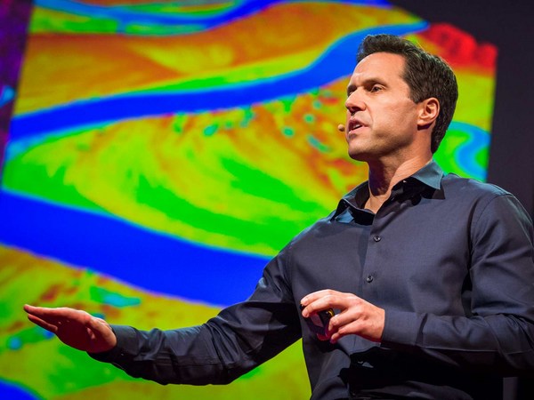
But perhaps the most exciting part about taking pictures from the air is we could later stitch these pictures together using special software to create a map of the entire landscape, and this map gives us crucial information for monitoring land use change, to let us know where and when plantations might be expanding, where forests might be contracting, or where fires might be breaking out. Aerial images could also be processed to produce three-dimensional computer models of forests. Now these models are not just visually appealing, but they are also geometrically accurate, which means researchers can now measure the distance between trees, calculate surface area, the volume of vegetation, and so on, all of which are important information for monitoring the health of these forests. Recently, we've also begun experimenting with thermal imaging cameras. Now these cameras can detect heat-emitting objects from the ground, and therefore they are very useful for detecting poachers or their campfires at night.
Но, пожалуй, самое захватывающее в съёмках с воздуха – возможность соединить все фотографии вместе, используя специальное программное обеспечение для создания полной карты местности. Такая карта даёт важнейшую информацию по контролю за использованием земли, чтобы мы знали, когда и где могут расшириться плантации, где могут сократиться леса или где могут возникнуть пожары. Также аэрофотоснимки могут быть обработаны для создания трёхмерной компьютерной модели лесов. Эти модели не только визуально приятны, но и геометрически точны. Это значит, что исследователи теперь могут измерять расстояние между деревьями, рассчитывать площадь поверхности, объём растительности и другую важную информацию для контроля за состоянием лесов. В последнее время мы начали использовать тепловизионные камеры. Эти камеры способны обнаружить тепловыделяющие объекты на земле. Они полезны для обнаружения браконьеров и их костров ночью.
So I've told you quite a lot about what conservation drones are, how you might operate one of these drones, and what a drone could do for you. I will now tell you where conservation drones are being used around the world. We built our first prototype drones in Switzerland. We brought a few of these to Indonesia for the first few test flights. Since then, we've been building drones for our collaborators from around the world, and these include fellow biologists and partners from major conservation organizations.
Я рассказал вам довольно много всего о природоохранных беспилотниках, как ими можно управлять и для чего они вообще нужны. А сейчас я расскажу, где природоохранные беспилотники используются во всем мире. Мы собрали первый прототип беспилотника в Швейцарии. Мы привезли несколько в Индонезию, чтобы совершить пару тестовых полётов. С тех пор мы собираем беспилотники для наших коллег по всему миру, включая биологов-любителей и партнёров из крупных природоохранных организаций.
Perhaps the best and most rewarding part about working with these collaborators is the feedback they give us on how to improve our drones. Building drones for us is a constant work in progress. We are constantly trying to improve them in terms of their range, their ruggedness, and the amount of payload they can carry. We also work with collaborators to discover new ways of using these drones. For example, camera traps are a common tool used by biologists to take pictures of shy animals hiding in the forests, but these are motion-activated cameras, so they snap a picture every time an animal crosses their path. But the problem with camera traps is that the researcher has to go back to the forest every so often to retrieve those images, and that takes a lot of time, especially if there are dozens or hundreds of these cameras placed in the forest. Now a drone could be designed to perform the task much more efficiently. This drone, carrying a special sensor, could be flown over the forest and remotely download these images from wi-fi–enabled cameras.
Пожалуй, самое лучшее и стоящее в работе с нашими коллегами – получаемая от них обратная связь о том, как можно улучшить наши беспилотники. Сборка беспилотников для нас – постоянная работа в развитии. Мы постоянно пытаемся улучшить такие параметры, как дальность полёта, прочность и полезная нагрузка. Мы также обращаемся к коллегам, чтобы выявить новые сферы использования беспилотников. Например, фотоловушки — очень распространённый инструмент, используемый биологами для съёмок пугливых животных, прячущихся в лесах. Эти камеры активируются при движении, поэтому они начинают съёмку каждый раз, когда животное появляется в кадре. Проблема фотоловушек в том, что исследователям приходится часто возвращаться в лес, чтобы забрать сделанные снимки, а это занимает много времени, особенно если десятки или сотни камер установлены по всему лесу. Беспилотник может выполнять эту работу куда более эффективно. Такой беспилотник, оснащённый специальным датчиком, может облетать лес и удалённо закачивать изображения с камер, поддерживающих Wi-Fi.
Radio collars are another tool that's commonly used by biologists. Now these collars are put onto animals. They transmit a radio signal which allows the researcher to track the movements of these animals across the landscape. But the traditional way of tracking animals is pretty ridiculous, because it requires the researcher to be walking on the ground carrying a huge and cumbersome radio antenna, not unlike those old TV antennae we used to have on our rooftops. Some of us still do. A drone could be used to do the same job much more efficiently. Why not equip a drone with a scanning radio receiver, fly that over the forest canopy in a certain pattern which would allow the user or the operator to triangulate the location of these radio-collared animals remotely without having to step foot in the forest.
Радио-ошейники также широко используются биологами. Эти ошейники одевают на животных. Они передают радиосигнал, который позволяет исследователям отслеживать перемещения животных по местности. Традиционный способ отслеживания животных достаточно нелепый, потому что исследователям приходится ходить пешком, таская с собой громоздкую радиоантенну, похожую на те старые ТВ-антенны, которые были у нас на крышах. А у кого-то они есть и до сих пор. Беспилотник может выполнять такую работу гораздо эффективнее. Почему бы не оборудовать беспилотник сканирующим радиоприёмником и не запустить его над кронами деревьев по определённому маршруту? Это позволит пользователю или оператору делать тригонометрическую съёмку местности, отслеживая животных с радио-ошейниками без неоходимости заходить в лес.
A third and perhaps most exciting way of using these drones is to fly them to a really remote, never-explored-before rainforest somewhere hidden in the tropics, and parachute down a tiny spy microphone that would allow us to eavesdrop on the calls of mammals, birds, amphibians, the Yeti, the Sasquatch, Bigfoot, whatever. That would give us biologists a pretty good idea of what animals might be living in those forests.
Третий и, пожалуй, самый захватывающий способ использования беспилотников – запускать их в действительно отдалённые, никогда ранее не исследованные дождевые леса, спрятанные где-то далеко в тропиках. С их помощью спускать малюсенький микрофон, который позволит подслушивать звуки млекопитающих, птиц, амфибий, Йети, снежного человека, Бигфута и кого угодно. Это даст биологам достаточно хорошее представление о том, каковы условия обитания животных в этих лесах.
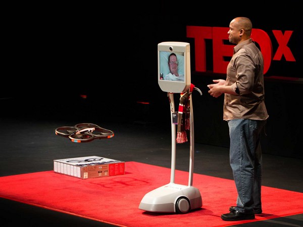
And finally, I would like to show you the latest version of our conservation drone. The MAJA drone has a wingspan of about two meters. It weighs only about two kilograms, but it can carry half its weight. It is a fully autonomous system. During its mission, it can even transmit a live video feed back to a ground station laptop, which allows the user to see what the drone is seeing in real time. It carries a variety of sensors, and the photo quality of some of these sensors can be as high as one to two centimeters per pixel. This drone can stay in the air for 40 to 60 minutes, which gives it a range of up to 50 kilometers. That is quite sufficient for most of our conservation applications.
Напоследок, мне бы хотелось показать вам последнюю модель природоохранного беспилотника. Размах крыльев беспилотника MAJA – около двух метров. Он весит около 2 килограммов, но может перевозить груз в половину своего веса. Это полностью автономная система. Во время полёта он даже может передавать «живое» видео на ноутбук наземной станции, что позволит пользователю наблюдать картинку в реальном времени. Он оснащён разнообразными датчиками, а высокое качество фотографий, сделанных с их помощью, может достигать 1-2 сантиметра на пиксель. Такой беспилотник может находиться в воздухе от 40 до 60 минут, что позволяет исследовать до 50 километров. Этого вполне достаточно для большинства природоохранных приложений.
Now, conservation drones began as a crazy idea from two biologists who are just deeply passionate about this technology. And we believe, strongly believe, that drones can and will be a game changer for conservation research and applications. We've had our fair share of skeptics and critics who thought that we were just fooling around with toy planes. And in a way, they are right. I mean, let's be honest, drones are the ultimate toys for boys. But at the same time, we've also gotten to know many wonderful colleagues and collaborators who share our vision and see the potential of conservation drones. To us, it is obvious that conservation biologists and practitioners should make full use of every available tool, including drones, in our fight to save the last remaining forests and wildlife of this planet.
Природоохранный беспилотник был безумной идеей двух биологов, невероятно воодушевлённых данной технологией. Мы верим, твёрдо верим, что беспилотники смогут изменить правила игры в исследованиях и приложениях по охране природы. Мы выслушивали скептиков и критиков, думающих, что мы просто дурачимся с игрушечными самолётиками. В каком-то смысле, они были правы. Точнее, если быть честными, беспилотники – потрясающие игрушки для мальчишек. Но в тоже время, нам удалось познакомиться со многими потрясающими людьми, которые разделяют наше видение и понимают потенциал природоохранных беспилотников. Для нас очевидно, что биологи по охране природы и специалисты должны в полной мере использовать каждый доступный инструмент, включая беспилотники, в борьбе за сохранение оставшихся лесов и фауны на нашей планете.
Thank you.
Спасибо.
(Applause)
(Аплодисменты)