About a year and a half ago, Stephen Lawler, who also gave a talk here at TED in 2007 on Virtual Earth, brought me over to become the architect of Bing Maps, which is Microsoft's online-mapping effort. In the past two and a half, we've been very hard at work on redefining the way maps work online. And we really are seeing this in very different terms from the kind of mapping and direction site that one is used to.
大約一年半前, Stephen Lawler 在 TED 2007 給了一個 關於虛擬地球的演講, 也是他使我成爲 Bing 地圖的程式設計師, Bing 地圖是微軟對於線上地圖的一次嘗試。 過去的兩年半中,我們工作得很努力, 我們試圖重新定義線上地圖是如何工作的。 我們是真正的將它當作一個完全不同的名詞來看待, 改變大家過去對於線上地圖只是 地圖和方向指引網頁的看法。
So, the first thing that you might notice about the mapping site is just the fluidity of the zooming and the panning, which, if you're familiar at all with Seadragon, that's where it comes from.
所以, 這個地圖網頁首先引起你注意的 是流暢的地圖縮放和平移, 如果你熟悉「海龍」(Seadragon) 技術, 這種流暢度就是來自於那個技術。
Mapping is, of course, not just about cartography, it's also about imagery. So, as we zoom-in beyond a certain level this resolves into a kind of Sim City-like virtual view at 45 degrees. This can be viewed from any of the cardinal directions to show you the 3D structure of the city, all the facades. Now, we see this space, this three-dimensional environment, as being a canvas on which all sorts of applications can play out, and map's directions are really just one of them.
當然,地圖並不僅僅 涉及製圖學, 它也包含影像。 所以當我們放大到一定的程度, 它就轉換成了類似遊戲《模擬城市》般 45 度角的虛擬視野。 你可以從任何角度來看它, 它從各個角度向人們展示了城市的立體結構。 現在, 我們看到這個空間,這個立體的環境, 作爲一塊畫布, 各式各樣的應用程式都可以在上面進行發揮, 而用地圖來指引方向,只是這些應用的其中之一。
If you click on this, you'll see some of the ones that we've put out, just in the past couple of months since we've launched. So, for example, a couple of days after the disaster in Haiti, we had an earthquake map that showed before and after pictures from the sky. This wonderful one which I don't have time to show you is taking hyper-local blogs in real time and mapping those stories, those entries to the places that are referred to on the blogs. It's wonderful.
如果你點擊這裡, 你可以看見,我們於過去幾個月中,從我們的地圖服務開放以來, 所推出的東西。 比如,在海地受災後的幾天內, 我們的地震地圖就顯示了 震災前後的空拍照片。 由於時間的關係,以下這個精彩的應用,我無法示範給你們看, 它能於第一時間,從該區域的部落格裡提取內容, 將部落格中提到的故事和記錄, 在地圖上標識出來。 這真的很棒!
But I'm going to show you some more candy sort of stuff.
然而,我要給你們看一些比較吸睛的東西。
So, we see the imagery, of course, not stopping at the sky. These little green bubbles represent photosynths that users have made. I'm not going to dive into them either, but photosynths are integrated into the map. Everything that's cased in blue is an area where we've taken imagery on the ground as well.
當然,我們看到圖資, 不僅僅是停留在空中的視角, 這些綠色的小泡泡代表了 用戶群的像片合成的結果, 關於像片合成 (photosynths) 以及其與地圖的整合,我也就不深入探究了, 所有的藍色地帶 都是我們在地面上拍過照的地方,
And so, when you fly down --
因此, 當你往下飛 —
(Applause)
(掌聲)
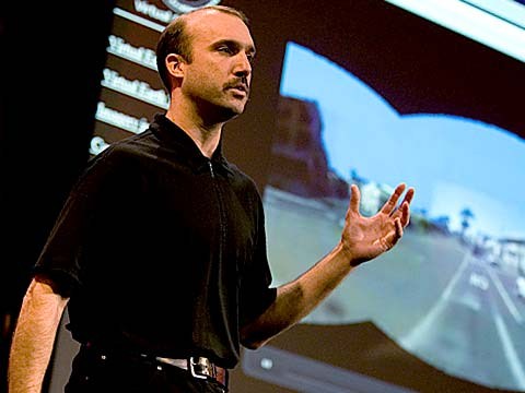
Thank you. When you fly down to the ground, and you see this kind of panoramic imagery, the first thing that you might notice is that it's not just a picture, there's just as much three-dimensional understanding of this environment as there is of the three-dimensional city from above, so if I click on something to get a closer view of it, then, the fact that that transition looks as it does, is a function of all of that geometry, all of that 3D understanding behind this model.
謝謝, 當你飛到地表的時候, 你便可以看見類似的全景圖像, 你第一個會注意到的是,這並不僅是一張照片, 它能了解這個立體的環境, 就跟從空中俯瞰的立體城市一樣, 所以當我點擊目標,靠近觀察, 事實上,你可看到那個轉換的過程, 都是這個地圖背後對於幾何 以及立體環境的了解在發生作用。
Now, I'll show you a fun app that -- we've been working on a collaboration with our friends at Flickr. This takes Flickr, georegistered imagery and uses photosynth-like processes to connect that imagery to our imagery, so -- I'm not sure if that's the one I actually meant to pull up, but --
現在,我要爲你們示範一個有趣的程式, 這是我們協同在 Flicker 的朋友一起開發的。 這個程式將 Flickr 裡有地理位置標籤的圖資, 使用類似「像片合成」的程序, 將那些圖資跟我們的圖資連結。 我不確定這是我想要找的東西,
(Laughter)
(笑聲)
But notice -- this is, of course, a popular tourist site, and there are lots of photos around here, and these photos are all taken at different times. So this one was taken around five. So that's the Flickr photo, that's our imagery. So you really see how this kind of crowd-sourced imagery is integrating, in a very deep way, into the map itself.
但是,你們可以看到, 這是一個熱門的觀光景點, 這附近有很多照片, 這些照片是於不同時間拍的, 這張是早上 5 點拍的, 那是 Flickr 的照片, 這是我們的照片。 這樣你可以知道,這種由網路社群提供的圖資 是如何深層的與地圖本身整合在一起。
(Applause)
(掌聲)
Thank you.
謝謝。
(Applause)
(掌聲)
There are several reasons why this is interesting and one of them, of course, is time travel. And I'm not going to show you some of the wonderful historic imagery in here, but there are some with horses and carriages and so on as well. But what's cool about this is that, not only is it augmenting this visual representation of the world with things that are coming in from users, but it also is the foundation for augmented reality, and that's something that I'll be showing you more of in just a moment.
這之所以很有趣,有幾個原因 其中之一,當然,是時光旅行, 我就不示範這些精彩的歷史圖資了, 但是在那些圖資裡面有馬車之類的東西。 這之所以很酷, 並不僅僅是因爲 它從使用者身上蒐集了取多東西, 並以之充實了對大千世界的視覺呈現。 但同時, 這也是增強實境的基礎, 過一會兒,我將更詳細地向你們介紹這項功能,
Now I just made a transition indoors. That's also interesting. OK, notice there's now a roof above us. We're inside the Pike Place Market. And this is something that we're able to do with a backpack camera, so, we're now not only imaging in the street with this camera on tops of cars, but we're also imaging inside. And from here, we're able to do the same sorts of registration, not only of still images, but also of video.
現在我,正在轉換進入室內,這也很有趣, 請注意,現在有屋頂在我們的頭上方了。 我們現在是在派克市場裡面, 這些圖資是我們使用背負式攝影機所拍攝的。 所以, 我們不光是在街上 使用架設在汽車頂上的攝影機拍攝圖資, 我們同時也在室內拍攝。 從這裡, 我們可以使用各種東西來成像, 不只是用靜態的圖片,也可以用影片。
So this is something that we're now going to try for the first time, live, and this is really, truly, very frightening.
我們現在就來試驗一下, 這是我們第一次做直播測試。 這真是,真的,非常可怕。
(Laughter)
(笑聲)
OK.
好
(Ringing)
(電話鈴聲)
All right, guys, are you there?
好了,夥計們, 你們在嗎?
(Noise)
(噪音)
All right. I'm hitting it. I'm punching play. I'm live. All right. There we go. So, these are our friends in Pike Place Market, the lab.
好,我上線了,正式開始。 直播開始了,好的,開始。 這是我們現在正位於派克市場的朋友們,我們實驗室的成員。
(Applause)
(掌聲)
So they're broadcasting this live. OK, George, can you pan back over to the corner market? Because I want to show points of interest. No, no. The other way. Yeah, yeah, back to the corner, back to the corner. I don't want to see you guys yet. OK, OK, back to the corner, back to the corner, back to the corner. OK, never mind.
他們現在在現場直播。 好吧,喬治,你能把鏡頭移到市場的角落嗎? 因爲我想示範一下資訊熱點功能。 不,不,另外一個方向。 對了,對了,回到角落,回到角落 我還不想看見你們呢。 好吧,好吧,回到角落,回到角落,回到角落。 好吧, 算了。
What I wanted to show you was these points of interest over here on top of the image because what that gives you a sense of is the way, if you're actually on the spot, you can think about this -- this is taking a step in addition to augmented reality.
我本來想要示範給你們看的是這些資訊熱點 會層疊在這個圖資上方。 因爲這會讓你感覺, 彷彿身歷其境 ... 你可以這樣想: 這是在增強實境的基礎上又邁進了一步,
What the hell are you guys -- oh, sorry.
你們這些傢伙在幹什麼啊?噢,對不起
(Laughter)
(笑聲)
We're doing two different -- OK, I'm hanging up now. We're doing two different things here. One of them is to take that real ...
我們正在做兩件不同的事情, 好吧,我要掛了。 我們正在做兩件不一樣的事情, 他們中的一個正要去拿那個真的......
(Laughter)
(笑聲)
All right, let me just take a moment and thank the team. They've done a fantastic job of pulling this together.
好吧, 讓我們停下來感謝我們的小組成員, 他們出色地完成了這個實驗。
(Applause)
(掌聲)
I'm going to abandon them now and walk back outside. And while I walk outside, I'll just mention that here we're using this for telepresence, but you can equally well use this on the spot, for augmented reality. When you use it on the spot, it means that you're able to bring all of that metadata and information about the world to you. So here, we're taking the extra step of also broadcasting it. That was being broadcast, by the way, on a 4G network from the market.
我現在要拋棄他們了,接下來我往外走, 在我往外走的時候,我得提一下的是, 剛剛,我們將這個工具作為遠端視訊會議, 但是,你同時也可以在當地, 把這個當做增強實境的工具。 當你在景點現場使用的時候, 你就可以把所有世界上的原始數據 和資訊都帶到你的所在地。 而這邊,我們更進一步地把這些東西轉播出去。 順便說一下,這是在第四代行動通訊 (4G) 網絡上, 從市場直接轉播的。
All right, and now there's one last TED talk that Microsoft has given in the past several years. And that's Curtis Wong, WorldWide Telescope. So, we're going to head over to the dumpsters, where it's traditional, after a long day at the market, to go out for a break, but also stare up at the sky. This is the integration of WorldWide Telescope into our maps.
好,現在你們看到的是微軟的一場 TED 演講, 這是微軟官方在過去幾年裡所給的最後一場 TED 演講。 那是 Curtis Wong,全球望遠鏡 (WorldWide Telescope) 我們現在朝垃圾場走去, 這也是在市場工作一整天結束時的傳統, 到外面去小歇片刻, 然後注視著天空, 這是將全球望遠鏡 整合到我們的地圖中。
(Applause)
(掌聲)
This is the current -- thank you -- this is the current time. If we scrub the time, then we can see how the sky will look at different times, and we can get all of this very detailed information about different times, different dates: Let's move the moon a little higher in the sky, maybe change the date. I would like to kind of zoom in on the moon. So, this is an astronomically complete representation of the sky integrated right into the Earth.
這是現在, 謝謝, 這是現在,但是如果我們轉移時間, 我們就可以看見天空在不同的時間是如何變化的 我們可以得到非常詳細的 不同時間,不同日期的資訊, 讓我們把月亮在天空中移得高一點, 也許更動日期可以做到。 我想將月亮放大, 所以這是將天空中完整的 天文資訊 整合呈現在地球中。
All right now, I've overrun my time, so I've got to stop. Thank you all very much.
好,我的時間到了, 我必須要停下了。 非常感謝。
(Applause)
(掌聲)