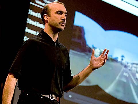
About a year and a half ago, Stephen Lawler, who also gave a talk here at TED in 2007 on Virtual Earth, brought me over to become the architect of Bing Maps, which is Microsoft's online-mapping effort. In the past two and a half, we've been very hard at work on redefining the way maps work online. And we really are seeing this in very different terms from the kind of mapping and direction site that one is used to.
Ongeveer anderhalf jaar geleden was Stephen Lawler hier ook voor een lezing tijdens TED in 2007 over Virtual Earth en hij benoemde me tot architect van Bing Maps, dat is Microsoft's online landkaartenprogramma. Tijdens de laatste 2,5 jaar hebben we erg hard gewerkt om de werking van online kaarten te herdefiniëren. En we gaan er echt anders mee om dan het soort kaarten- en routeplanners-site waar we aan gewend zijn.
So, the first thing that you might notice about the mapping site is just the fluidity of the zooming and the panning, which, if you're familiar at all with Seadragon, that's where it comes from.
Het eerste dat u zal opvallen aan de kaartensite is hoe vloeiend zooming en panning werkt, en als u bekend bent met Seadragon: daar komt het vandaan.
Mapping is, of course, not just about cartography, it's also about imagery. So, as we zoom-in beyond a certain level this resolves into a kind of Sim City-like virtual view at 45 degrees. This can be viewed from any of the cardinal directions to show you the 3D structure of the city, all the facades. Now, we see this space, this three-dimensional environment, as being a canvas on which all sorts of applications can play out, and map's directions are really just one of them.
'Mapping' is natuurlijk niet alleen maar kartografie, het gaat ook over afbeeldingen. Als we dus verder dan een bepaald niveau inzoomen dan gaat het over in een soort Sim City-achtig virtueel panorama onder een hoek van 45 graden. Dit kun je bekijken vanuit elk van de hoofdrichtingen zodat je de 3D-structuur van de stad ziet, alle gevels. Welnu, we zien deze ruimte, deze driedimensionele omgeving als een canvas waarop allerlei applicaties zich kunnen uitleven. En routebeschrijvingen is daar slechts eentje van.
If you click on this, you'll see some of the ones that we've put out, just in the past couple of months since we've launched. So, for example, a couple of days after the disaster in Haiti, we had an earthquake map that showed before and after pictures from the sky. This wonderful one which I don't have time to show you is taking hyper-local blogs in real time and mapping those stories, those entries to the places that are referred to on the blogs. It's wonderful.
Als je hierop klikt dan zie je enkele ervan die we pas de laatste paar maanden erop hebben gezet, sinds we zijn gestart. Bijvoorbeeld, een paar dagen na de ramp op Haïti hadden we een aardbevingskaart die de situatie ervoor en erna toonde vanuit de lucht. Deze prachtige kaart, die ik niet kan laten zien vanwege de tijd, pakt hyper-lokale blogs in real-time op en 'mapt' die verhalen, die teksten op de plaatsen waar de blogs over gaan. Dat is geweldig.
But I'm going to show you some more candy sort of stuff.
Maar ik zal jullie meer krenten uit de pap laten zien.
So, we see the imagery, of course, not stopping at the sky. These little green bubbles represent photosynths that users have made. I'm not going to dive into them either, but photosynths are integrated into the map. Everything that's cased in blue is an area where we've taken imagery on the ground as well.
We zien dat de beelden natuurlijk niet ophouden bij de lucht. Deze groene belletjes vertegenwoordigen photosynths die door gebruikers zijn gemaakt. Daar ga ik ook niet verder op in, maar photosynths zijn geïntegreerd in de kaart. Alles wat blauw omrand is is een gebied waar we ook beelden op de grond hebben gemaakt.
And so, when you fly down --
En dus, als je naar beneden vliegt --
(Applause)
.
Thank you. When you fly down to the ground, and you see this kind of panoramic imagery, the first thing that you might notice is that it's not just a picture, there's just as much three-dimensional understanding of this environment as there is of the three-dimensional city from above, so if I click on something to get a closer view of it, then, the fact that that transition looks as it does, is a function of all of that geometry, all of that 3D understanding behind this model.
Dank u. Als je naar de grond vliegt, en je dit soort panoramabeelden ziet, dan valt het misschien snel op dat het niet alleen maar een foto is, er zit net zoveel driedimensioneel begrip van deze omgeving in als van de driedimensionele stad van bovenaf, dus als ik ergens op klik om het van dichtbij te zien, dan ziet die overgang er zo uit omdat dat een functie van al die geometrie is, al die 3D intelligentie die achter dit model zit.
Now, I'll show you a fun app that -- we've been working on a collaboration with our friends at Flickr. This takes Flickr, georegistered imagery and uses photosynth-like processes to connect that imagery to our imagery, so -- I'm not sure if that's the one I actually meant to pull up, but --
Nu zal ik een leuke app laten zien waar we samen met onze vrienden van Flickr aan hebben gewerkt. Dit neemt geo-geregistreerde foto's van Flickr en gebruikt photosynth-achtige processen om die beelden te verbinden met onze beelden, dus -- Ik weet niet zeker of ik deze wel wilde laten zien, maar --
(Laughter)
.
But notice -- this is, of course, a popular tourist site, and there are lots of photos around here, and these photos are all taken at different times. So this one was taken around five. So that's the Flickr photo, that's our imagery. So you really see how this kind of crowd-sourced imagery is integrating, in a very deep way, into the map itself.
Maar let op -- dit is een populaire plek voor toeristen, en er zijn hier in de omgeving veel foto's, en die foto's zijn allemaal op verschillende momenten genomen. Deze is rond vijf uur genomen. Dat is dan de Flickr foto, dat zijn onze beelden. Je ziet dus hoe deze beelden die door de massa geproduceerd zijn op een diepzinnige manier met de kaart zelf integreren.
(Applause)
.
Thank you.
Dank u.
(Applause)
.
There are several reasons why this is interesting and one of them, of course, is time travel. And I'm not going to show you some of the wonderful historic imagery in here, but there are some with horses and carriages and so on as well. But what's cool about this is that, not only is it augmenting this visual representation of the world with things that are coming in from users, but it also is the foundation for augmented reality, and that's something that I'll be showing you more of in just a moment.
Dit is om een aantal redenen interessant, en een daarvan is natuurlijk tijdreizen. Ik laat jullie niet de prachtige historische beelden zien die hierin zitten, maar er zijn er een aantal met paarden en wagens en zo bij. Wat hier cool aan is, is dat het niet alleen de visuele weergave van de wereld verhoogt met dingen die van gebruikers afkomstig zijn, maar het vormt ook de basis voor de verhoogde werkelijkheid, en dat zal ik zometeen laten zien.
Now I just made a transition indoors. That's also interesting. OK, notice there's now a roof above us. We're inside the Pike Place Market. And this is something that we're able to do with a backpack camera, so, we're now not only imaging in the street with this camera on tops of cars, but we're also imaging inside. And from here, we're able to do the same sorts of registration, not only of still images, but also of video.
Nu ben ik binnenshuis gegaan. Dat is ook boeiend. Let op, er is nu een dak boven ons. We zijn in de Pike Place Market. En dit is iets wat we kunnen doen met een rugzakcamera, we laten dus niet alleen de straat zien met zo'n camera bovenop auto's, maar we maken ook beelden binnenshuis. Van daaruit kunnen we dezelfde soorten van vastlegging doen, niet alleen van foto's maar ook van video.
So this is something that we're now going to try for the first time, live, and this is really, truly, very frightening.
Dus we gaan dit nu proberen, voor het eerst, live, en dit is daadwerkelijk erg beangstigend.
(Laughter)
.
OK.
Oké.
(Ringing)
.
All right, guys, are you there?
Goed, jongens, zijn jullie daar?
(Noise)
.
All right. I'm hitting it. I'm punching play. I'm live. All right. There we go. So, these are our friends in Pike Place Market, the lab.
Goed. Ik druk 'm in. Ik druk op 'play'. Ik ben live. Goed. Daar gaan we. Dit zijn onze vrienden in Pike Place Market, het lab.
(Applause)
.
So they're broadcasting this live. OK, George, can you pan back over to the corner market? Because I want to show points of interest. No, no. The other way. Yeah, yeah, back to the corner, back to the corner. I don't want to see you guys yet. OK, OK, back to the corner, back to the corner, back to the corner. OK, never mind.
Ze zenden dit live uit. Oké, George, kun je met je camera naar het stalletje in de hoek gaan? Want ik wil wat aandachtspunten laten zien. Nee, nee. De andere kant op. Ja, ja. Terug naar de hoek. Terug naar de hoek. Ik wil jullie nu nog niet zien. Oké. Oké. Terug naar de hoek. Terug naar de hoek. Goed, maakt niet uit.
What I wanted to show you was these points of interest over here on top of the image because what that gives you a sense of is the way, if you're actually on the spot, you can think about this -- this is taking a step in addition to augmented reality.
Ik wilde jullie deze aandachtspunten laten zien hier bovenaan het beeld want dan krijg je een besef van wat de weg is, als je daar daadwerkelijk bent ... denk hierover na -- dit is een stap extra naast verhoogde werkelijkheid.
What the hell are you guys -- oh, sorry.
Wat zitten jullie nou -- o sorry.
(Laughter)
.
We're doing two different -- OK, I'm hanging up now. We're doing two different things here. One of them is to take that real ...
We doen twee verschillende ... Goed, ik hang nu op. We doen twee verschillende dingen. Eén ervan is dat je die echte ...
(Laughter)
.
All right, let me just take a moment and thank the team. They've done a fantastic job of pulling this together.
Goed, laten we even het team bedanken. Ze hebben fantastisch werk gedaan om dit voor elkaar te krijgen.
(Applause)
.
I'm going to abandon them now and walk back outside. And while I walk outside, I'll just mention that here we're using this for telepresence, but you can equally well use this on the spot, for augmented reality. When you use it on the spot, it means that you're able to bring all of that metadata and information about the world to you. So here, we're taking the extra step of also broadcasting it. That was being broadcast, by the way, on a 4G network from the market.
Ik verlaat ze nu en loop naar buiten. Terwijl ik buiten loop kan ik even melden dat hier, dit gebruiken we voor telepresence, maar je kunt dit net zo goed gebruiken ter plekke, voor verhoogde werkelijkheid. Als je dit ter plekke gebruikt dan betekent dat dat je al die metadata en informatie over de wereld om je heen kunt meenemen. Hier zetten we dus die extra stap door het ook uit te zenden. Dat werd trouwens uitgezonden via een 4G netwerk vanaf de markt.
All right, and now there's one last TED talk that Microsoft has given in the past several years. And that's Curtis Wong, WorldWide Telescope. So, we're going to head over to the dumpsters, where it's traditional, after a long day at the market, to go out for a break, but also stare up at the sky. This is the integration of WorldWide Telescope into our maps.
Goed, er was een laatste TED lezing door Microsoft in de afgelopen paar jaar. En dat is Curtis Wong, WorldWide Telescope. We gaan daarom naar de afvalcontainers, waar het traditie is om na een lange dag op de markt uit te rusten, maar ook om naar de lucht te staren. Dit is de integratie van WorldWide Telescope met onze kaarten.
(Applause)
.
This is the current -- thank you -- this is the current time. If we scrub the time, then we can see how the sky will look at different times, and we can get all of this very detailed information about different times, different dates: Let's move the moon a little higher in the sky, maybe change the date. I would like to kind of zoom in on the moon. So, this is an astronomically complete representation of the sky integrated right into the Earth.
Dit is de huidige -- dank u -- Dit is de huidige tijd, maar als we de tijd veranderen, dan kunnen we zien hoe de hemel er op verschillende tijden uit ziet, en we kunnen allemaal zeer gedetailleerde informatie krijgen van verschillende tijdstippen en data. Laten we de maan eens wat hoger aan de hemel zetten, misschien de datum veranderen. Ik wil zeg maar inzoomen op de maan. Dit is dus een astronomisch complete representatie van de hemel rechtstreeks geïntegreerd met de aarde.
All right now, I've overrun my time, so I've got to stop. Thank you all very much.
Goed dan, mijn tijd is op, dus ik moet stoppen. Allemaal erg bedankt.
(Applause)
.