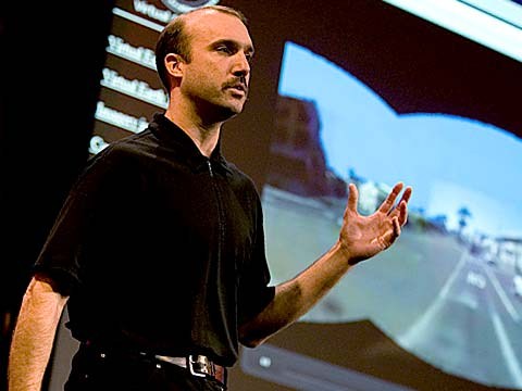
Vor etwa eineinhalb Jahren machte mich Stephen Lawler, der 2007 einen TED-Vortrag über Virtual Earth hielt, zum Entwickler bei Bing Maps, der Kartentechnologie von Microsoft. In den vergangenen zweieinhalb Jahren haben wir hart daran gearbeitet, die Art und Weise, wie Karten online funktionieren, neu zu definieren. Wir verstehen darunter nämlich eine ganz andere Kategorie als die typischen Karten mit Wegbeschreibungen, die wir sonst so gewohnt sind.
About a year and a half ago, Stephen Lawler, who also gave a talk here at TED in 2007 on Virtual Earth, brought me over to become the architect of Bing Maps, which is Microsoft's online-mapping effort. In the past two and a half, we've been very hard at work on redefining the way maps work online. And we really are seeing this in very different terms from the kind of mapping and direction site that one is used to.
Das erste, was Ihnen hier vielleicht auffällt, ist, wie flüssig man hiermit zoomen und schwenken kann. Das kommt von Seadragon, falls Sie das kennen.
So, the first thing that you might notice about the mapping site is just the fluidity of the zooming and the panning, which, if you're familiar at all with Seadragon, that's where it comes from.
Mapping, also das Abbilden auf einer Karte, ist natürlich nicht mehr nur Kartographie, sondern hat auch mit bildlicher Darstellung zu tun. Wenn wir beim Zoomen über ein bestimmtes Level hinaus gehen, führt das zu einer Art Sim-City-ähnlicher virtueller Darstellung im 45-Grad-Winkel. Man kann sich das Bild aus jeder Himmelsrichtung anschauen, und die Stadt mit allen Fassaden in 3D-Struktur sehen. Wir sehen diesen dreidimenionalen Raum als Leinwand, auf die wir alle möglichen Anwendungen übertragen können. Wegbeschreibung ist wirklich nur eine von vielen.
Mapping is, of course, not just about cartography, it's also about imagery. So, as we zoom-in beyond a certain level this resolves into a kind of Sim City-like virtual view at 45 degrees. This can be viewed from any of the cardinal directions to show you the 3D structure of the city, all the facades. Now, we see this space, this three-dimensional environment, as being a canvas on which all sorts of applications can play out, and map's directions are really just one of them.
Wenn ich hierauf klicke, sehen Sie einige jener Anwendungen, die wir in den letzten paar Monaten, seit wir an den Start gegangen sind, herausgebracht haben. Zum Beispiel hatten wir bereits ein paar Tage nach der Katastrophe in Haiti eine Erdbebenkarte, die Vorher-nachher-Bilder aus der Luft zeigte. Diese wunderbare Anwendung, die ich Ihnen hier aus Zeitgründen leider nicht zeigen kann, greift in Echtzeit auf Hyperlocal-Blogs zu und bildet deren Geschichten und Einträge auf die Orte in der Karte ab, die in den Blogs vorkommen. Einfach wunderbar.
If you click on this, you'll see some of the ones that we've put out, just in the past couple of months since we've launched. So, for example, a couple of days after the disaster in Haiti, we had an earthquake map that showed before and after pictures from the sky. This wonderful one which I don't have time to show you is taking hyper-local blogs in real time and mapping those stories, those entries to the places that are referred to on the blogs. It's wonderful.
Stattdessen zeige ich Ihnen jetzt noch ein paar echte Leckerbissen.
But I'm going to show you some more candy sort of stuff.
Wie wir sehen, hört die Grafik natürlich nicht am Himmel auf. Diese kleinen grünen Punkte sind Photosynth-Bilder von Anwendern. Auch die zeige ich jetzt nicht näher, aber solche Fotos sind in die Karte integriert. Alles was hier blau eingerahmt ist, ist ein Gebiet, für das wir auch Bilder vom Boden haben.
So, we see the imagery, of course, not stopping at the sky. These little green bubbles represent photosynths that users have made. I'm not going to dive into them either, but photosynths are integrated into the map. Everything that's cased in blue is an area where we've taken imagery on the ground as well.
Wenn man also da hinunterfliegt -
And so, when you fly down --
(Applaus)
(Applause)
Danke. Wenn man zum Boden hinunterfliegt, sieht man dieses Panoramabild, und als erstes fällt wahrscheinlich auf, dass das nicht nur ein Bild ist, sondern dass diese Umgebung genauso dreidimensional erfasst wird wie die dreidimensionale Stadt von oben. Wenn ich also auf etwas klicke, um es näher zu sehen, sieht dieser Übergang so aus. Das ist eine Funktion dieser Geometrie, der 3D-Erfassung hinter dem Modell.
Thank you. When you fly down to the ground, and you see this kind of panoramic imagery, the first thing that you might notice is that it's not just a picture, there's just as much three-dimensional understanding of this environment as there is of the three-dimensional city from above, so if I click on something to get a closer view of it, then, the fact that that transition looks as it does, is a function of all of that geometry, all of that 3D understanding behind this model.
Ich zeige Ihnen jetzt eine witzige Anwendung, an der wir zusammen mit unseren Freunden von Flickr arbeiten. Sie nimmt ein lokalisiertes Bild von Flickr und verbindet es, in einer Verarbeitung, die der bei Photosynth ähnelt, mit unserer Grafik, - ich weiß nicht, ob ich ausgerechnet dieses Bild haben wollte, aber -
Now, I'll show you a fun app that -- we've been working on a collaboration with our friends at Flickr. This takes Flickr, georegistered imagery and uses photosynth-like processes to connect that imagery to our imagery, so -- I'm not sure if that's the one I actually meant to pull up, but --
(Gelächter)
(Laughter)
Sehen Sie, das hier ist ein beliebter Ort für Touristen, von dem es viele Fotos gibt, die alle zu verschiedenen Zeiten gemacht wurden: Dies hier etwa um fünf Uhr. Das ist das Flickr-Foto, und das ist unsere Grafik. Sie sehen, wie sich diese Bilder aus der Welt der Benutzer fest in die Karte integrieren.
But notice -- this is, of course, a popular tourist site, and there are lots of photos around here, and these photos are all taken at different times. So this one was taken around five. So that's the Flickr photo, that's our imagery. So you really see how this kind of crowd-sourced imagery is integrating, in a very deep way, into the map itself.
(Applaus)
(Applause)
Vielen Dank.
Thank you.
(Applaus)
(Applause)
Das ist aus verschiedenen Gründen interessant, zum Beispiel für Zeitreisen. Ich kann Ihnen jetzt nichts von den wunschönen historischen Bildern zeigen, es gibt nämlich auch ein paar mit Pferden und Kutschen und so weiter. Das Coole daran ist, dass es nicht nur darum geht, die visuelle Darstellung der Welt mit dem zu erweitern, was die Anwender dazu beisteuern, sondern dass so auch die Grundlage für Augmented-Reality gelegt wird, von der ich Ihnen gleich mehr zeigen werde.
There are several reasons why this is interesting and one of them, of course, is time travel. And I'm not going to show you some of the wonderful historic imagery in here, but there are some with horses and carriages and so on as well. But what's cool about this is that, not only is it augmenting this visual representation of the world with things that are coming in from users, but it also is the foundation for augmented reality, and that's something that I'll be showing you more of in just a moment.
Ich bin jetzt nach drinnen gegangen. Auch das ist interessant. Sie sehen, dass jetzt ein Dach über uns ist. Wir sind im Pike Place Markt. Das machen wir mit einer Rucksackkamera. Wir fotografieren also nicht nur auf der Straße mit diesen Kameras auf Autodächern, sondern wir machen auch Bilder von Innenräumen. Und wir können hier dieselben Verknüpfungen herstellen, nicht nur von Standbildern, sondern auch von Videos.
Now I just made a transition indoors. That's also interesting. OK, notice there's now a roof above us. We're inside the Pike Place Market. And this is something that we're able to do with a backpack camera, so, we're now not only imaging in the street with this camera on tops of cars, but we're also imaging inside. And from here, we're able to do the same sorts of registration, not only of still images, but also of video.
Das probieren wir jetzt mal aus, zum ersten Mal live, und davor habe ich jetzt wirklich einen ganz schönen Bammel.
So this is something that we're now going to try for the first time, live, and this is really, truly, very frightening.
(Gelächter)
(Laughter)
Okay.
OK.
(Telefon läutet)
(Ringing)
Okay, Jungs, seid ihr da?
All right, guys, are you there?
(Lärm)
(Noise)
Okay. Ich gehe drauf. Ich drücke auf Wiedergabe. Ich bin live. Okay. Los geht's. Das hier sind unsere Freunde im Pike Place Markt, dem Labor.
All right. I'm hitting it. I'm punching play. I'm live. All right. There we go. So, these are our friends in Pike Place Market, the lab.
(Applaus)
(Applause)
Sie senden das jetzt live. Okay, George, kannst du zurück zum Markt in der Ecke schwenken? Weil ich ein paar Sehenswürdigkeiten zeigen will. Nein, nein. Andersrum. Ja, ja, zurück in die Ecke. Zurück in die Ecke. Euch will ich jetzt noch nicht sehen. Okay. Okay. Zurück in die Ecke. Zurück in die Ecke. Zurück in die Ecke. Okay, egal.
So they're broadcasting this live. OK, George, can you pan back over to the corner market? Because I want to show points of interest. No, no. The other way. Yeah, yeah, back to the corner, back to the corner. I don't want to see you guys yet. OK, OK, back to the corner, back to the corner, back to the corner. OK, never mind.
Ich wollte Ihnen eigentlich diese Sehenswürdigkeiten hier oben im Bild zeigen, denn da bekommt man das Gefühl, als wäre man tatsächlich da... Das könnte man als einen Schritt ansehen, der noch einen Schritt weiter geht als Augmented-Reality.
What I wanted to show you was these points of interest over here on top of the image because what that gives you a sense of is the way, if you're actually on the spot, you can think about this -- this is taking a step in addition to augmented reality.
Was zum Teufel macht ihr da - oh, Entschuldigung.
What the hell are you guys -- oh, sorry.
(Gelächter)
(Laughter)
Wir machen zwei verschiedene... Okay, ich lege jetzt auf. Wir machen hier zwei verschiedene Dinge. Erstens nehmen wir reale...
We're doing two different -- OK, I'm hanging up now. We're doing two different things here. One of them is to take that real ...
(Gelächter)
(Laughter)
Okay, lassen Sie mich die Gelegenheit nutzen und dem Team danken. Sie haben das ganz fantastisch hingekriegt.
All right, let me just take a moment and thank the team. They've done a fantastic job of pulling this together.
(Applaus)
(Applause)
Ich verlasse sie jetzt und gehe wieder nach draußen. Und während ich hinausgehe, sage ich noch kurz, dass wir das hier jetzt zwar für die Telepräsenz nutzen, aber man das genausogut vor Ort nutzen, für Augmented-Reality. Wenn man es vor Ort nutzt, heißt das, dass man all diese vielen Metadaten und Informationen über die Welt zu sich holen kann. Wir machen also hier einen nächsten Schritt, indem wir es live übertragen. Das wurde übrigens auf einem 4G-Netzwerk von dem Markt aus gesendet.
I'm going to abandon them now and walk back outside. And while I walk outside, I'll just mention that here we're using this for telepresence, but you can equally well use this on the spot, for augmented reality. When you use it on the spot, it means that you're able to bring all of that metadata and information about the world to you. So here, we're taking the extra step of also broadcasting it. That was being broadcast, by the way, on a 4G network from the market.
Jetzt gibt es einen TED-Vortrag, den letzten, den Microsoft in den letzten Jahren gehalten hat. Das war Curtis Wong, WorldWide Telescope. Wir gehen jetzt rüber zu den Müllcontainern, wo man üblicherweise nach einem langen Tag auf dem Markt eine Pause macht, oder einfach nur in den Himmel schaut. Hier ist das WorldWide Telescope in unsere Karten integriert.
All right, and now there's one last TED talk that Microsoft has given in the past several years. And that's Curtis Wong, WorldWide Telescope. So, we're going to head over to the dumpsters, where it's traditional, after a long day at the market, to go out for a break, but also stare up at the sky. This is the integration of WorldWide Telescope into our maps.
(Applaus)
(Applause)
Das ist die aktuelle ... vielen Dank. Das ist die aktuelle Zeit, aber wenn wir die löschen, können wir sehen, wie der Himmel zu verschiedenen Uhrzeiten aussehen wird, und bekommen sehr detaillierte Informationen über verschiedene Zeitpunkte. Schieben wir mal den Mond etwas höher, und verändern vielleicht das Datum. Ich würde gerne an den Mond heranzoomen. Das hier ist eine astronomisch vollständige Abbildung des Himmels, die direkt in das Bild der Erde integriert wurde.
This is the current -- thank you -- this is the current time. If we scrub the time, then we can see how the sky will look at different times, and we can get all of this very detailed information about different times, different dates: Let's move the moon a little higher in the sky, maybe change the date. I would like to kind of zoom in on the moon. So, this is an astronomically complete representation of the sky integrated right into the Earth.
Okay, meine Zeit ist abgelaufen, ich muss Schluss machen. Ich danke Ihnen allen vielmals.
All right now, I've overrun my time, so I've got to stop. Thank you all very much.
(Applaus)
(Applause)