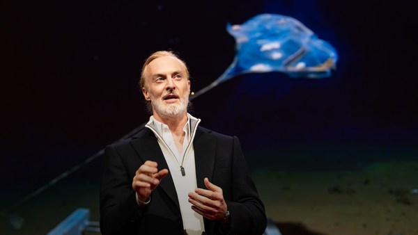
We know more about other planets than our own, and today, I want to show you a new type of robot designed to help us better understand our own planet. It belongs to a category known in the oceanographic community as an unmanned surface vehicle, or USV. And it uses no fuel. Instead, it relies on wind power for propulsion. And yet, it can sail around the globe for months at a time. So I want to share with you why we built it, and what it means for you.
Diğer gezegenler hakkında kendi gezegenimizden daha fazla şey biliyoruz ve bugün sizlere kendi gezegenimizi daha iyi anlamak için tasarlanmış yeni bir tür robot göstermek istiyorum. Okyanus bilimi camiasında insansız yüzey aracı veya İYA diye bilinen bir kategoriye ait. Ve herhangi bir yakıt kullanmıyor. Onun yerine, ilerlemek için rüzgâr gücüne ihtiyaç duyuyor. Ancak Dünya etrafında yelkenle aylarca gidebiliyor. Sizlerle onu neden yaptığımızı ve sizin için ne anlama geldiğini paylaşmak istiyorum.
A few years ago, I was on a sailboat making its way across the Pacific, from San Francisco to Hawaii. I had just spent the past 10 years working nonstop, developing video games for hundreds of millions of users, and I wanted to take a step back and look at the big picture and get some much-needed thinking time. I was the navigator on board, and one evening, after a long session analyzing weather data and plotting our course, I came up on deck and saw this beautiful sunset. And a thought occurred to me: How much do we really know about our oceans? The Pacific was stretching all around me as far as the eye could see, and the waves were rocking our boat forcefully, a sort of constant reminder of its untold power. How much do we really know about our oceans? I decided to find out.
Birkaç yıl önce, Pasifik'te San Francisco'dan Hawaii'ye yol alan bir yelkenli içindeydim. Son 10 yılı hiç durmadan yüz binlerce kullanıcısı olan video oyunları geliştirmek için harcamıştım ve bir adım geriye gidip büyük resme bakmak ve zamanımı ihtiyacını duyduğum düşünme ile geçirmek istedim. Teknede rotacıydım ve bir akşam, hava durumunu analiz edip yolumuzu çizdiğim uzun bir seanstan sonra güverteye gelip bu güzel güneş batışını gördüm. Aklıma bir fikir geldi: Okyanuslarımız hakkında aslında ne kadar şey biliyoruz? Pasifik etrafımda gözlerin görebileceği kadar uzaklara gidiyordu ve dile getirilmeyen gücünü hatırlatır şekilde dalgalar tekneyi tüm gücüyle sallıyordu. Okyanuslar hakkında aslında ne kadar şey biliyoruz? Öğrenmeye karar verdim.
What I quickly learned is that we don't know very much. The first reason is just how vast oceans are, covering 70 percent of the planet, and yet we know they drive complex planetary systems like global weather, which affect all of us on a daily basis, sometimes dramatically. And yet, those activities are mostly invisible to us.
Çabucak öğrendiğim ki pek fazla bir şey bilmiyoruz. Bunun ilk nedeni, okyanusların çok geniş bir alanı, gezegenimizin yüzde 70'ini kaplıyor olması, ve küresel hava durumu gibi karmaşık sistemlerini işletiyor olmaları ki bunlar günlük hayatlarımızı etkiliyor, bazen çok yoğun bir şekilde. Ancak bunların çoğu bizlerin görebildiği olaylar değil.
Ocean data is scarce by any standard. Back on land, I had grown used to accessing lots of sensors -- billions of them, actually. But at sea, in situ data is scarce and expensive. Why? Because it relies on a small number of ships and buoys. How small a number was actually a great surprise. Our National Oceanic and Atmospheric Administration, better known as NOAA, only has 16 ships, and there are less than 200 buoys offshore globally. It is easy to understand why: the oceans are an unforgiving place, and to collect in situ data, you need a big ship, capable of carrying a vast amount of fuel and large crews, costing hundreds of millions of dollars each, or, big buoys tethered to the ocean floor with a four-mile-long cable and weighted down by a set of train wheels, which is both dangerous to deploy and expensive to maintain.
Her şekilde okyanus verisi az. Karada, birçok sensöre erişimim olmasına alıştım -- milyarlarca aslında. Ancak denizde anlık veri az ve pahalı. Neden? Çünkü az sayıda gemi ve şamandıraya dayanıyor. Bu sayının çok küçük olması aslında büyük sürpriz. NOAA olarak bilinen Ulusal Okyanus ve Atmosfer Dairesi'nin sadece 16 gemisi var ve küresel olarak denizde 200 şamandıradan az var. Nedenini anlamak kolay: Okyanuslar affetmeyen yerler ve anlık veriyi toplamak için her biri milyonlarca dolar olan, büyük miktarlarda yakıt ve büyük bir ekip taşıyabilen büyük bir gemiye veya 6,43 km uzunluğunda kablo ile okyanus tabanına bağlanan ve bir dizi tren tekerleği ile batırılan büyük şamandıralara ihtiyaç var ki hem yerleştirmesi zor, hem de koruması pahalı.
What about satellites, you might ask? Well, satellites are fantastic, and they have taught us so much about the big picture over the past few decades. However, the problem with satellites is they can only see through one micron of the surface of the ocean. They have relatively poor spatial and temporal resolution, and their signal needs to be corrected for cloud cover and land effects and other factors.
Peki ya uydular diye sorabilirsiniz. Uydular harika ve birkaç on yıldır bize büyük resim hakkında çok fazla şey öğrettiler. Ancak uydularla ilgili sorun okyanus yüzeyinin sadece bir mikronunu görebilirler. Nispeten zayıf uzaysal ve dünyasal çözünürlüğe sahip ve sinyaller bulut kaplaması, kara efekti ve diğer faktörler için düzeltilmeli.
So what is going on in the oceans? And what are we trying to measure? And how could a robot be of any use?
Peki okyanuslarda neler oluyor? Ne ölçmeye çalışıyoruz? Bir robot nasıl yardımcı olabilir?
Let's zoom in on a small cube in the ocean. One of the key things we want to understand is the surface, because the surface, if you think about it, is the nexus of all air-sea interaction. It is the interface through which all energy and gases must flow. Our sun radiates energy, which is absorbed by oceans as heat and then partially released into the atmosphere. Gases in our atmosphere like CO2 get dissolved into our oceans. Actually, about 30 percent of all global CO2 gets absorbed. Plankton and microorganisms release oxygen into the atmosphere, so much so that every other breath you take comes from the ocean.
Okyanusta küçük br kübe odaklanalım. Anlamak istediğiniz önemli şeylerden biri yüzey, çünkü yüzey, eğer düşünürseniz, tüm hava-deniz etkileşiminin bağlantı noktası. Tüm enerji ve gazların aktığı arayüzdür. Güneşimiz enerji yayar ki bu okyanuslar tarafından ısı olarak emilir ve sonra kısmen atmosfere bırakılır. Atmosferimizde karbondioksit gibi gazlar okyanuslarda çözünür. Aslında, küresel karbondioksitin yüzde 30'u emiliyor. Plankton ve mikroorganizmalar atmosfere oksijen bırakıyorlar, öylesine ki aldığınız iki nefesten biri okyanustan geliyor.
Some of that heat generates evaporation, which creates clouds and then eventually leads to precipitation. And pressure gradients create surface wind, which moves the moisture through the atmosphere. Some of the heat radiates down into the deep ocean and gets stored in different layers, the ocean acting as some kind of planetary-scale boiler to store all that energy, which later might be released in short-term events like hurricanes or long-term phenomena like El Niño. These layers can get mixed up by vertical upwelling currents or horizontal currents, which are key in transporting heat from the tropics to the poles. And of course, there is marine life, occupying the largest ecosystem in volume on the planet, from microorganisms to fish to marine mammals, like seals, dolphins and whales.
Isının bir kısmı buharlaşma yaratıyor, bu da bulut yaratıyor ve sonunda yağışa dönüşüyor. Basınç değişimleri yüzey rüzgârı yaratır, bu da nemin atmosferde hareket etmesini sağlar. Isının bir kısmı derin okyanusa doğru yayılır ve farklı tabakalarda depolanır, okyanus bütün o enerjiyi depolamak için gezegen büyüklüğünde bir kazan gibi davranır, enerji sonradan kasırgalar gibi kısa dönemli olaylarla veya El Niño gibi uzun dönemli olgularla bırakılır. Bu katmanlar dikey akan akıntılarla veya yatay akıntılarla karışabilir ki bunlar tropik bölgelerden kutuplara ısı taşınmasında önemlidir. Elbette deniz hayatı bulunmaktadır, mikroorganizmalardan balıklara ve fok, yunus ve balinalar gibi deniz memelilerine kadar gezegende hacim olarak en büyük ekosistemi kaplar.
But all of these are mostly invisible to us. The challenge in studying those ocean variables at scale is one of energy, the energy that it takes to deploy sensors into the deep ocean. And of course, many solutions have been tried -- from wave-actuated devices to surface drifters to sun-powered electrical drives -- each with their own compromises. Our team breakthrough came from an unlikely source -- the pursuit of the world speed record in a wind-powered land yacht. It took 10 years of research and development to come up with a novel wing concept that only uses three watts of power to control and yet can propel a vehicle all around the globe with seemingly unlimited autonomy. By adapting this wing concept into a marine vehicle, we had the genesis of an ocean drone.
Ancak bunların büyük bölümü çoğunlukla bize görünmezdir. Bu okyanus değişkenlerini ölçekte araştırmanın sorunu enerjidir, sensörleri derin okyanusa göndermek için gerekli olan enerji. Elbette pek çok çözüm denendi -- dalgayla harekete geçen cihazlardan yüzey teknelerine, güneşle çalışan elektrikli taşıtlara -- her birinin kendine özgü ödünü vardı. Ekibimizin buluşu tahmin edilmeyen bir kaynaktan geldi -- rüzgârla çalışan kara yatında dünya hız rekor denemesi. Yeni bir kanat konseptini bulmak için 10 yıl araştırma ve geliştirme yapmak gerekti, ki bu konsept kontrol etmek için sadece üç vat güç kullanıyor ve göründüğü kadarıyla sınırsız otonomi ile bir taşıtı dünya etrafında döndürebiliyor. Bu kanat konseptini deniz aracına uygulayarak okyanus dronunun doğuşunu sağladık.
Now, these are larger than they appear. They are about 15 feet high, 23 feet long, seven feet deep. Think of them as surface satellites. They're laden with an array of science-grade sensors that measure all key variables, both oceanographic and atmospheric, and a live satellite link transmits this high-resolution data back to shore in real time. Our team has been hard at work over the past few years, conducting missions in some of the toughest ocean conditions on the planet, from the Arctic to the tropical Pacific. We have sailed all the way to the polar ice shelf. We have sailed into Atlantic hurricanes. We have rounded Cape Horn, and we have slalomed between the oil rigs of the Gulf of Mexico. This is one tough robot.
Bunlar göründüğünden daha büyük. 4,5 metre yükseklikte, yedi metre uzunlukta, iki metre derinlikteler. Onlara yüzey uyduları olarak bakabilirsiniz. Hem oşinografik, hem de atmosferik tüm kilit değişkenleri ölçen bilim sınıfı sensörlerle yüklü ve canlı yayın uydusu bu yüksek çözünürlüklü veriyi gerçek zamanlı olarak kıyıya aktarıyor. Ekibimiz son birkaç yıldır çok yoğundu, Kuzey Kutbu'ndan Pasifik'e kadar gezegenin en zor okyanus koşullarının olduğu bazı yerlerde görevler yapıyorlardı. Ta kutup buzuluna kadar yelkenle gittik. Atlantik fırtınalarının içinde gittik. Horn Burnu'nu geçtik ve Meksika Körfezi'ndeki petrol kuleleri arasında slalom yaptık. Çok dayanıklı bir robot.
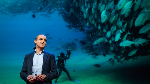
Let me share with you recent work that we did around the Pribilof Islands. This is a small group of islands deep in the cold Bering Sea between the US and Russia. Now, the Bering Sea is the home of the walleye pollock, which is a whitefish you might not recognize, but you might likely have tasted if you enjoy fish sticks or surimi. Yes, surimi looks like crabmeat, but it's actually pollock. And the pollock fishery is the largest fishery in the nation, both in terms of value and volume -- about 3.1 billion pounds of fish caught every year.
Pribilof Adaları'nın etrafında henüz yaptığımız bir görevden bahsedeyim. Bu, ABD ve Rusya arasındaki soğuk Bering Denizi derinlerinde küçük bir ada grubu. Bering Denizi hatırlamayacağınız beyaz bir balık olan Alaska Mezgiti'nin evidir, ancak bu balığı eğer balık çubukları veya surimi yedinizse tatmışsınızdır. Evet, surimi yengeç etine benzer ama aslında mezgittir. Mezgit avcılığı ülkedeki en büyük balık avcılığıdır, hem değer, hem de hacim açısından -- her yıl 1,4 milyar kg balık yakalanır.
So over the past few years, a fleet of ocean drones has been hard at work in the Bering Sea with the goal to help assess the size of the pollock fish stock. This helps improve the quota system that's used to manage the fishery and help prevent a collapse of the fish stock and protects this fragile ecosystem. Now, the drones survey the fishing ground using acoustics, i.e., a sonar. This sends a sound wave downwards, and then the reflection, the echo from the sound wave from the seabed or schools of fish, gives us an idea of what's happening below the surface. Our ocean drones are actually pretty good at this repetitive task, so they have been gridding the Bering Sea day in, day out.
Son birkaç yıldır bir filo okyanus dronu mezgit balığı stoğunun büyüklüğünü ölçmek amacıyla Bering Denizi'nde yoğun çalışıyordu. Bu, balık avlama bölgesinin yönetiminde kullanılan kota sistemini geliştirmeye, balık stoklarında çöküşü önlemeye yardımcı oluyor ve bu kırılgan ekosistemi koruyor. Dronlar akustik yani sonar kullanarak balıkçılık alanlarını araştırıyorlar. Bu, aşağıya doğru bir ses dalgası gönderir ve sonra yansıma, deniz yatağı ya da balık kolonisinden gelen ses dalgası yankısı yüzey altında neler olduğu hakkında bir fikir verir. Okyanus dronlarımız aslında bu tekrarlayan görevi yapmakta oldukça iyiler, bu yüzden Bering Denizi'ni her gün dolaşıyorlardı.
Now, the Pribilof Islands are also the home of a large colony of fur seals. In the 1950s, there were about two million individuals in that colony. Sadly, these days, the population has rapidly declined. There's less than 50 percent of that number left, and the population continues to fall rapidly. So to understand why, our science partner at the National Marine Mammal Laboratory has fitted a GPS tag on some of the mother seals, glued to their furs. And this tag measures location and depth and also has a really cool little camera that's triggered by sudden acceleration. Here is a movie taken by an artistically inclined seal, giving us unprecedented insight into an underwater hunt deep in the Arctic, and the shot of this pollock prey just seconds before it gets devoured.
Aynı zamanda, Pribilof Adaları büyük bir kürklü fok kolonisine evdir. 1950'lerde bu kolonide iki milyon birey vardı. Ne yazık ki günümüzde nüfus hızla düştü. Bu sayının yüzde 50'sinden azı kaldı ve nüfus hızla düşmeye devam ediyor. Nedenini anlamak için bilim ortağımız Ulusal Deniz Memelileri Laboratuvarı bazı anne fokların derilerine GPS etiketi yapıştırdı. Bu etiket yer ve derinliği ölçüyor ve ani hızlanma ile tetiklenen gerçekten küçük, hoş bir kamerası var. Bu film sanata meyilli bir fok tarafından çekildi, Kuzey Kutbu derinliklerindeki su altı avı hakkında benzersiz bir anlayış veriyor ve yutulmadan saniyeler önce bu mezgit avından bir kare.
Now, doing work in the Arctic is very tough, even for a robot. They had to survive a snowstorm in August and interferences from bystanders -- that little spotted seal enjoying a ride.
Kuzey Kutbu'nda görev yapmak çok zor, bir robot için bile. Ağustos'ta kar fırtınasında ve seyircilerin müdahalesinde hayatta kalmalılar -- bu küçük benekli fok sürüş keyfi yaşıyor.
(Laughter)
(Gülüşmeler)
Now, the seal tags have recorded over 200,000 dives over the season, and upon a closer look, we get to see the individual seal tracks and the repetitive dives. We are on our way to decode what is really happening over that foraging ground, and it's quite beautiful. Once you superimpose the acoustic data collected by the drones, a picture starts to emerge. As the seals leave the islands and swim from left to right, they are observed to dive at a relatively shallow depth of about 20 meters, which the drone identifies is populated by small young pollock with low calorific content. The seals then swim much greater distance and start to dive deeper to a place where the drone identifies larger, more adult pollock, which are more nutritious as fish. Unfortunately, the calories expended by the mother seals to swim this extra distance don't leave them with enough energy to lactate their pups back on the island, leading to the population decline. Further, the drones identify that the water temperature around the island has significantly warmed. It might be one of the driving forces that's pushing the pollock north, and to spread in search of colder regions. So the data analysis is ongoing, but already we can see that some of the pieces of the puzzle from the fur seal mystery are coming into focus.
Fok etiketleri mevsim boyunca 200.000 dalış kaydetmiş ve daha yakından bakınca tek tek fok yollarını ve tekrarlayan dalışları görüyoruz. O yiyecek arama alanında gerçekten neler olduğunu anlamak üzere yola çıktık ve oldukça güzel. Dronların topladığı akustik veriyi birleştirmeye başlayınca, bir resim ortaya çıkmaya başlar. Foklar adayı terk edip soldan sağa yüzünce, yaklaşık 20 metre derinliğinde alçak sayılır yere daldıkları gözlemleniyor, dron buranın düşük kalori içeriği olan küçük, genç mezgitlerle dolu olduğunu tanımlıyor. Foklar sonra daha uzaklara yüzüp daha derine dalıyorlar, burada dron balık kadar besleyici olan daha büyük, yetişkin mezgitleri tanımlıyor. Ne yazık ki anne foklar tarafından bu ekstra mesafeye harcanan kaloriler yavrularını adada emzirmek için yeterli enerjiyi bırakmıyor, bu da nüfusun düşmesine sebep oluyor. Dahası, dronlar ada etrafında su sıcaklığının kayda değer derecede arttığını tanımlıyorlar. Bu mezgitleri kuzeye gitmeye ve daha soğuk bölgeleri aramak için yayılmaya zorlayan nedenlerden biri olabilir. Veri analizleri devam ediyor ama hâlihazırda kürklü fok sırrında bulmaca parçalarından bir kısmının göz önüne geldiğini görüyoruz.
But if you look back at the big picture, we are mammals, too. And actually, the oceans provide up to 20 kilos of fish per human per year. As we deplete our fish stocks, what can we humans learn from the fur seal story? And beyond fish, the oceans affect all of us daily as they drive global weather systems, which affect things like global agricultural output or can lead to devastating destruction of lives and property through hurricanes, extreme heat and floods. Our oceans are pretty much unexplored and undersampled, and today, we still know more about other planets than our own.
Eğer büyük resme bakarsanız, biz de memeliyiz. Aslında okyanuslar yılda insan başına 20 kg balık sağlıyor. Balık stoklarımızı tüketirken, kürklü fok hikâyesinden biz insanlar neler öğrenebiliriz? Balıkların ötesinde, okyanuslar küresel hava sistemlerini yönetirken bizi günlük olarak etkiliyor, ki bu sistemler küresel tarım ürünlerini etkiler veya fırtınalar, aşırı sıcak ve seller yüzünden hayatlara ve mala yıkıcı tahribat bırakabilir. Okyanuslarımız oldukça keşfedilmemiş ve az örneklem alınmış durumda, bugün hâlâ diğer gezegenler hakkında kendi gezegenimizden
But if you divide this vast ocean in six-by-six-degree squares,
daha fazla şey biliyoruz.
each about 400 miles long, you'd get about 1,000 such squares. So little by little, working with our partners, we are deploying one ocean drone in each of those boxes, the hope being that achieving planetary coverage will give us better insights into those planetary systems that affect humanity.
Bu büyük okyanusu altıya altı derece karelere bölerseniz, her biri 643 km uzunluğunda olan böyle 1.000 kareniz olur. Böyle az az, ortaklarımızla çalışarak, her bir kutuya bir okyanus dronu yerleştiriyoruz, umudumuz gezegeni kapsama alanına almanın bize insanlığı etkileyen diğer gezegen sistemleri hakkında daha iyi içgörüler vermesi.
We have been using robots to study distant worlds in our solar system for a while now. Now it is time to quantify our own planet, because we cannot fix what we cannot measure, and we cannot prepare for what we don't know.
Güneş sistemimizdeki uzak dünyaları araştırmak için bir süredir robotları kullanıyorduk. Artık dünyamızı ölçmenin zamanı, çünkü ölçemediğimiz şeyleri düzeltemeyiz ve bilmediğimiz şeylere hazırlık yapamayız.
Thank you.
Teşekkürler.
(Applause)
(Alkış)