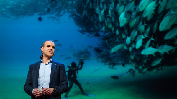
We know more about other planets than our own, and today, I want to show you a new type of robot designed to help us better understand our own planet. It belongs to a category known in the oceanographic community as an unmanned surface vehicle, or USV. And it uses no fuel. Instead, it relies on wind power for propulsion. And yet, it can sail around the globe for months at a time. So I want to share with you why we built it, and what it means for you.
Wiemy więcej o innych planetach niż o naszej własnej, chcę wam dziś pokazać nowy typ robota, stworzonego, aby pomógł nam lepiej zrozumieć naszą planetę. Należy do kategorii znanej w społeczności oceanograficznej jako bezzałogowy pojazd nawodny, USV. Nie zużywa paliwa. Napędzany jest siłą wiatru. Mimo to może pływać po całym świecie miesiącami. Chcę podzielić się z wami powodem jego budowy, i co to dla was oznacza.
A few years ago, I was on a sailboat making its way across the Pacific, from San Francisco to Hawaii. I had just spent the past 10 years working nonstop, developing video games for hundreds of millions of users, and I wanted to take a step back and look at the big picture and get some much-needed thinking time. I was the navigator on board, and one evening, after a long session analyzing weather data and plotting our course, I came up on deck and saw this beautiful sunset. And a thought occurred to me: How much do we really know about our oceans? The Pacific was stretching all around me as far as the eye could see, and the waves were rocking our boat forcefully, a sort of constant reminder of its untold power. How much do we really know about our oceans? I decided to find out.
Kilka lat temu byłem na żaglówce płynącej przez Pacyfik z San Francisco na Hawaje. Poprzednie 10 lat spędziłem na ciągłej pracy, rozwijając gry video dla setek milionów użytkowników. Chciałem spojrzeć na wszystko z szerszej perspektywy, zyskać trochę czasu na myślenie. Byłem nawigatorem na pokładzie. Pewnego wieczora, po długiej sesji analizowania danych pogodowych i wykreślaniu naszego kursu, poszedłem na pokład i zobaczyłem ten piękny zachód słońca. Wówczas przyszła mi do głowy myśl: Ile tak naprawdę wiemy o naszych ocenach? Wokół mnie, jak okiem sięgnąć, rozpościerał się Pacyfik, fale silnie kołysały statkiem, jakby nieustannie przypominały o swojej niewyobrażalnej mocy. Ile tak naprawdę wiemy o naszych oceanach? Postanowiłem się dowiedzieć.
What I quickly learned is that we don't know very much. The first reason is just how vast oceans are, covering 70 percent of the planet, and yet we know they drive complex planetary systems like global weather, which affect all of us on a daily basis, sometimes dramatically. And yet, those activities are mostly invisible to us.
Szybko odkryłem, że nie wiemy zbyt wiele. Pierwszym powodem jest bezmiar oceanów, pokrywają 70% planety. Mimo to wiemy, że napędzają złożone systemy planetarne, jak pogoda w skali globalnej, co ma wpływ na nas wszystkich na co dzień. I czasami ten wpływ jest dramatyczny. Mimo to, te działania są w większości dla nas niewidzialne.
Ocean data is scarce by any standard. Back on land, I had grown used to accessing lots of sensors -- billions of them, actually. But at sea, in situ data is scarce and expensive. Why? Because it relies on a small number of ships and buoys. How small a number was actually a great surprise. Our National Oceanic and Atmospheric Administration, better known as NOAA, only has 16 ships, and there are less than 200 buoys offshore globally. It is easy to understand why: the oceans are an unforgiving place, and to collect in situ data, you need a big ship, capable of carrying a vast amount of fuel and large crews, costing hundreds of millions of dollars each, or, big buoys tethered to the ocean floor with a four-mile-long cable and weighted down by a set of train wheels, which is both dangerous to deploy and expensive to maintain.
Ilość danych oceanicznych jest znikoma według jakiegokolwiek standardów. Na lądzie przyzwyczailiśmy się do dostępu do mnóstwa czujników, w zasadzie milionów. Ale na morzu obserwacja in situ jest rzadka i droga. Dlaczego? Ponieważ zależy od niewielkiej liczby statków i boi. Jak małej? Było to właściwie wielką niespodzianką. Amerykańska Narodowa Służba Oceaniczna i Meteorologiczna, znana lepiej jako NOAA, ma tylko 16 statków, a globalnie na pełnym morzu jest mniej niż 200 boi. Łatwo jest zrozumieć, dlaczego: oceany to bezlitosne miejsce i aby zebrać dane bezpośrednio potrzebny jest duży statek, zdolny do transportu ogromnej ilości paliwa i licznej załogi, każdy o wartości setek milionów dolarów lub boi przymocowanych do dna oceanu 6,5 kilometrowym kablem i obciążonych zestawem kół pociągowych, co jest zarówno niebezpieczne w montażu, jak i kosztowne w utrzymaniu.
What about satellites, you might ask? Well, satellites are fantastic, and they have taught us so much about the big picture over the past few decades. However, the problem with satellites is they can only see through one micron of the surface of the ocean. They have relatively poor spatial and temporal resolution, and their signal needs to be corrected for cloud cover and land effects and other factors.
Co z satelitami, zapytacie? Satelity są fantastyczne, nauczyły nas wiele o całokształcie sytuacji przez ostatnie kilka dziesięcioleci. Jednak problem z satelitami polega na tym, że widzą powierzchnię oceanu tylko do głębokości 1 mikrona. Mają stosunkowo słabą przestrzenną i czasową rozdzielczość i ich sygnał musi być korygowany, z powodu pokrywy chmur i lądu oraz inne czynniki.
So what is going on in the oceans? And what are we trying to measure? And how could a robot be of any use?
Co więc dzieje się w oceanach? Co próbujemy mierzyć? Jak przydatny może być robot?
Let's zoom in on a small cube in the ocean. One of the key things we want to understand is the surface, because the surface, if you think about it, is the nexus of all air-sea interaction. It is the interface through which all energy and gases must flow. Our sun radiates energy, which is absorbed by oceans as heat and then partially released into the atmosphere. Gases in our atmosphere like CO2 get dissolved into our oceans. Actually, about 30 percent of all global CO2 gets absorbed. Plankton and microorganisms release oxygen into the atmosphere, so much so that every other breath you take comes from the ocean.
Powiększmy małą kostkę oceanu. Jedną z rzeczy, którą chcemy zrozumieć jest powierzchnia, ponieważ jest ona miejscem interakcji powietrze-morze. To interfejs, przez który energia i gazy muszą przeniknąć. Słońce emituje energię, która jest absorbowana przez oceany jako ciepło, a następnie częściowo uwalniana do atmosfery. Gazy zawarte w powietrzu, jak CO2, rozpuszczają się w oceanach. Około 30% ogólnej ilości CO2 ulega absorpcji. Plankton i mikroorganizmy uwalniają tlen do atmosfery w takich ilościach, że co drugi nasz oddech pochodzi z oceanu.
Some of that heat generates evaporation, which creates clouds and then eventually leads to precipitation. And pressure gradients create surface wind, which moves the moisture through the atmosphere. Some of the heat radiates down into the deep ocean and gets stored in different layers, the ocean acting as some kind of planetary-scale boiler to store all that energy, which later might be released in short-term events like hurricanes or long-term phenomena like El Niño. These layers can get mixed up by vertical upwelling currents or horizontal currents, which are key in transporting heat from the tropics to the poles. And of course, there is marine life, occupying the largest ecosystem in volume on the planet, from microorganisms to fish to marine mammals, like seals, dolphins and whales.
Część ciepła powoduje parowanie, w wyniku którego tworzą się chmury, z których powstają opady. Zmiany ciśnienia powodują powierzchniowy wiatr, który przenosi wilgoć poprzez atmosferę. Część ciepła przechodzi w głąb oceanu i jest magazynowana w różnych warstwach. Ocean działa jako pewnego rodzaju boiler o skali planetarnej, magazynujący całą energię, która później może być uwolniona w postaci gwałtownych wydarzeń jak huragany lub długoterminowych zjawisk jak El Niño. Warstwy te mogą ulec wymieszaniu wskutek pionowych prądów wstępujących lub prądów poziomych, które są kluczowe w transporcie ciepła z tropików do biegunów. I oczywiście jest tu życie morskie, zajmujące największy objętościowo ekosystem na planecie, od mikroorganizmów, poprzez ryby, do ssaków morskich, jak foki, delfiny i wieloryby.
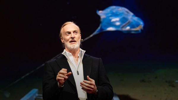
But all of these are mostly invisible to us. The challenge in studying those ocean variables at scale is one of energy, the energy that it takes to deploy sensors into the deep ocean. And of course, many solutions have been tried -- from wave-actuated devices to surface drifters to sun-powered electrical drives -- each with their own compromises. Our team breakthrough came from an unlikely source -- the pursuit of the world speed record in a wind-powered land yacht. It took 10 years of research and development to come up with a novel wing concept that only uses three watts of power to control and yet can propel a vehicle all around the globe with seemingly unlimited autonomy. By adapting this wing concept into a marine vehicle, we had the genesis of an ocean drone.
Ale to wszystko jest dla nas, w większej części niewidoczne. Trudność w badaniu zmiennych oceanicznych w skali stanowi energia niezbędna do umieszczenia czujników w głębi oceanu. Próbowano już wielu rozwiązań: od urządzeń uruchamianych falami do dryfterów powierzchniowych, do napędzanych słońcem napędów elektrycznych: każdy z nich z innymi wadami. Przełom w zespole nadszedł z mało prawdopodobnego źródła: pościg za światowym rekordem szybkości lądowych, napędzanych wiatrem jachtów. 10 lat naukowych badań i doskonalenia zajęło wymyślenie nowej, oryginalnej koncepcji skrzydła, które zużywa tylko trzy waty mocy do kontroli, a może napędzać pojazd wokół globu z pozornie nieograniczoną swobodą. Dostosowując koncepcję skrzydła do pojazdu morskiego, zapoczątkowaliśmy oceanicznego drona.
Now, these are larger than they appear. They are about 15 feet high, 23 feet long, seven feet deep. Think of them as surface satellites. They're laden with an array of science-grade sensors that measure all key variables, both oceanographic and atmospheric, and a live satellite link transmits this high-resolution data back to shore in real time. Our team has been hard at work over the past few years, conducting missions in some of the toughest ocean conditions on the planet, from the Arctic to the tropical Pacific. We have sailed all the way to the polar ice shelf. We have sailed into Atlantic hurricanes. We have rounded Cape Horn, and we have slalomed between the oil rigs of the Gulf of Mexico. This is one tough robot.
Są większe niż wyglądają. Wysokie na 4,5 metra, długie na 7 metrów, i są zanurzone na 2 metry głębokości. To jakby nawodne satelity. Są wyposażone w pełen zestaw naukowej klasy czujników, mierzących wszystkie niezbędne zmienne, zarówno oceanograficzne jak i atmosferyczne, a łącze satelitarne na żywo transmituje te wysokiej rozdzielczości dane z powrotem na brzeg w rzeczywistym czasie. Nasz zespół ciężko pracował przez ostatnie kilka lat, prowadząc misje w kilku najtrudniejszych warunkach oceanicznych naszej planety, od Arktyki do tropikalnego Pacyfiku. Przepłynęliśmy długą drogę do polarnego lodowca szelfowego. Wpływaliśmy w atlantyckie huragany. Opłynęliśmy przylądek Horn i lawirowaliśmy między platformami wiertniczymi Zatoki Meksykańskiej. To naprawdę wytrzymały robot.
Let me share with you recent work that we did around the Pribilof Islands. This is a small group of islands deep in the cold Bering Sea between the US and Russia. Now, the Bering Sea is the home of the walleye pollock, which is a whitefish you might not recognize, but you might likely have tasted if you enjoy fish sticks or surimi. Yes, surimi looks like crabmeat, but it's actually pollock. And the pollock fishery is the largest fishery in the nation, both in terms of value and volume -- about 3.1 billion pounds of fish caught every year.
Pozwólcie, że podzielę się z wami ostatnią naszą pracą, wykonaną wokół Wysp Pribyłowa. Jest to mała grupa wysepek w środku zimnego Morza Beringa pomiędzy Stanami a Rosją. W morzu Beringa występuje mintaj, który ma suche i białe mięso, którego możecie nie znać, ale być może próbowaliście go, jeżeli lubicie paluszki rybne czy surimi. Surimi wygląda jak mięso z kraba, ale w rzeczywistości to mintaj. Połów mintaja stanowi największą część narodowych połowów, zarówno pod względem wartości, jak i ilości: około 1,4 miliona ton ryby odławia się każdego roku.
So over the past few years, a fleet of ocean drones has been hard at work in the Bering Sea with the goal to help assess the size of the pollock fish stock. This helps improve the quota system that's used to manage the fishery and help prevent a collapse of the fish stock and protects this fragile ecosystem. Now, the drones survey the fishing ground using acoustics, i.e., a sonar. This sends a sound wave downwards, and then the reflection, the echo from the sound wave from the seabed or schools of fish, gives us an idea of what's happening below the surface. Our ocean drones are actually pretty good at this repetitive task, so they have been gridding the Bering Sea day in, day out.
W ciągu paru ostatnich lat flota dronów oceanicznych ciężko pracowała na Morzu Beringa, mając za cel pomóc ocenić rozmiar zasobów mintaja. To pomaga polepszyć system limitów stosowany do zarządzania rybołówstwem, pomaga zapobiec wyginięciu zasobów rybnych oraz chroni ten wrażliwy ekosystem. Drony analizują łowiska wykorzystując akustykę, czyli sonar. Sonar przesyła falę dźwiękową w dół, a następnie odbicie, echo fali dźwiękowej od dna morskiego lub ławicy ryb, daje nam wyobrażenie o tym, co się dzieje pod powierzchnią. Drony oceaniczne w gruncie rzeczy są całkiem niezłe w tym monotonnym zadaniu, tak więc siatkują Morze Beringa dzień po dniu.
Now, the Pribilof Islands are also the home of a large colony of fur seals. In the 1950s, there were about two million individuals in that colony. Sadly, these days, the population has rapidly declined. There's less than 50 percent of that number left, and the population continues to fall rapidly. So to understand why, our science partner at the National Marine Mammal Laboratory has fitted a GPS tag on some of the mother seals, glued to their furs. And this tag measures location and depth and also has a really cool little camera that's triggered by sudden acceleration. Here is a movie taken by an artistically inclined seal, giving us unprecedented insight into an underwater hunt deep in the Arctic, and the shot of this pollock prey just seconds before it gets devoured.
Ponadto, Wyspy Pribyłowa są zamieszkałe przez liczną kolonię kotików zwyczajnych. W roku 1950 kolonia liczyła około 2 milionów osobników. Niestety, obecnie ich populacja szybko się zmniejsza. Aktualnie pozostała połowa tej liczby, i ich populacja nadal szybko spada. Aby zrozumieć dlaczego, nasz partner naukowy w Narodowym Laboratorium Ssaków Morskich zainstalował czujnik GPS na kilku samicach fok, przyklejając je do ich futra. Czujnik mierzy pozycję i głębokość i ma naprawdę wspaniałą małą kamerę, która jest uruchamiana po wpływem nagłego przyśpieszenia. Mamy tu film zrobiony przez artystycznie uzdolnioną fokę, dający nam niespotykany wgląd w podwodne polowanie, głęboko na Arktyce. To ujęcie jej zdobyczy, mintaja, na sekundy przed jego zjedzeniem.
Now, doing work in the Arctic is very tough, even for a robot. They had to survive a snowstorm in August and interferences from bystanders -- that little spotted seal enjoying a ride.
Praca na Arktyce jest bardzo ciężka, nawet dla robota. Muszą przetrwać burzę śnieżną w sierpniu i zakłócenia od gapiów... Ta mała nakrapiana foka cieszy się przejażdżką.
(Laughter)
(Śmiech)
Now, the seal tags have recorded over 200,000 dives over the season, and upon a closer look, we get to see the individual seal tracks and the repetitive dives. We are on our way to decode what is really happening over that foraging ground, and it's quite beautiful. Once you superimpose the acoustic data collected by the drones, a picture starts to emerge. As the seals leave the islands and swim from left to right, they are observed to dive at a relatively shallow depth of about 20 meters, which the drone identifies is populated by small young pollock with low calorific content. The seals then swim much greater distance and start to dive deeper to a place where the drone identifies larger, more adult pollock, which are more nutritious as fish. Unfortunately, the calories expended by the mother seals to swim this extra distance don't leave them with enough energy to lactate their pups back on the island, leading to the population decline. Further, the drones identify that the water temperature around the island has significantly warmed. It might be one of the driving forces that's pushing the pollock north, and to spread in search of colder regions. So the data analysis is ongoing, but already we can see that some of the pieces of the puzzle from the fur seal mystery are coming into focus.
Czujniki fok zarejestrowały ponad 200 000 nurkowań w sezonie, a przyglądając się bliżej, widzimy drogi pojedynczych osobników i następujące po sobie nurkowania. Jesteśmy na drodze do odczytania, co tak naprawdę się dzieje na tym terenie żerowania i jest to niesamowicie piękne. Po nałożeniu danych akustycznych, zebranych przez drony, ukazuje się obraz. Kiedy foki opuszczają wyspy, płynąc z lewa na prawo, obserwuje się, że nurkują stosunkowo płytko, na około 20 metrów, gdzie dron identyfikuje populację małych, młodych mintajów o niskiej wartości kalorycznej. Następnie foki płyną dużo większy dystans i zaczynają nurkować głębiej, do miejsca gdzie dron identyfikuje większego, bardziej dojrzałego mintaja, który jest bardziej pożywny jako ryba. Niestety, kalorie zużyte przez samice fok na przepłynięcie dodatkowego dystansu zostawiają je z niewystarczającą ilością energii do wykarmienia młodych na wyspie, prowadząc do zmniejszania się populacji fok na wyspie. Drony potwierdziły też, że temperatura wody wokół wyspy znacznie się podwyższyła. Może to być jedną z sił napędowych kierujących mintaja na północ, rozpraszając go w poszukiwaniu chłodniejszych regionów. Analiza danych trwa, ale już można zobaczyć, że niektóre części układanki tajemnicy kotika zwyczajnego zaczynają pasować do siebie.
But if you look back at the big picture, we are mammals, too. And actually, the oceans provide up to 20 kilos of fish per human per year. As we deplete our fish stocks, what can we humans learn from the fur seal story? And beyond fish, the oceans affect all of us daily as they drive global weather systems, which affect things like global agricultural output or can lead to devastating destruction of lives and property through hurricanes, extreme heat and floods. Our oceans are pretty much unexplored and undersampled, and today, we still know more about other planets than our own.
Patrząc na to z szerszej perspektywy, jesteśmy również ssakami. Oceany dostarczają do 20 kg ryb na osobę na rok. Zubożając zasoby rybne, czego my ludzie możemy się nauczyć z historii kotika zwyczajnego? Poza rybami, oceany mają codzienny wpływ na ludzi. Napędzają globalne systemy pogodowe, które oddziałują na globalną produkcję rolniczą. Mogą prowadzić do doszczętnej zagłady życia i mienia w wyniku huraganów, upałów i powodzi. Nasze oceany są prawie całkowicie niezbadane i niezmierzone, i dziś w dalszym ciągu wiemy więcej o innych planetach niż o naszej.
But if you divide this vast ocean in six-by-six-degree squares, each about 400 miles long, you'd get about 1,000 such squares. So little by little, working with our partners, we are deploying one ocean drone in each of those boxes, the hope being that achieving planetary coverage will give us better insights into those planetary systems that affect humanity.
Jeśli podzielimy ten ogromny ocean na kwadraty o wymiarach 6x6 stopnia, każdy o długości 645 km, uzyskamy 1000 takich kwadratów. Tak więc po trochu, współpracując z partnerami, rozmieszczamy po jednym dronie, w każdej z tych kratek, z nadzieją, że pokrycie całej planety da nam lepszy wgląd w systemy planetarne, które wpływają na ludzkość.
We have been using robots to study distant worlds in our solar system for a while now. Now it is time to quantify our own planet, because we cannot fix what we cannot measure, and we cannot prepare for what we don't know.
Wykorzystujemy roboty do badania odległych światów Układu Słonecznego już od jakiegoś czasu. Nadszedł czas, aby zmierzyć naszą planetę, ponieważ nie możemy naprawić tego, czego nie możemy zmierzyć i nie możemy przygotować się na to, czego nie wiemy.
Thank you.
Dziękuję.
(Applause)
(Brawa)