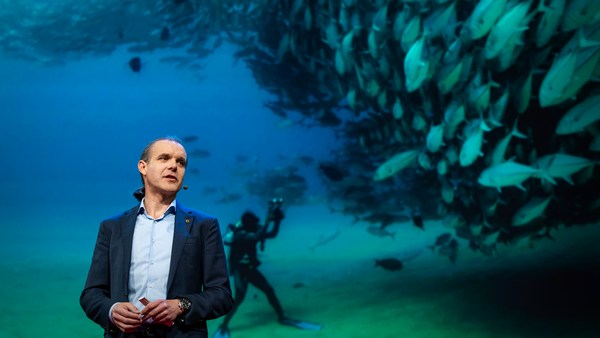
We know more about other planets than our own, and today, I want to show you a new type of robot designed to help us better understand our own planet. It belongs to a category known in the oceanographic community as an unmanned surface vehicle, or USV. And it uses no fuel. Instead, it relies on wind power for propulsion. And yet, it can sail around the globe for months at a time. So I want to share with you why we built it, and what it means for you.
Mes žinome daugiau apie kitas planetas, nei apie savo Žemę, ir šiandien aš noriu jums parodyti naujo tipo robotą, kuris buvo specialiai sukurtas, kad padėtų mums pažinti savo planetą. Jis priklauso katergorijai, kurią okeanografai vadina nepilotuojamos jūrų transporto priemonės (angl. USV). Ir šiam robotui nereikia kuro. Vietoje to, robotas yra varomas vėjo jėga. Tačiau nepaisant to, jis gali mėnesiais plaukioti aplink pasaulį. Noriu jums papasakoti kodėl mes nusprendėm jį sukonstruoti ir kodėl tai jums gali rūpėti.
A few years ago, I was on a sailboat making its way across the Pacific, from San Francisco to Hawaii. I had just spent the past 10 years working nonstop, developing video games for hundreds of millions of users, and I wanted to take a step back and look at the big picture and get some much-needed thinking time. I was the navigator on board, and one evening, after a long session analyzing weather data and plotting our course, I came up on deck and saw this beautiful sunset. And a thought occurred to me: How much do we really know about our oceans? The Pacific was stretching all around me as far as the eye could see, and the waves were rocking our boat forcefully, a sort of constant reminder of its untold power. How much do we really know about our oceans? I decided to find out.
Prieš keletą metų man teko keliauti Ramiuoju vandenynu burinėje valtyje iš San Francisko į Havajus. Aš buvau ką tik praleidęs 10 metų be perstojo dirbdamas, kurdamas videožaidimus šimtams milijonų vartotojų, norėjau trumpam sustoti ir pažvelgti į bendrą vaizdą taip pat leisti sau ramiai viską apgalvoti. Aš buvau laivo navigatorius, ir vieną vakarą po ypač ilgos orų analizės ir kurso krypties planavimo, užlipau and denio ir pamačiau yapč nuostabų saulėlydį. Man iškilo klausimas: kiek iš tikrųjų mes žinome apie savo planetos vandenynus? Aplink mane kur bepažiūrėsi tęsėsi Ramusis vandenynas o bangos valingai siūbavo mūsų laivą, kaip pastovus priminimas apie neapsakytą vandenyno galybę. Kiek iš tikrųjų mes žinome apie savo planetos vandenynus? Nusprendžiau sužinoti.
What I quickly learned is that we don't know very much. The first reason is just how vast oceans are, covering 70 percent of the planet, and yet we know they drive complex planetary systems like global weather, which affect all of us on a daily basis, sometimes dramatically. And yet, those activities are mostly invisible to us.
Ir labai greitai supratau, kad iš tikrųjų mes labai daug nežinome. Pirmiausia mums kiša koją milžiniškas vandenynų dydis; vanduo dengia 70% mūsų planetos ir mes žinome, kad jie yra painių planetos sistemų kaip pasaulio orai varomoji jėga, ir tai veikia mūsų kasdienybę kartais labai dramatiškai. Tačiau, ta vandenyno veikla mums yra beveik nematoma.
Ocean data is scarce by any standard. Back on land, I had grown used to accessing lots of sensors -- billions of them, actually. But at sea, in situ data is scarce and expensive. Why? Because it relies on a small number of ships and buoys. How small a number was actually a great surprise. Our National Oceanic and Atmospheric Administration, better known as NOAA, only has 16 ships, and there are less than 200 buoys offshore globally. It is easy to understand why: the oceans are an unforgiving place, and to collect in situ data, you need a big ship, capable of carrying a vast amount of fuel and large crews, costing hundreds of millions of dollars each, or, big buoys tethered to the ocean floor with a four-mile-long cable and weighted down by a set of train wheels, which is both dangerous to deploy and expensive to maintain.
Kaip bepažiūrėtume, duomenų apie vandenynus stokojame. Sausumoje, aš buvau pripratęs naudotis daugybe jutiklių, iš tiesų, milijardais jutiklių. Bet jūroje gauti <i>in situ</i> duomenis yra reta ir brangu. Kodėl? Nes duomenų rinkimui pagrinde yra naudojami laivai ir bujos. Jų skaičius mane nemaloniai nustebino. Mūsų Nacionalinė Okeanijos ir Atmosferos Administracija, trumpinamama NOAA, turi tik 16 laivų, o bujų atviroje jūroje pasauliniu mastu yra tik 200. Lengva suprasti kodėl: vandenynas yra nedovanojanti vieta, kad surinktume <i>in situ</i> informaciją reikalingas didelis laivas, galintis transportuoti didelį kiekį kuro ir su didele įgula, kurių kiekvienas kainuoja milijonus dolerių. Arba gali naudoti didelius bujus, jūros dugne pritvirtintus 6,5 km ilgio lynu, ir nusvertus naudojantis pora traukinio ratų, visa tai yra sudėtinga dislokuoti ir brangu eksplotuoti.
What about satellites, you might ask? Well, satellites are fantastic, and they have taught us so much about the big picture over the past few decades. However, the problem with satellites is they can only see through one micron of the surface of the ocean. They have relatively poor spatial and temporal resolution, and their signal needs to be corrected for cloud cover and land effects and other factors.
O kaip palydovai žemės orbitoje? Na taip, palydovai yra nuostabūs, ir jie suteikė mums daug žinių apie bendra vaizdą per praėjusius keletą dešimtemčių. Tačiau naudojantis palydovais iškyla keletas problemų: jie mato tik vieną mikroną pačiame vandenyno paviršiuje. Satelitų skiriamoji jėga yra prasta erdvėje ir laike, ir ateinančius signalus reikia nuolat koreguoti dėl debesų, sausumos efektų, ir kitokių faktorių.
So what is going on in the oceans? And what are we trying to measure? And how could a robot be of any use?
Taigi, kas vyksta vandenynuose? Ir ką mes ten bandome matuoti? Ir kuo čia naudingi robotai?
Let's zoom in on a small cube in the ocean. One of the key things we want to understand is the surface, because the surface, if you think about it, is the nexus of all air-sea interaction. It is the interface through which all energy and gases must flow. Our sun radiates energy, which is absorbed by oceans as heat and then partially released into the atmosphere. Gases in our atmosphere like CO2 get dissolved into our oceans. Actually, about 30 percent of all global CO2 gets absorbed. Plankton and microorganisms release oxygen into the atmosphere, so much so that every other breath you take comes from the ocean.
Pažiūrėkime iš arti į mažą vandenyno kubelį. Vienas iš esminių dalykų, kuriuos mes norime suprasti yra paviršius, nes gerai pagalvojus paviršius tai yra kur jūra ir oras sąveikauja tarpusavyje. Tai yra ta sandūra, kuria juda energija ir dujos. Mūsų Saulė spinduliuoja energiją, kurią šilumos pavidalu sugeria vandenynai, o tada palaipsniui išleidžia ją į atmosferą. Mūs atmosferos dujos, pavyzdžiui anglies dvideginis, ištirpsta vandenynuose. Iš tiesų, maždaug 30% viso anglies dvideginio yra sugeriama. Planktonas ir įvairūs mikroorganizmai išleidžia deguonį į atmosferą, tas kiekis toks didelis, kad kas antras mūsų įkvėpimas yra kilęs iš vandenyno.
Some of that heat generates evaporation, which creates clouds and then eventually leads to precipitation. And pressure gradients create surface wind, which moves the moisture through the atmosphere. Some of the heat radiates down into the deep ocean and gets stored in different layers, the ocean acting as some kind of planetary-scale boiler to store all that energy, which later might be released in short-term events like hurricanes or long-term phenomena like El Niño. These layers can get mixed up by vertical upwelling currents or horizontal currents, which are key in transporting heat from the tropics to the poles. And of course, there is marine life, occupying the largest ecosystem in volume on the planet, from microorganisms to fish to marine mammals, like seals, dolphins and whales.
Dalis sugertos šilumos sukelia vandens garavimą, o tai formuoja debesis. Galų gale tai pavirsta krituliais. Oro slėgio skirtumai, suformuoja vėjus, kurie cirkuliuodami po atmosferą kartu nešioja drėgmę, Dalis sugertos šilumos nusklinda iki pat vandenyno gilumos ir yra išsaugoma skirtinguose sluoksniuose, Čia vandenynas veikia kaip planetos dydžio boileris, sulaikydamas atsklidusią energiją, kuri vėliau gali būti išleista trumpalaikiais fenomenais kaip uraganai arba ilgalaikiais kaip El Ninjo. Jūrų sluoksnius gali sumaišyti vertikalios apvelingo srovės, arba horizontalios srovės, kurios yra ypač svarbios pernešant karštą orą iš tropinių regionų į planetos ašigalius. Ir žinoma privalome paminėti jūrinę gyvūniją, mūsų planetoje tai yra didžiausios apimties ekosistema, tai mikroorganizmai, žuvys ir jūriniai žinduoliai pavyzdžiui ruoniai, delfinai ir banginiai.
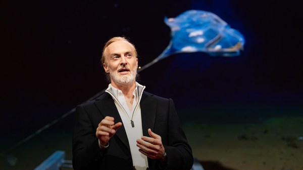
But all of these are mostly invisible to us. The challenge in studying those ocean variables at scale is one of energy, the energy that it takes to deploy sensors into the deep ocean. And of course, many solutions have been tried -- from wave-actuated devices to surface drifters to sun-powered electrical drives -- each with their own compromises. Our team breakthrough came from an unlikely source -- the pursuit of the world speed record in a wind-powered land yacht. It took 10 years of research and development to come up with a novel wing concept that only uses three watts of power to control and yet can propel a vehicle all around the globe with seemingly unlimited autonomy. By adapting this wing concept into a marine vehicle, we had the genesis of an ocean drone.
Tačiau visi šie gyviai mums yra beveik nematomi. Didžiausias iššūkis norint suprasti šiuos vandenyno kintamuosius yra energija. Energija, kuri reikalinga jutiklių dislo- kavimui po vandenyno gelmes. Žinoma, daugybė įvairių idėjų jau buvo išbandyta: bangomis stimuliuojami įrenginiai ir pasroviui plaukiantys ir saulės energija varomi elektriniai įrenginiai; kiekvienas su savo bėdomis. Mūsų komandos proveržis atėjo iš labai netikėto šaltinio – siekiant pasaulio greičio rekordo plaukiant vėjo varoma jachta. Užtrukome 10 metų tyrinėjimams ir bandymams, kad sukurtume naujovišką sparno koncepciją, kuriam kontroliuoti sunaudojame tik 3 vatus energijos, bet jos užtenka mūsų transporto priemonei judėti po visą pasaulį su tarsi neribota autonomija. Pritaikydami šią sparno konstrukciją jūrinei transporto priemonei, mes pagimdėme jūros drono idėją.
Now, these are larger than they appear. They are about 15 feet high, 23 feet long, seven feet deep. Think of them as surface satellites. They're laden with an array of science-grade sensors that measure all key variables, both oceanographic and atmospheric, and a live satellite link transmits this high-resolution data back to shore in real time. Our team has been hard at work over the past few years, conducting missions in some of the toughest ocean conditions on the planet, from the Arctic to the tropical Pacific. We have sailed all the way to the polar ice shelf. We have sailed into Atlantic hurricanes. We have rounded Cape Horn, and we have slalomed between the oil rigs of the Gulf of Mexico. This is one tough robot.
Iš tiesų jie yra didesni nei atrodo. Maždaug 4,5 m aukščio, 7 m ilgio ir 2 m gylio. Įsivaizduokite juos kaip paviršiaus palydovus. Kiekvienas jų turi mokslinio lygmens jutiklių komplektą, kuriuo matuojami įvairiausi kintamieji okeanografiniai ir atmosferiniai. Tiesoginė palydovinė sąsaja, įgalina aukštos kokybės duomenų perdavimą iš jūros atgal į krantą realiuoju laiku. Per paskutinius keletą metų mūsų komanda labai stipriai dirbo atlikdami užduotis atšiauriausiuose mūsų planetos vandenynų kampeliuose nuo Arkties iki pat tropinio Ramiojo vandenyno Mes plaukėme prie pat poliarinių ledynų. Mes plaukėme į Atlante siaučiančius uraganus. Mes apsukome aplink Horno Ragą, ir vingiavome tarp naftos bokštų Meksikos įlankoje, Tai vienas ištvermingiausių robotų.
Let me share with you recent work that we did around the Pribilof Islands. This is a small group of islands deep in the cold Bering Sea between the US and Russia. Now, the Bering Sea is the home of the walleye pollock, which is a whitefish you might not recognize, but you might likely have tasted if you enjoy fish sticks or surimi. Yes, surimi looks like crabmeat, but it's actually pollock. And the pollock fishery is the largest fishery in the nation, both in terms of value and volume -- about 3.1 billion pounds of fish caught every year.
Leiskite su jumis pasidalinti naujausias mūsų atradimais iš Pribilof salų. Tai nedidelė salų grupė toli šaltoje Beringo jūroje tarp Jungtinių Valstijų ir Rusijos. Beringo jūroje gyvena aliaskinė rudagalvė menkė, tai yra baltamėsė žuvis, bet net jei jos neatpažįstate, greičiausiai esate jos ragavę, jei kada esate valge žuvų pirštelių ar surimio. Taip, surimis atrodo kaip krabų mėsa, bet iš tikrųjų tai aliaskinė menkė. Šių menkių žūklė yra didžiausia šalyje kalbant apie jos vertę ir dydį – maždaug 14 milijardų kg šios žuvies yra sugaunama kiekvienais metais.
So over the past few years, a fleet of ocean drones has been hard at work in the Bering Sea with the goal to help assess the size of the pollock fish stock. This helps improve the quota system that's used to manage the fishery and help prevent a collapse of the fish stock and protects this fragile ecosystem. Now, the drones survey the fishing ground using acoustics, i.e., a sonar. This sends a sound wave downwards, and then the reflection, the echo from the sound wave from the seabed or schools of fish, gives us an idea of what's happening below the surface. Our ocean drones are actually pretty good at this repetitive task, so they have been gridding the Bering Sea day in, day out.
Taigi per keletą pastarųjų metų flotilė vandenyno dronų leido laiką Beringo jūroje, kad galėtume įvertinti aliaskinių rudagalvių menkių populiaciją. Ši informacija padeda nustatyti teisingas žuvininkystės kvotas, kurios neleistų žlugti šios žuvies atsargoms, ir padėtų apsaugoti šią trapią ekosistemą. Žvejybos plotus dronai žvalgo naudojantis akustika – sonaru. Sonaras nusiunčia garso bangą žemyn, tada sugrįžtantis atspindys (garso bangos atgarsis) nuo jūros dugno, ar žuvų būrio, leidžia susidaryti vaizdą apie tai kas vyksta po vandeniu. Mūsų vandenyno dronai yra labai tinkami šiai pasikartojančiai užduočiai, todėl jie diena iš dienos analizuoja kiekvieną Beringo jūros kvadratėlį.
Now, the Pribilof Islands are also the home of a large colony of fur seals. In the 1950s, there were about two million individuals in that colony. Sadly, these days, the population has rapidly declined. There's less than 50 percent of that number left, and the population continues to fall rapidly. So to understand why, our science partner at the National Marine Mammal Laboratory has fitted a GPS tag on some of the mother seals, glued to their furs. And this tag measures location and depth and also has a really cool little camera that's triggered by sudden acceleration. Here is a movie taken by an artistically inclined seal, giving us unprecedented insight into an underwater hunt deep in the Arctic, and the shot of this pollock prey just seconds before it gets devoured.
Pribilof salose gyvena gana didelė kotikų kolonija. 1950-aisiais toje kolonijoje gyveno apie 2 milijonai individų. Deja šiandien jų populiacija yra žymiai sumažėjusi. Kotikų yra likę mažiau nei 50 procentų. ir jų populiacija toliau sparčiai mažėja. Kad suprastume kodėl tai vyksta, mūsų moksliniai partneriai iš Nacionalinės Jūrų Žinduolių Laboratorijos, prie keleto kotikų motinų kailių priklijavo GPS etiketes. Tokia etiketė matuoja vietą ir gylį, prie jos yra ir maža kamerytė, kuri pradeda įrašinėti po staigios akseleracijos. Štai filmas, kurį sukūrė vienas labai meniškas kotikas. Tai beprecedentis žvilgsnis į povandeninę medžioklę giliai arktyje, o šiame kadre kotiko grobis - menkė, kelios sekundės prieš praryjant.
Now, doing work in the Arctic is very tough, even for a robot. They had to survive a snowstorm in August and interferences from bystanders -- that little spotted seal enjoying a ride.
Dirbti arktyje yra labai sunku, net ir robotams. Dronai turėjo išgyventi Rugpjūčio pūgą, pašalinių kišimąsi, dėmėtojo ruonio jauniklis mėgaujasi pasivažinėjimu.
(Laughter)
(Juokas)
Now, the seal tags have recorded over 200,000 dives over the season, and upon a closer look, we get to see the individual seal tracks and the repetitive dives. We are on our way to decode what is really happening over that foraging ground, and it's quite beautiful. Once you superimpose the acoustic data collected by the drones, a picture starts to emerge. As the seals leave the islands and swim from left to right, they are observed to dive at a relatively shallow depth of about 20 meters, which the drone identifies is populated by small young pollock with low calorific content. The seals then swim much greater distance and start to dive deeper to a place where the drone identifies larger, more adult pollock, which are more nutritious as fish. Unfortunately, the calories expended by the mother seals to swim this extra distance don't leave them with enough energy to lactate their pups back on the island, leading to the population decline. Further, the drones identify that the water temperature around the island has significantly warmed. It might be one of the driving forces that's pushing the pollock north, and to spread in search of colder regions. So the data analysis is ongoing, but already we can see that some of the pieces of the puzzle from the fur seal mystery are coming into focus.
Vieno sezono metu, GPS etiketės užfiksavo 200 000 nėrimų, ir pažiūrėjus iš arčiau mes galime sekti individualius kotikus, ir jų pasikartojančius nardymus. Mes palaipsniui aiškinamės kas iš tikrųjų vyksta ieškant maisto tose vietovėse, ir tai visai gražus procesas Sujungiant visą dronų surinktą akustinę medžiagą galima susidaryti gana gerą bendrą vaizdą. Palikę salą kotikai plaukioja kairėn ir dešinėn, matome, kad jie paneria gana negiliai, maždaug į 20 metrų gylį, ten, kur drono duomenimis, yra daug mažų aliaskinių rudagalvių menkių jauniklių. turinčių žemą kalorijų kiekį. Tada kotikai plaukia daug didesnius atstumus, ir pradeda nerti giliau, kur drono duomenimis, yra daugiau didesnių suaugusių menkių, kurios yra daug maistingesnės. Deja, plaukdamos tokį didelį atstumą kotikų motinos išnaudoja labai daug kalorijų, todėl joms nebelieka energijos jaunikliams išmaitinti, kas nulemia populiacijos smukimą. Naudodamiesi dronais mes taip pat pastebė- jome, kad aplink salą rimtai kyla vandens temperatūra. Turbūt tai vienas iš faktorių verčiančių menkių populiacijos judėjimą šiaurėn, kur temperatūra yra žemesnė. Mūsų tyrimai tęsiasi, bet jau dabar aiškėja svarbios detalės iš paslaptingo kotikų gyvenimo.
But if you look back at the big picture, we are mammals, too. And actually, the oceans provide up to 20 kilos of fish per human per year. As we deplete our fish stocks, what can we humans learn from the fur seal story? And beyond fish, the oceans affect all of us daily as they drive global weather systems, which affect things like global agricultural output or can lead to devastating destruction of lives and property through hurricanes, extreme heat and floods. Our oceans are pretty much unexplored and undersampled, and today, we still know more about other planets than our own.
Tačiau truputį apsižvalgius, juk mes taip pat esame žinduoliai. Vendenynai kiekvieną žmogų aprūpina 20-čia kilgoramų žuvies per metus. Mums beeikvojant savo žuvų atsargas, ko žmonės galėtų pasimokyti iš kotikų istorijos? Vandenynai mūsų kasdienybę paveikia ir nepaisant žuvies, globaliai paveikdami klimato sistemas, kurios lemia visuotinę žemės ūkio produkciją. Taip pat jie gali suniokoti nuosavybę ir pareikalauti žmonių gyvybių per uraganus, kaitras, sausras ar potvynius. Planetos vandenynai yra faktiškai neištirti, ir šiandien mes vis dar žinome daugiau apie kitas planetas nei apie savąją.
But if you divide this vast ocean in six-by-six-degree squares, each about 400 miles long, you'd get about 1,000 such squares. So little by little, working with our partners, we are deploying one ocean drone in each of those boxes, the hope being that achieving planetary coverage will give us better insights into those planetary systems that affect humanity.
Padalinus mūsų neaprėpiamus vandenynys, į 6 laipsnių kvadratus kiekvienas iš jų maždaug 600 kilometrų ilgio, gautume maždaug tūkstantį tokių kvadratėlių. Taigi po truputį, bendradarbiaudami su partneriais mes dislokuojame jūros dronus į kiekvieną iš tų kvadratėlių, tikėdamiesi, kad aprėpę visą planetą mes įžvelgsime svarbias planetos lygio sistemas, kurios veikia visą žmoniją.
We have been using robots to study distant worlds in our solar system for a while now. Now it is time to quantify our own planet, because we cannot fix what we cannot measure, and we cannot prepare for what we don't know.
Mes jau ilgą laiką naudojamės robotais tyrinėdami tolimus pasaulius mūsų saulės sistemoje. Atėjo laikas išmatuoti ir įvertinti savo planetą, nes mes negalime sutaisyti, ko negalime pamatuoti; ir negalime pasiruošti tam, apie ką nežinome.
Thank you.
Ačiū jums.
(Applause)
(Plojimai)