We know more about other planets than our own, and today, I want to show you a new type of robot designed to help us better understand our own planet. It belongs to a category known in the oceanographic community as an unmanned surface vehicle, or USV. And it uses no fuel. Instead, it relies on wind power for propulsion. And yet, it can sail around the globe for months at a time. So I want to share with you why we built it, and what it means for you.
Többet tudunk más bolygókról, mint a sajátunkról, és ma olyan újfajta robotot szeretnék bemutatni, amelyet arra terveztek, hogy segítsen jobban megérteni a bolygónkat. Olyan kategóriába tartozik, melyet az oceanográfiában tengerfelszíni kutatórobotként, USV-ként ismernek. Nem üzemanyaggal működik. Helyette szélenergia hajtja. Mégis körbehajózza a bolygót hónapokon át. Elmondom, miért építettük meg, és mit jelent az önök számára.
A few years ago, I was on a sailboat making its way across the Pacific, from San Francisco to Hawaii. I had just spent the past 10 years working nonstop, developing video games for hundreds of millions of users, and I wanted to take a step back and look at the big picture and get some much-needed thinking time. I was the navigator on board, and one evening, after a long session analyzing weather data and plotting our course, I came up on deck and saw this beautiful sunset. And a thought occurred to me: How much do we really know about our oceans? The Pacific was stretching all around me as far as the eye could see, and the waves were rocking our boat forcefully, a sort of constant reminder of its untold power. How much do we really know about our oceans? I decided to find out.
Néhány évvel ezelőtt vitorláshajón utaztam keresztül a Csendes-óceánon, San Franciscóból Hawaiira. Az elmúlt 10 évet folyamatos munkával töltöttem. Videojátékokat fejlesztettem felhasználók millióinak, és szerettem volna lehiggadni, egészében látni a dolgokat, és elgondolkozni. A hajó navigátora voltam, és egy este, miután hosszasan elemeztük az időjárási adatokat, és útvonalunkat vittük térképre, a fedélzetre érve ezt a gyönyörű naplementét láttam. Belém hasított a gondolat: Mennyit tudunk valójában az óceánjainkról? A Csendes-óceán ott terült el előttem, míg a szem ellát, és a hullámok erőteljesen csapkodták a hajónkat, állandóan emlékeztetve hatalmas erejükre. Mennyit tudunk valójában az óceánjainkról? Úgy döntöttem, kiderítem.
What I quickly learned is that we don't know very much. The first reason is just how vast oceans are, covering 70 percent of the planet, and yet we know they drive complex planetary systems like global weather, which affect all of us on a daily basis, sometimes dramatically. And yet, those activities are mostly invisible to us.
Hamar rájöttem, hogy nem sokat. Ennek egyik oka, hogy az óceánok hatalmasak, a Föld 70%-át borítják, de tudjuk, hogy komplex rendszereket irányítanak, pl. bolygónk időjárását, ami hatással van ránk nap mint nap, olykor drámaian. Mégis, ezek a folyamatok számunkra nagyrészt láthatatlanok.
Ocean data is scarce by any standard. Back on land, I had grown used to accessing lots of sensors -- billions of them, actually. But at sea, in situ data is scarce and expensive. Why? Because it relies on a small number of ships and buoys. How small a number was actually a great surprise. Our National Oceanic and Atmospheric Administration, better known as NOAA, only has 16 ships, and there are less than 200 buoys offshore globally. It is easy to understand why: the oceans are an unforgiving place, and to collect in situ data, you need a big ship, capable of carrying a vast amount of fuel and large crews, costing hundreds of millions of dollars each, or, big buoys tethered to the ocean floor with a four-mile-long cable and weighted down by a set of train wheels, which is both dangerous to deploy and expensive to maintain.
Az óceánokra vonatkozó adatok minden szempontból elégtelenek. Szárazföldön hozzászoktam, hogy sok érzékelőhöz férek hozzá – valójában több milliárdhoz. De a tengeren a helyi adatok ritkák és drágák. Miért? Mert mennyiségük a kevés hajótól és bójától függ. Hogy mennyire kevés, az meglepő volt. A Nemzeti Óceán- és Légkörhivatal, azaz a NOAA csak 16 hajóval rendelkezik, és a partok mentén az egész Földön csak kevesebb mint 200 bója van. Ennek egyszerű az oka: az óceán engesztelhetetlen hely, helyi adatok gyűjtéséhez nagy hajó kell, mely sok üzemanyagot és nagyszámú legénységet képes szállítani. Mindegyik több millió dollárba kerül, vagy a tengerfenékhez hat km-es kábellel kipányvázott, vonatkerekekkel lehorgonyzott nagy bóják, amelyeket veszélyes telepíteni, és költséges fenntartani.
What about satellites, you might ask? Well, satellites are fantastic, and they have taught us so much about the big picture over the past few decades. However, the problem with satellites is they can only see through one micron of the surface of the ocean. They have relatively poor spatial and temporal resolution, and their signal needs to be corrected for cloud cover and land effects and other factors.
Mi a helyzet a műholdakkal? – kérdezhetik. A műholdak fantasztikusak, és nagyon sokat megmutattak az összképből az elmúlt évtizedek alatt. De az a baj a műholdakkal, hogy az óceán felszínétől egy mikronnyira látnak le. Viszonylag gyenge a térbeli és időbeli felbontásuk, és a jelük javításra szorul felhők, földi hatások és egyéb tényezők miatt.
So what is going on in the oceans? And what are we trying to measure? And how could a robot be of any use?
Mi történik tehát az óceánokban, és mit próbálunk megmérni? Mi hasznát vesszük egy robotnak?
Let's zoom in on a small cube in the ocean. One of the key things we want to understand is the surface, because the surface, if you think about it, is the nexus of all air-sea interaction. It is the interface through which all energy and gases must flow. Our sun radiates energy, which is absorbed by oceans as heat and then partially released into the atmosphere. Gases in our atmosphere like CO2 get dissolved into our oceans. Actually, about 30 percent of all global CO2 gets absorbed. Plankton and microorganisms release oxygen into the atmosphere, so much so that every other breath you take comes from the ocean.
Koncentráljunk az óceán egy kis kockájára! Az egyik megértendő kulcskérdés a felszín, mert a felszín, ha belegondolunk, a kapocs a levegő és tenger közötti minden kölcsönhatásban. Minden energia és gáz e felületen keresztül áramlik. Napunk energiát sugároz, amit hőként nyel el az óceán, majd részben a légkörbe bocsátja. A légkörünkben lévő gázok, pl. a CO₂, az óceánokba oldódnak. Az összes CO₂ kb. 30%-a oldódik be. A planktonok és mikroorganizmusok annyi oxigént engednek a légkörbe, hogy minden második levegővételünk az óceánból származik.
Some of that heat generates evaporation, which creates clouds and then eventually leads to precipitation. And pressure gradients create surface wind, which moves the moisture through the atmosphere. Some of the heat radiates down into the deep ocean and gets stored in different layers, the ocean acting as some kind of planetary-scale boiler to store all that energy, which later might be released in short-term events like hurricanes or long-term phenomena like El Niño. These layers can get mixed up by vertical upwelling currents or horizontal currents, which are key in transporting heat from the tropics to the poles. And of course, there is marine life, occupying the largest ecosystem in volume on the planet, from microorganisms to fish to marine mammals, like seals, dolphins and whales.
A hő egy része párolgást okoz, amiből felhők lesznek, és ez végül csapadékhoz vezet. A levegő nyomásváltozása felszíni szelet okoz, ami a páratartalmat mozgatja a légkörben. A hő egy része az óceán mélyéig sugároz, és különböző rétegekben raktározódik el. Az óceán mint bolygóméretű melegvíztároló raktározza el az összes energiát, amely később rövidtávú események, pl. hurrikánok során, vagy hosszútávú jelenségként, mint az El Niño, szabadul fel. E rétegek függőleges felszálló áramlás vagy vízszintes áramlatok révén keveredhetnek; ezek a trópusoktól a sarkok felé irányuló hőátadás fontos elemei. És persze van tengeri élet, ami bolygónk legnagyobb ökorendszere, és a mikroorganizmusoktól, a halaktól a tengeri emlősökig, pl. fókákig, delfinekig s bálnákig terjed.
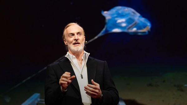
But all of these are mostly invisible to us. The challenge in studying those ocean variables at scale is one of energy, the energy that it takes to deploy sensors into the deep ocean. And of course, many solutions have been tried -- from wave-actuated devices to surface drifters to sun-powered electrical drives -- each with their own compromises. Our team breakthrough came from an unlikely source -- the pursuit of the world speed record in a wind-powered land yacht. It took 10 years of research and development to come up with a novel wing concept that only uses three watts of power to control and yet can propel a vehicle all around the globe with seemingly unlimited autonomy. By adapting this wing concept into a marine vehicle, we had the genesis of an ocean drone.
De ezek nagyrészt láthatatlanok számunkra. Az óceán változóinak tanulmányozásában az egyik nehézség az energia, amely érzékelőknek az óceán mélyébe merítéséhez szükséges. Persze, sok megoldást próbáltak már – hullám működtette eszközöktől a vízfelszíni járművekig, a napelemes eszközökig – mind a maga kompromisszumával. A csapatunk áttörése meglepő forrásból jött: szélhajtású jachtokkal folytatott gyorsaságirekord-versenyből. Tízévnyi kutatásba és fejlesztésbe került, hogy újféle szárnyat tervezzünk, ami csak három wattot használ az irányításhoz és látszólag korlátlan autonómiájú járművet is tud hajtani az egész bolygón át. Ezt a szárnyat tengeri járműre alkalmazva óceáni drón keletkezett.
Now, these are larger than they appear. They are about 15 feet high, 23 feet long, seven feet deep. Think of them as surface satellites. They're laden with an array of science-grade sensors that measure all key variables, both oceanographic and atmospheric, and a live satellite link transmits this high-resolution data back to shore in real time. Our team has been hard at work over the past few years, conducting missions in some of the toughest ocean conditions on the planet, from the Arctic to the tropical Pacific. We have sailed all the way to the polar ice shelf. We have sailed into Atlantic hurricanes. We have rounded Cape Horn, and we have slalomed between the oil rigs of the Gulf of Mexico. This is one tough robot.
Ezek nagyobbak, mint amekkorának tűnnek. Kb. öt méter magasak, hét méter hosszúak, két méter szélesek. Felszíni műholdként gondoljanak rájuk. Tudományos minőségű érzékelőkkel vannak ellátva, melyek fontos oceanográfiai és légköri változókat mérnek, és élő műholdas kapcsolat továbbítja e nagy felbontású adatokat a partra, valós időben. Csapatunk szorgalmasan dolgozott az elmúlt években, bevetéseket irányított olykor a legkeményebb óceáni körülmények között a bolygón, az Északi-sarkvidéktől a csendes-óceáni térségig. Vitorláztunk a sarki jégsapkáknál. Vitorláztunk az Atlanti-óceáni hurrikánokban. Megkerültük a Horn-fokot, és a Mexikói-öböl olajfúró tornyai között szlalomoztunk. Ez egy kemény robot.
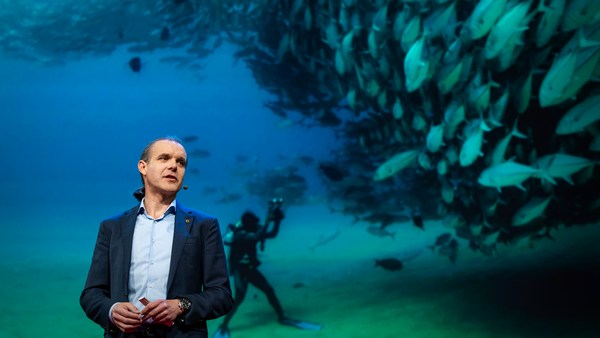
Let me share with you recent work that we did around the Pribilof Islands. This is a small group of islands deep in the cold Bering Sea between the US and Russia. Now, the Bering Sea is the home of the walleye pollock, which is a whitefish you might not recognize, but you might likely have tasted if you enjoy fish sticks or surimi. Yes, surimi looks like crabmeat, but it's actually pollock. And the pollock fishery is the largest fishery in the nation, both in terms of value and volume -- about 3.1 billion pounds of fish caught every year.
Hadd beszéljek a Pribilof-szigetek táján végzett egyik legutóbbi munkánkról. Ez az apró szigetcsoport a hideg Bering-tenger közepén terül el, az USA és Oroszország között. A Bering-tenger az alaszkai tőkehal hazája, mely fehér húsú hal, talán nem ismernék fel, de tán kóstolták, ha szeretik a halrudacskákat vagy a surimit. A surimi ráknak néz ki, de valójában tőkehal. A tőkehalászat a nép legnagyobb halgazdasága, érték- és mennyiségi szempontból is. 1,4 millió tonna halat fognak ki évente.
So over the past few years, a fleet of ocean drones has been hard at work in the Bering Sea with the goal to help assess the size of the pollock fish stock. This helps improve the quota system that's used to manage the fishery and help prevent a collapse of the fish stock and protects this fragile ecosystem. Now, the drones survey the fishing ground using acoustics, i.e., a sonar. This sends a sound wave downwards, and then the reflection, the echo from the sound wave from the seabed or schools of fish, gives us an idea of what's happening below the surface. Our ocean drones are actually pretty good at this repetitive task, so they have been gridding the Bering Sea day in, day out.
Az elmúlt években óceáni drónok hada dolgozott a Bering-tengeren, hogy tájékoztasson a tőkehalállomány méretéről. Ez elősegíti a halászatot szabályozó kvótarendszer fejlesztését, segít megelőzni a halállomány összeomlását, és védi ezt az érzékeny ökorendszert. A drónok akusztikus úton mérik fel a halászterületet, azaz hanglokátorral. Ez hanghullámot küld lefele, majd a hanghullám keltette, a tengerfenékről vagy a halakról visszaverődő visszhangból fogalmat alkothatunk arról, mi történik a felszín alatt. Óceáni drónjaink elég jók ebben az ismétlődő feladatban, így nap mint nap a Bering-tengert térképezték fel.
Now, the Pribilof Islands are also the home of a large colony of fur seals. In the 1950s, there were about two million individuals in that colony. Sadly, these days, the population has rapidly declined. There's less than 50 percent of that number left, and the population continues to fall rapidly. So to understand why, our science partner at the National Marine Mammal Laboratory has fitted a GPS tag on some of the mother seals, glued to their furs. And this tag measures location and depth and also has a really cool little camera that's triggered by sudden acceleration. Here is a movie taken by an artistically inclined seal, giving us unprecedented insight into an underwater hunt deep in the Arctic, and the shot of this pollock prey just seconds before it gets devoured.
A Priblof-szigetek szintén a medvefókák hatalmas kolóniájának otthona. 1950-ben kb. kétmillió egyede volt a kolóniának. Sajnos, napjainkban a populáció jelentősen csökkent. Kevesebb mint 50%-uk maradt, és a populáció továbbra is gyorsan fogy. Hogy megértsük, miért, tudományos partnerünk a Nemzeti Tengeriemlős-laboratóriumban GPS-nyomkövetőt rögzített néhány anyafóka bundájára. Ezek a nyomkövetők mérik a helyzetet és a mélységet és van egy remek apró kamerájuk is, ami a hirtelen gyorsulásra reagál. Itt egy film egy művészi hajlamú fókától, amely példátlan betekintést enged az Északi-sarkvidéken folyó víz alatti vadászatba, a felvételen a tőkehal a zsákmány, pillanatokkal a felfalása előtt.
Now, doing work in the Arctic is very tough, even for a robot. They had to survive a snowstorm in August and interferences from bystanders -- that little spotted seal enjoying a ride.
A Sarkvidéken végzett munka még egy robotnak is nagyon kemény. Túl kellett élniük augusztusi hóvihart és bámészkodók zavaró hatását – az a kicsi pöttyös fóka élvezi az utat.
(Laughter)
(Nevetés)
Now, the seal tags have recorded over 200,000 dives over the season, and upon a closer look, we get to see the individual seal tracks and the repetitive dives. We are on our way to decode what is really happening over that foraging ground, and it's quite beautiful. Once you superimpose the acoustic data collected by the drones, a picture starts to emerge. As the seals leave the islands and swim from left to right, they are observed to dive at a relatively shallow depth of about 20 meters, which the drone identifies is populated by small young pollock with low calorific content. The seals then swim much greater distance and start to dive deeper to a place where the drone identifies larger, more adult pollock, which are more nutritious as fish. Unfortunately, the calories expended by the mother seals to swim this extra distance don't leave them with enough energy to lactate their pups back on the island, leading to the population decline. Further, the drones identify that the water temperature around the island has significantly warmed. It might be one of the driving forces that's pushing the pollock north, and to spread in search of colder regions. So the data analysis is ongoing, but already we can see that some of the pieces of the puzzle from the fur seal mystery are coming into focus.
A fókamegfigyelők több mint 200 000 merülést rögzítettek az évszakban, és ha jobban megnézzük, látjuk az egyedi számokat és az ismétlődő merüléseket. Folyamatosan dekódoljuk, mi történik e vadászterületeken, és ez gyönyörű. Amikor a drónok gyűjtötte hangadatokat összerakjuk, kirajzolódik a kép. Mikor a fókák elhagyják a szigeteket, és balról jobbra úsznak, látható, hogy viszonylag sekély, 20 méteres mélységbe merülnek, melyben, ahogy a drón mutatja, alacsony kalóriatartalmú, apró, fiatal tőkehalak vannak. Majd távolabbra és mélyebbre úsznak, oda, ahol a drón nagyobb, idősebb, táplálóbb tőkehalakat észlelt. Sajnos, az e hosszú távon felemésztett kalóriák miatt a fókáknak már nem marad elég energiájuk, hogy szoptassák kicsinyeiket a szigeten, így a populáció csökken. Továbbá, a drón jelezte, hogy a víz hőmérséklete a szigetnél jelentősen megnőtt. Talán ez az egyik fő oka annak, ami a tőkehalakat északra űzi, hogy hidegebb régiók után kutassanak. Az adatfeldolgozás folyamatban van, de már látható, hogy a medvefóka-rejtély kirakósának pár darabja már a helyére kerül.
But if you look back at the big picture, we are mammals, too. And actually, the oceans provide up to 20 kilos of fish per human per year. As we deplete our fish stocks, what can we humans learn from the fur seal story? And beyond fish, the oceans affect all of us daily as they drive global weather systems, which affect things like global agricultural output or can lead to devastating destruction of lives and property through hurricanes, extreme heat and floods. Our oceans are pretty much unexplored and undersampled, and today, we still know more about other planets than our own.
De ha az összképet nézzük, mi is emlősök vagyunk. Az óceánok évente akár 20 kiló halat nyújtanak egy-egy embernek. Ahogy kimerítjük a halállományunkat, mit tanulhatunk mi, emberek a medvefókák történetéből? Az óceán a halakon kívül is nap mint nap hatással van ránk a globális időjárási rendszerek révén, ami befolyásolja a világ mezőgazdasági termelését, vagy elpusztítja az életet és a tulajdonunkat hurrikánokkal, árvizekkel és szélsőséges hőmérséklettel. Óceánjaink nagyjából ismeretlenek és felfedezetlenek, és még mindig többet tudunk más bolygókról, mint a sajátunkról.
But if you divide this vast ocean in six-by-six-degree squares, each about 400 miles long, you'd get about 1,000 such squares. So little by little, working with our partners, we are deploying one ocean drone in each of those boxes, the hope being that achieving planetary coverage will give us better insights into those planetary systems that affect humanity.
De ha felosztjuk a hatalmas óceánt 650 km oldalú négyzetekre, nagyjából 1 000 négyzetet kapunk. Így partereinkkel együtt lassacskán minden négyzetbe egy-egy drónt telepítünk, azt remélve, hogy a bolygót lefedve jobban belelátunk a bolygó rendszereibe, melyek hatással vannak az emberiségre.
We have been using robots to study distant worlds in our solar system for a while now. Now it is time to quantify our own planet, because we cannot fix what we cannot measure, and we cannot prepare for what we don't know.
Már jó ideje robotokat használunk naprendszerünk távoli világainak vizsgálatára. Eljött az idő, hogy saját bolygónkat is számba vegyük, mert nem tudunk javítani azon, amit nem tudunk megmérni, és nem tudunk felkészülni arra, amit nem ismerünk.
Thank you.
Köszönöm.
(Applause)
(Taps)