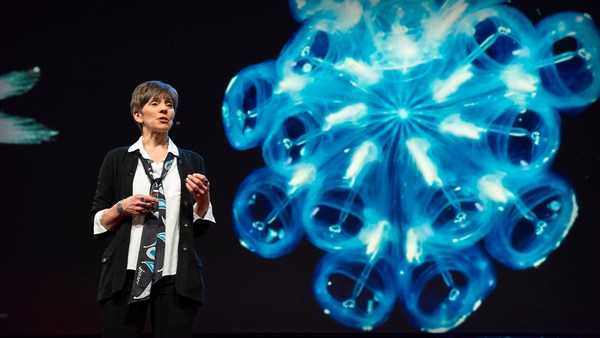
We know more about other planets than our own, and today, I want to show you a new type of robot designed to help us better understand our own planet. It belongs to a category known in the oceanographic community as an unmanned surface vehicle, or USV. And it uses no fuel. Instead, it relies on wind power for propulsion. And yet, it can sail around the globe for months at a time. So I want to share with you why we built it, and what it means for you.
הידע שלנו על כוכבי לכת אחרים רב יותר מהידע על הכוכב שלנו, והיום, אני רוצה להראות לכם סוג חדש של רובוט אשר תוכנן על מנת לעזור לנו להבין טוב יותר את הכוכב שלנו. הוא שייך לקטגוריה הידועה בקרב קהילת האוקיינוגרפים בשם "כלי שייט בלתי מאוייש", או כשב"מ. הוא אינו צורך דלק. במקום זאת, הוא תלוי ברוח ככוח מניע. ועדיין, הוא יכול לשייט מסביב לעולם במשך חודשים ללא תחזוקה. אז אני רוצה לחלוק איתכם את הסיבה בשֵלה בנינו אותו, ומה משמעותו עבורכם.
A few years ago, I was on a sailboat making its way across the Pacific, from San Francisco to Hawaii. I had just spent the past 10 years working nonstop, developing video games for hundreds of millions of users, and I wanted to take a step back and look at the big picture and get some much-needed thinking time. I was the navigator on board, and one evening, after a long session analyzing weather data and plotting our course, I came up on deck and saw this beautiful sunset. And a thought occurred to me: How much do we really know about our oceans? The Pacific was stretching all around me as far as the eye could see, and the waves were rocking our boat forcefully, a sort of constant reminder of its untold power. How much do we really know about our oceans? I decided to find out.
לפני מספר שנים, הייתי על ספינת-מפרש שחצתה את האוקיינוס השקט, מסן-פרנציסקו להוואי. ביליתי את 10 השנים האחרונות, בעבודה בלתי פוסקת, של פיתוח משחקי וידאו עבור מאות מיליוני משתמשים, ורציתי לקחת צעד אחד אחורה ולהסתכל על התמונה הגדולה ולזכות במעט זמן מחשבה נחוץ. הייתי נווט הספינה, וערב אחד, לאחר פרק זמן ארוך של ניתוח נתוני מזג אויר והתוויית מסלול השיט שלנו, עליתי לסיפון וראיתי את השקיעה היפהפיה הזאת. ואז חלפה במוחי מחשבה: כמה באמת אנחנו יודעים על האוקיינוסים שלנו? האוקיינוס השקט היה פרוש סביבי ככל שהעין יכלה לראות, והגלים נענעו את הספינה שלנו בעוצמה, סוג של תזכורת קבועה לעוצמתו הבלתי ניתנת לתאור. כמה אנחנו באמת יודעים על האוקיינוסים? החלטתי למצוא את התשובה.
What I quickly learned is that we don't know very much. The first reason is just how vast oceans are, covering 70 percent of the planet, and yet we know they drive complex planetary systems like global weather, which affect all of us on a daily basis, sometimes dramatically. And yet, those activities are mostly invisible to us.
גיליתי מהר מאוד שאנו לא יודעים הרבה. הסיבה הראשונה לכך היא גודלם העצום של האוקיינוסים, 70 אחוז מפני כדור הארץ, ועם זאת, אנו יודעים שהם מניעים מערכות פלנטריות מורכבות כמו מזג האויר העולמי, אשר משפיע על כולנו על בסיס יומי, לפעמים באופן דרמטי. אך עדיין, הפעילויות האלה לרוב בלתי נראות לעינינו.
Ocean data is scarce by any standard. Back on land, I had grown used to accessing lots of sensors -- billions of them, actually. But at sea, in situ data is scarce and expensive. Why? Because it relies on a small number of ships and buoys. How small a number was actually a great surprise. Our National Oceanic and Atmospheric Administration, better known as NOAA, only has 16 ships, and there are less than 200 buoys offshore globally. It is easy to understand why: the oceans are an unforgiving place, and to collect in situ data, you need a big ship, capable of carrying a vast amount of fuel and large crews, costing hundreds of millions of dollars each, or, big buoys tethered to the ocean floor with a four-mile-long cable and weighted down by a set of train wheels, which is both dangerous to deploy and expensive to maintain.
נתונים מן האוקיינוסים הם מצומצים לפני כל קנה מידה. ביבשה, התרגלתי לכך שיש לי גישה להרבה חיישנים -- מילארדים, למעשה. אבל בים, נתונים שנאספים ישירות ובזמן אמת, הם מצומצמים ויקרים. מדוע? כיוון שהם תלויים במספר קטן של אניות ומצופים. הופתעתי לגלות עד כמה קטן הוא מספר זה. ל"מינהל האוקיינוסים והאטמוספירה הלאומי" האמריקאי, הידוע בשם NOAA, יש רק 16 ספינות, וישנם פחות מ-200 מצופים המרוחקים מן החוף בכל העולם. קל להבין מדוע: האוקיינוסים מהווים סביבה לא סלחנית, וכדי לאסוף מהם נתונים ישירות, נדרשת אניה גדולה, אשר מסוגלת לשאת כמות עצומה של דלק וצוותים גדולים, ועולה מאות מיליוני דולרים, או מצופים גדולים הרתומים לקרקעית האוקיינוס עם כבלים באורך של 6.5 ק"מ המעוגנים בעזרת סדרה של גלגלי רכבת, שהצבתם מסוכנת ותחזוקתם יקרה.
What about satellites, you might ask? Well, satellites are fantastic, and they have taught us so much about the big picture over the past few decades. However, the problem with satellites is they can only see through one micron of the surface of the ocean. They have relatively poor spatial and temporal resolution, and their signal needs to be corrected for cloud cover and land effects and other factors.
מה לגבי לוויינים, אתם עשויים לשאול? ובכן, לוויינים הם נהדרים, והם לימדו אותנו כל כך הרבה על התמונה הגדולה במשך העשורים האחרונים. אבל, הבעיה עם לוויינים, היא שהם יכולים לצפות דרך מיקרון אחד בלבד של פני הים. יש להם רזולוצייה זמנית ומרחבית גרועה יחסית, ואת האותות שלהם צריך לתקן עקב השפעות העננות, הטופוגרפיה, וגורמים נוספים.
So what is going on in the oceans? And what are we trying to measure? And how could a robot be of any use?
אז מה קורה באוקיינוסים? ומה אנחנו מנסים למדוד? ואיך רובוט עשוי לשמש אותנו?
Let's zoom in on a small cube in the ocean. One of the key things we want to understand is the surface, because the surface, if you think about it, is the nexus of all air-sea interaction. It is the interface through which all energy and gases must flow. Our sun radiates energy, which is absorbed by oceans as heat and then partially released into the atmosphere. Gases in our atmosphere like CO2 get dissolved into our oceans. Actually, about 30 percent of all global CO2 gets absorbed. Plankton and microorganisms release oxygen into the atmosphere, so much so that every other breath you take comes from the ocean.
הבה נתמקד בקוביה קטנה באוקיינוס. אחד מנושאי המפתח אותם אנו רוצים להבין הוא פני הים, כי פני הים, אם חושבים על זה, הוא החוליה המקשרת בכל פעולת גומלין המתרחשת בין אויר לים. זהו הממשק דרכו מתרחשים מעברי אנרגיה וגזים. השמש שלנו מקרינה אנרגיה, אשר נספגת על-ידי האוקיינוסים כחום ואז משתחררת חלקית לתוך האטמוספירה. גזים באטמוספירה שלנו כגון פחמן דו-חמצני מומסים לתוך האוקיינוסים. למעשה, כ-30 אחוז מהפחמן הדו-חמצני נספג. פלנקטון ומיקרו-אורגניזמים משחררים חמצן לאטמוספירה, כך שכל נשימה שניה שאנו לוקחים מקורה מן האוקיינוס.
Some of that heat generates evaporation, which creates clouds and then eventually leads to precipitation. And pressure gradients create surface wind, which moves the moisture through the atmosphere. Some of the heat radiates down into the deep ocean and gets stored in different layers, the ocean acting as some kind of planetary-scale boiler to store all that energy, which later might be released in short-term events like hurricanes or long-term phenomena like El Niño. These layers can get mixed up by vertical upwelling currents or horizontal currents, which are key in transporting heat from the tropics to the poles. And of course, there is marine life, occupying the largest ecosystem in volume on the planet, from microorganisms to fish to marine mammals, like seals, dolphins and whales.
חלק מהחום גורם להתאדות, היוצרת עננים, המובילים לבסוף למשקעים. הבדלי לחצים יוצרים רוחות על פני הים, אשר מסיעות את הלחות דרך האטמוספירה. חלק מהחום קורן כלפי מטה אל עומקו של האוקיינוס ומאוחסן בשכבות שונות, והאוקיינוס ממלא תפקיד של מעין דוּד חימום בקנה מידה עולמי לאיחסון כל האנרגיה, אשר מאוחר יותר עשויה להיות משוחררת באירועים קצרי-זמן כמו הוריקנים או ארוכי זמן כמו אל-ניניו. השכבות האלה עשויות להתערבב ע"י זרמי עליית מי עומק אנכיים או זרמים אופקיים, אשר מהווים גורם מפתח בהסעת חום מהאזורים הטרופיים אל הקטבים. וכמובן, יש את החיים הימיים, אשר מהווים את המערכת האקולוגית הגדולה ביותר על פני כדור הארץ, מהמיקרוארגניזמים, דרך הדגים, ועד היונקים הימיים, כמו כלבי הים, הדולפינים והלווייתנים.
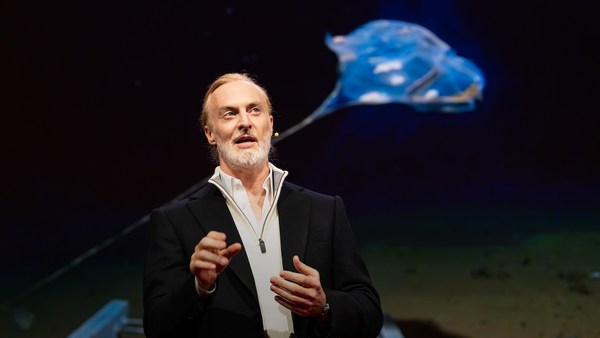
But all of these are mostly invisible to us. The challenge in studying those ocean variables at scale is one of energy, the energy that it takes to deploy sensors into the deep ocean. And of course, many solutions have been tried -- from wave-actuated devices to surface drifters to sun-powered electrical drives -- each with their own compromises. Our team breakthrough came from an unlikely source -- the pursuit of the world speed record in a wind-powered land yacht. It took 10 years of research and development to come up with a novel wing concept that only uses three watts of power to control and yet can propel a vehicle all around the globe with seemingly unlimited autonomy. By adapting this wing concept into a marine vehicle, we had the genesis of an ocean drone.
אבל כל התהליכים האלה הם ברובם בלתי נראים לעינינו. האתגר הכרוך בחקר משתני האוקיינוס הללו בקנה מידה רחב קשור בעיקרו באנרגיה, האנרגיה הנדרשת כדי לתפעל חיישנים בעומק האוקיינוס. וכמובן, הרבה פתרונות נוסו -- החל ממתקנים המופעלים ע"י גלים דרך מתקנים הצפים על פני הים וכלה בהנעה חשמלית ע"י השמש -- כל אחד עם הפשרות שלו. פריצת הדרך של הצוות שלנו הגיעה ממקור לא צפוי -- המרדף אחר שיא מהירות עולמי עבור יאכטת יבשה המונעת ע״י רוח. נדרשו 10 שנות מחקר ופיתוח כדי להגיע לעיצוב כנף חדשני אשר עושה שימוש ב-3 וואט בלבד של הֶספֵּק לצורך בקרה ועדיין יכול להניע כלי תחבורה סביב העולם עם מה שנראה כמו אוטונומיה בלתי מוגבלת. על ידי אימוץ עיצוב הכנף הזה עבור כלי תחבורה ימי, יצרנו לראשונה את ״רחפן-הים״.
Now, these are larger than they appear. They are about 15 feet high, 23 feet long, seven feet deep. Think of them as surface satellites. They're laden with an array of science-grade sensors that measure all key variables, both oceanographic and atmospheric, and a live satellite link transmits this high-resolution data back to shore in real time. Our team has been hard at work over the past few years, conducting missions in some of the toughest ocean conditions on the planet, from the Arctic to the tropical Pacific. We have sailed all the way to the polar ice shelf. We have sailed into Atlantic hurricanes. We have rounded Cape Horn, and we have slalomed between the oil rigs of the Gulf of Mexico. This is one tough robot.
ובכן, הם גדולים יותר ממה שהם נראים. הם בגובה של כ-4.5 מטר, אורך של כ-7 מ', ועומק של כ-2 מ'. חשבו עליהם כעל לוויינים שעל פני השטח. הם מועמסים במערך של חיישנים באיכות מדעית אשר מודדים את כל משתני המפתח, גם האוקיינוגרפיים וגם האטמוספריים, ותקשורת לוויינית חיה משדרת נתונים מדוייקים אלה, בחזרה לחוף בזמן אמת. הצוות שלנו עבד קשה במשך השנים האחרונות, וביצע משימות בתנאי סביבה ימית, מן הקשים שעל כדור הארץ, מן האזור הארקטי של האוקיינוס השקט ועד אזורו הטרופי. הפלגנו כל הדרך אל מדף הקרח הקוטבי. הפלגנו אל תוך הוריקנים אטלנטיים. היקפנו את כף הורן, וזגזגנו בין אסדות הנפט של מפרץ מכסיקו. זהו רובוט ממש קשוח.
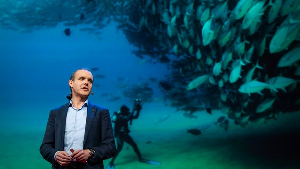
Let me share with you recent work that we did around the Pribilof Islands. This is a small group of islands deep in the cold Bering Sea between the US and Russia. Now, the Bering Sea is the home of the walleye pollock, which is a whitefish you might not recognize, but you might likely have tasted if you enjoy fish sticks or surimi. Yes, surimi looks like crabmeat, but it's actually pollock. And the pollock fishery is the largest fishery in the nation, both in terms of value and volume -- about 3.1 billion pounds of fish caught every year.
הרשו לי לשתף אתכם בעבודה שעשינו לאחרונה סביב איי פריבילוף. זוהי קבוצה קטנה של איים בעומקו של ים בֵּרינג הקר בין ארה"ב לרוסיה. ים ברינג הינו סביבת המגורים של דג הבקלה האלסקית, שזהו דג לבן שאולי אינכם מזהים, אבל קרוב לודאי שטעמתם אותו אם אתם אוהבים מקלות דג או סוּרימי. נכון, סורימי נראה כמו בשר סרטנים, אבל זהו למעשה דג ממשפחת השיבוטיים. ומדגת הדגים השיבוטיים היא המדגה הגדולה ביותר במדינה, גם מבחינת ערך וגם מבחינת כמות -- בערך 1.4 מיליון טון של דגים נתפסים כל שנה.
So over the past few years, a fleet of ocean drones has been hard at work in the Bering Sea with the goal to help assess the size of the pollock fish stock. This helps improve the quota system that's used to manage the fishery and help prevent a collapse of the fish stock and protects this fragile ecosystem. Now, the drones survey the fishing ground using acoustics, i.e., a sonar. This sends a sound wave downwards, and then the reflection, the echo from the sound wave from the seabed or schools of fish, gives us an idea of what's happening below the surface. Our ocean drones are actually pretty good at this repetitive task, so they have been gridding the Bering Sea day in, day out.
וכך במשך מספר השנים האחרונות, צי של רחפנים ימיים עבד קשה בים ברינג במטרה לאמוד את גודלו של מלאי הדגים השיבוטיים. זה מסייע בשיפור מערכת המכסה שמשמשת לנהול המדגה ועוזר במניעת קריסת מלאי הדגים ומגן על מערכת אקולוגית שבירה זו. רחפני-הים סורקים את אזורי גידול הדגה באמצעות אקוסטיקה, כלומר, באמצעות סונאר. הם שולחים גלי קול כלפי מטה, ואז ההד של גלי הקול, המוחזר מקרקעית הים או מלהקות הדגים, נותן לנו מושג מה קורה מתחת לפני הים. רחפני-הים שלנו הם למעשה די טובים במשימות חוזרות ונשנות מעין אלו, וכך הם רישתו את ים ברינג יום אחר יום.
Now, the Pribilof Islands are also the home of a large colony of fur seals. In the 1950s, there were about two million individuals in that colony. Sadly, these days, the population has rapidly declined. There's less than 50 percent of that number left, and the population continues to fall rapidly. So to understand why, our science partner at the National Marine Mammal Laboratory has fitted a GPS tag on some of the mother seals, glued to their furs. And this tag measures location and depth and also has a really cool little camera that's triggered by sudden acceleration. Here is a movie taken by an artistically inclined seal, giving us unprecedented insight into an underwater hunt deep in the Arctic, and the shot of this pollock prey just seconds before it gets devoured.
איי פריבילוף הם גם סביבת המגורים של מושבה גדולה של דובי ים. בשנות ה-50 של המאה העשרים המושבה מנתה כשני מיליון דובים. לצערנו, בימים אלה, האוכלוסיה קָטנה במהירות. פחות מ-50 אחוז ממספר זה נותרו, והאוכלוסיה ממשיכה לקטון במהירות. כדי להבין מדוע, השותף המדעי שלנו במעבדה הלאומית ליונקים ימיים התאים תגית GPS לכמה מהאמהות במושבה, והדביק אותה לפרוותן. והתגית הזאת מודדת מיקום ועומק ויש בה גם מצלמה קטנה ומדליקה המופעלת ע"י האצה פתאומית. הנה סרט שצולם על-ידי דובת ים בעלת נטייה אמנותית, שנותן לנו תובנה חסרת-תקדים על צייד תת-מיימי עמוק בים הארקטי, וצילום של דגי שיבוט אלה שניות לפני שהם נטרפים.
Now, doing work in the Arctic is very tough, even for a robot. They had to survive a snowstorm in August and interferences from bystanders -- that little spotted seal enjoying a ride.
ובכן, העבודה בים הארקטי זו משימה קשה מאד, אפילו עבור רובוט. הם צריכים לשרוד סופת שלגים באוגוסט והפרעות מעוברי אורח -- כלב ים מנוקד קטן זה נהנה לתפוס טרמפ.
(Laughter)
(צחוק)
Now, the seal tags have recorded over 200,000 dives over the season, and upon a closer look, we get to see the individual seal tracks and the repetitive dives. We are on our way to decode what is really happening over that foraging ground, and it's quite beautiful. Once you superimpose the acoustic data collected by the drones, a picture starts to emerge. As the seals leave the islands and swim from left to right, they are observed to dive at a relatively shallow depth of about 20 meters, which the drone identifies is populated by small young pollock with low calorific content. The seals then swim much greater distance and start to dive deeper to a place where the drone identifies larger, more adult pollock, which are more nutritious as fish. Unfortunately, the calories expended by the mother seals to swim this extra distance don't leave them with enough energy to lactate their pups back on the island, leading to the population decline. Further, the drones identify that the water temperature around the island has significantly warmed. It might be one of the driving forces that's pushing the pollock north, and to spread in search of colder regions. So the data analysis is ongoing, but already we can see that some of the pieces of the puzzle from the fur seal mystery are coming into focus.
ובכן, התגיות שעל דובות הים רשמו מעל ל-200,000 צלילות בעונה, ובמבט קרוב יותר, אנו יכולים לראות מסלולים אינדובידואלים ואת הצלילות החוזרות ונשנות. אנחנו בדרכנו לפענח מה שבאמת קורה בשדה הצייד הזה, וזה יפהפה. ברגע שמוסיפים לזה את הנתונים האקוסטיים שנאספו ע"י רחפני-הים התמונה מתחילה להתגלות כאשר דובי הים עוזבים את האיים ושוחים משמאל לימין, נראה שהם צוללים לעומק רדוד יחסית של 20 מטר בערך, אזור שעל פי רחפן-הים מאוכלס בדגי שיבוט קטנים וצעירים בעלי ערך קלורי נמוך. דובי הים שוחים אז למרחק רב יותר ומתחילים לצלול יותר לעומק, לאזור שעל פי רחפן-הים מאוכלס בדגי שיבוט בוגרים וגדולים יותר, ומזינים יותר. לרוע המזל, דובות הים משתמשות בקלוריות העודפות כדי לשחות את המרחק העודף ולא נשארת להן מספיק אנרגיה לייצור חלב עבור הגורים שלהם עם חזרתן לאי, מה שמוביל לדעיכת האוכלוסיה. נוסף על כך, רחפני-הים מזהים שטמפרטורת המים סביב האי עלתה באופן משמעותי. זה עלול להיות אחד הגורמים שמניעים את דגי השיבוט צפונה, וגורמים להם להתפזר בחיפוש אחר אזורים קרים יותר. ניתוח הנתונים עדיין נמשך, אבל אנחנו כבר יכולים לראות שחלקים מחידת חייהם המסתוריים של דובי הים מתחילים להחשף.
But if you look back at the big picture, we are mammals, too. And actually, the oceans provide up to 20 kilos of fish per human per year. As we deplete our fish stocks, what can we humans learn from the fur seal story? And beyond fish, the oceans affect all of us daily as they drive global weather systems, which affect things like global agricultural output or can lead to devastating destruction of lives and property through hurricanes, extreme heat and floods. Our oceans are pretty much unexplored and undersampled, and today, we still know more about other planets than our own.
אבל אם מסתכלים בחזרה על התמונה הגדולה, גם אנחנו יונקים. ולמעשה, האוקיינוסים מספקים לנו עד 20 ק״ג של דגים לכל אדם בשנה. בעוד אנו מדללים את מאגרי הדגים שלנו, מה אנו בני האדם יכולים ללמוד מהסיפור של דובי הים? ומעבר לדגים, האוקיינוסים משפיעים על כולנו מדי יום כיוון שהם מניעים מערכות מזג אויר עולמיות, שמשפיעות על דברים כמו התפוקה החקלאית העולמית או יכולות לגרום לאובדן של חיים ורכוש דרך הוריקנים, חום קיצוני ושטפונות. האוקיינוסים שלנו ברובם טרם נחקרו וטרם נדגמו, והיום, הידע שלנו על כוכבי לכת אחרים קטן מהידע על הכוכב שלנו.
But if you divide this vast ocean in six-by-six-degree squares, each about 400 miles long, you'd get about 1,000 such squares. So little by little, working with our partners, we are deploying one ocean drone in each of those boxes, the hope being that achieving planetary coverage will give us better insights into those planetary systems that affect humanity.
אבל אם תחלקו את האוקיינוסים הענקים האלו למשבצות של שש-על-שש מעלות, כל אחת באורך של כ-640 ק"מ, תקבלו כ-1,000 משבצות כאלה. אז צעד אחר צעד, כשאנו עובדים עם שותפינו, אנו מכניסים לפעולה רחפן-ים בכל אחת ממשבצות אלה, בתקווה שהשגת כיסוי מלא של כדור הארץ תיתן לנו תובנות טובות יותר על המערכות הפלנטריות אשר משפיעות על האנושות.
We have been using robots to study distant worlds in our solar system for a while now. Now it is time to quantify our own planet, because we cannot fix what we cannot measure, and we cannot prepare for what we don't know.
השתמשנו ברובוטים כדי לחקור עולמות רחוקים במערכת השמש שלנו כבר מזה זמן רב. כעת הזמן לכמת את הכוכב שלנו, כי אנו לא יכולים לתקן את מה שאיננו יכולים למדוד, ואנו לא יכולים להתכונן לבלתי ידוע.
Thank you.
תודה רבה.
(Applause)
(מחיאות כפיים)