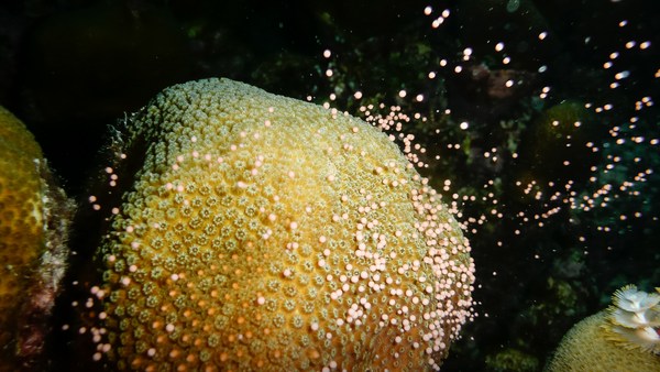
Well, I'm an ocean chemist. I look at the chemistry of the ocean today. I look at the chemistry of the ocean in the past. The way I look back in the past is by using the fossilized remains of deepwater corals. You can see an image of one of these corals behind me. It was collected from close to Antarctica, thousands of meters below the sea, so, very different than the kinds of corals you may have been lucky enough to see if you've had a tropical holiday.
저는 해양 화학자입니다. 오늘날의 해양 화학에 대해 연구하고, 과거의 해양 화학에 대해서도 연구하죠. 과거의 모습은 심해 산호의 화석화된 잔유물을 통해 알 수 있습니다. 제 뒤에 보이는 사진이 그런 산호들인데요. 이건 남극 주변의 수천 미터 깊이의 해저에서 얻은 것입니다. 열대 지방으로 여름휴가를 갔을 때 운이 좋으면 볼 수 있는 산호와는 다른 종류이죠.
So I'm hoping that this talk will give you a four-dimensional view of the ocean. Two dimensions, such as this beautiful two-dimensional image of the sea surface temperature. This was taken using satellite, so it's got tremendous spatial resolution. The overall features are extremely easy to understand. The equatorial regions are warm because there's more sunlight. The polar regions are cold because there's less sunlight. And that allows big icecaps to build up on Antarctica and up in the Northern Hemisphere. If you plunge deep into the sea, or even put your toes in the sea, you know it gets colder as you go down, and that's mostly because the deep waters that fill the abyss of the ocean come from the cold polar regions where the waters are dense.
오늘 제 강연을 통해 바다의 4차원적 모습에 대해 알 수 있게 되기를 바랍니다. 2차원적 모습은 이런 해수면 온도 사진을 예로 들 수 있습니다. 위성 사진이기에 엄청나게 큰 공간 해상도를 갖습니다. 전반적인 특징들도 무척 이해하기 쉽죠. 적도 주변은 햇빛을 많이 받아서 더 따뜻합니다. 극지방은 햇빛이 적기에 더 차갑죠. 그 결과로 남극과 북반구 윗쪽에 커다란 만년빙이 만들어집니다. 바다 속으로 들어가면, 심지어 발만 담그더라도 아래로 내려갈수록 차가워짐을 알 수 있습니다. 그 주된 이유는 해저의 심층수는 추운 극지방에서 온 밀도가 높은 물로 이루어져 있기 때문입니다.
If we travel back in time 20,000 years ago, the earth looked very much different. And I've just given you a cartoon version of one of the major differences you would have seen if you went back that long. The icecaps were much bigger. They covered lots of the continent, and they extended out over the ocean. Sea level was 120 meters lower. Carbon dioxide [levels] were very much lower than they are today. So the earth was probably about three to five degrees colder overall, and much, much colder in the polar regions.
2만년 전으로 거슬러 올라가면, 지구는 지금과 전혀 다른 모습이었습니다. 그 당시로 돌아갔을 때 볼 수 있는 가장 큰 차이를 조금 전에 만화로 보여드렸는데요. 만년빙은 훨씬 더 컸습니다. 여러 대륙을 뒤덮었고, 바다까지 뻗어있었죠. 해수면은 지금보다 120미터 더 낮았습니다. 이산화탄소 농도는 현재보다 훨씬 더 낮은 수준이었죠. 그래서 지구는 전체적으로 현재보다 3에서 5도 가량 더 낮았을 겁니다. 그리고 극지방은 훨씬 더 추웠을 거예요.
What I'm trying to understand, and what other colleagues of mine are trying to understand, is how we moved from that cold climate condition to the warm climate condition that we enjoy today. We know from ice core research that the transition from these cold conditions to warm conditions wasn't smooth, as you might predict from the slow increase in solar radiation. And we know this from ice cores, because if you drill down into ice, you find annual bands of ice, and you can see this in the iceberg. You can see those blue-white layers. Gases are trapped in the ice cores, so we can measure CO2 -- that's why we know CO2 was lower in the past -- and the chemistry of the ice also tells us about temperature in the polar regions. And if you move in time from 20,000 years ago to the modern day, you see that temperature increased. It didn't increase smoothly. Sometimes it increased very rapidly, then there was a plateau, then it increased rapidly. It was different in the two polar regions, and CO2 also increased in jumps.
저와 제 동료들은 그 차가웠던 기후에서 현재 우리가 즐기는 따뜻한 기후로 어떻게 변화했는지 알아내려고 했습니다. 빙핵 조사를 통해 알아낸 사실은 한대 기후에서 온대 기후로 완만히 변화한 것이 아니라는 것입니다. 태양 복사가 서서히 증가한 것에서 예측할 수 있는 사실과는 다르죠. 이런 사실은 빙핵을 통해 알 수 있습니다. 얼음을 파들어가면 빙하에서 얼음 나이테를 볼 수 있어요. 이렇게 푸르고 흰 층으로 나타납니다. 빙핵 안에 갇혀있는 기체에서 이산화탄소 농도를 측정해서 과거에는 이산화탄소 농도가 더 낮았다는 걸 알아냈고, 얼음의 화학적 성질로부터 극지방의 온도에 대해서도 알 수 있었습니다. 그리고 2만년 전부터 현재에 이르는 동안에 온도가 올랐다는 걸 확인할 수 있었죠. 부드럽게 증가한 건 아닙니다. 가끔 급격하게 올랐다가 일정하게 유지되었다가 다시 급격히 증가했습니다. 두 극지방에서 다르게 나타났고, 이산화탄소 농도도 그렇게 증가했습니다.
So we're pretty sure the ocean has a lot to do with this. The ocean stores huge amounts of carbon, about 60 times more than is in the atmosphere. It also acts to transport heat across the equator, and the ocean is full of nutrients and it controls primary productivity.
저희는 이런 변화가 바다와 관련있다고 확신합니다. 해양에는 대기의 60여 배에 달하는 양의 이산화탄소가 녹아 있습니다. 바다는 적도의 열을 운반하기도 하고, 풍부한 영양분을 공급하고, 식물 플랑크톤을 관리하죠.
So if we want to find out what's going on down in the deep sea, we really need to get down there, see what's there and start to explore. This is some spectacular footage coming from a seamount about a kilometer deep in international waters in the equatorial Atlantic, far from land. You're amongst the first people to see this bit of the seafloor, along with my research team. You're probably seeing new species. We don't know. You'd have to collect the samples and do some very intense taxonomy. You can see beautiful bubblegum corals. There are brittle stars growing on these corals. Those are things that look like tentacles coming out of corals. There are corals made of different forms of calcium carbonate growing off the basalt of this massive undersea mountain, and the dark sort of stuff, those are fossilized corals, and we're going to talk a little more about those as we travel back in time.
그래서 심해에서 벌어지는 일들에 대해 알고자 한다면, 그곳으로 내려가 어떤 것이 있는지를 보고 탐험해야만 합니다. 이 놀라운 영상은 대륙에서 멀리 떨어진 적도 대서양의 수심 1km에 위치한 해저산을 찍은 것입니다. 여러분들께서는 저희 연구팀과 더불어 이 영상을 최초로 보셨습니다. 새로운 생물들도 보이실 겁니다. 저희도 아직 모릅니다. 일부 시료를 채취해서 상세 분류를 해야 할 겁니다. 아름다운 풍선껌 산호도 볼 수 있습니다. 산호 주변에는 거미불가사리가 붙어서 자라기도 하는데요. 마치 산호 밖으로 나온 촉수처럼 보입니다. 거대한 해저산맥의 현무암에서 만들어진 다른 형태의 탄산 칼슘으로 이루어진 산호들도 있습니다. 그리고 약간 어두운 것들은 화석화된 산호들인데요, 바다의 과거에 대한 이야기를 할 때 좀 더 자세히 말씀드리겠습니다.
To do that, we need to charter a research boat. This is the James Cook, an ocean-class research vessel moored up in Tenerife. Looks beautiful, right? Great, if you're not a great mariner. Sometimes it looks a little more like this. This is us trying to make sure that we don't lose precious samples. Everyone's scurrying around, and I get terribly seasick, so it's not always a lot of fun, but overall it is.
그러기 위해서는 연구선을 띄워야 합니다. 이 배는 테너리프에 정박중인 해양 연구선 제임스 쿡 호입니다. 멋지지 않나요? 대단하죠. 뛰어난 뱃사람이 아니라면 가끔은 이런 상황도 벌어집니다. 소중한 시료들을 잃지 않기 위해 노력하는 모습입니다. 죄다 여기저기 날려다니고, 저는 배멀미가 심하게 났었어요. 항상 재미있는 건 아니지만, 대체로는 그렇습니다.
So we've got to become a really good mapper to do this. You don't see that kind of spectacular coral abundance everywhere. It is global and it is deep, but we need to really find the right places. We just saw a global map, and overlaid was our cruise passage from last year. This was a seven-week cruise, and this is us, having made our own maps of about 75,000 square kilometers of the seafloor in seven weeks, but that's only a tiny fraction of the seafloor. We're traveling from west to east, over part of the ocean that would look featureless on a big-scale map, but actually some of these mountains are as big as Everest. So with the maps that we make on board, we get about 100-meter resolution, enough to pick out areas to deploy our equipment, but not enough to see very much. To do that, we need to fly remotely-operated vehicles about five meters off the seafloor. And if we do that, we can get maps that are one-meter resolution down thousands of meters. Here is a remotely-operated vehicle, a research-grade vehicle. You can see an array of big lights on the top. There are high-definition cameras, manipulator arms, and lots of little boxes and things to put your samples.
이 일을 위해 저희는 뛰어난 지도제작자가 되어야 합니다. 그렇게 웅장한 산호초를 어디서나 볼 수 있는 건 아니거든요. 아주 광대하고, 깊이 있습니다. 그렇기에 정확한 장소를 찾아야 하죠. 작년에 저희가 지나간 길을 세계지도에 그려봤습니다. 7주간의 항해였는데요, 그 기간 동안 작성한 해저지도 면적은 75,000 평방 km에 달하지만 전체 해저의 극히 일부에 불과합니다. 서에서 동으로 이동하는 동안, 큰 지도로 보면 별 것 아닌 지역을 지나기도 했지만, 몇몇 해저 산맥은 에베레스트만큼 높았습니다. 배 위에서 100 m의 해상도로 지도를 만들었는데요. 장비 설치를 위한 장소를 물색하는 데에는 적합했지만 많은 걸 보기엔 부족했었습니다. 저 자세히 보기 위해서는 해저에서 5 m 정도 떨어진 곳까지 무선 조종 탐사선을 띄워야만 했습니다. 그렇게만 한다면 해저 수천 m까지도 1 m 해상도의 지도를 그릴 수 있습니다. 이게 바로 무선조종이 가능한 연구용 탐사선입니다. 위쪽에 조명이 많이 달려 있죠. 고화질의 영상 장비와 로봇팔, 그리고 시료를 담을 수 있는 여러 개의 상자가 있습니다.
Here we are on our first dive of this particular cruise, plunging down into the ocean. We go pretty fast to make sure the remotely operated vehicles are not affected by any other ships. And we go down, and these are the kinds of things you see. These are deep sea sponges, meter scale. This is a swimming holothurian -- it's a small sea slug, basically. This is slowed down. Most of the footage I'm showing you is speeded up, because all of this takes a lot of time. This is a beautiful holothurian as well. And this animal you're going to see coming up was a big surprise. I've never seen anything like this and it took us all a bit surprised. This was after about 15 hours of work and we were all a bit trigger-happy, and suddenly this giant sea monster started rolling past. It's called a pyrosome or colonial tunicate, if you like. This wasn't what we were looking for. We were looking for corals, deep sea corals. You're going to see a picture of one in a moment. It's small, about five centimeters high. It's made of calcium carbonate, so you can see its tentacles there, moving in the ocean currents. An organism like this probably lives for about a hundred years. And as it grows, it takes in chemicals from the ocean. And the chemicals, or the amount of chemicals, depends on the temperature; it depends on the pH, it depends on the nutrients. And if we can understand how these chemicals get into the skeleton, we can then go back, collect fossil specimens, and reconstruct what the ocean used to look like in the past. And here you can see us collecting that coral with a vacuum system, and we put it into a sampling container. We can do this very carefully, I should add.
보시는 것은 이번 항해에서 첫 번째 탐사가 이뤄지는 순간인데요. 무선 탐사선이 다른 선박의 영향을 받지 않도록 하기 위해 아주 빠른 속도로 해저로 내려갑니다. 이렇게 내려가게 되면 다음과 같은 광경들이 펼쳐집니다. 미터 크기의 심해 해면 동물입니다. 떠다니고 있는 해삼인데요. 말하자면, 바다의 민달팽이입니다. 느린 영상입니다. 여러분께 보여드릴 대부분의 영상은 빨리 감은 영상들입니다. 촬영 시간이 무척 길거든요. 여기 아름다운 해삼이 하나 더 있네요. 이번에 보실 생물은 아주 놀라운 녀석입니다. 저희도 본 적이 없는 녀석이라 다들 적잖이 놀랐습니다. 탐사가 15시간이나 이어진 뒤라 다들 신경이 조금 곤두선 상태였는데 이 거대한 바다 괴물이 갑자기 지나가기 시작했죠. 이건 불우렁쉥이 혹은 판멍게라고 불립니다. 저희가 찾고 있던 건 아니었죠. 저희는 심해 산호를 찾고 있었습니다. 잠시 뒤에 보여드릴 건데요. 아주 작아요. 높이도 5 cm 정도이죠. 탄산 칼슘으로 이루어졌는데, 촉수가 해류에 따라 움직이는 게 보이실 겁니다. 이런 생물들은 거의 100년을 살 수 있습니다. 그리고 자라면서 바다의 화학 물질을 흡수하죠. 화학 물질의 종류와 양은 온도와 pH값에 따라 다르고, 영양분에 따라서도 달라집니다. 이러한 화학 물질들이 산호의 골격을 형성하게 된 과정을 안다면 화석 시료를 채취해서 과거 모습이 어떠했는지 알아낼 수 있습니다. 이 영상은 진공 장치로 산호를 수집해서 시료 상자에 넣는 모습입니다. 아주 조심스러운 작업이란 걸 꼭 말해두고 싶네요.
Some of these organisms live even longer. This is a black coral called Leiopathes, an image taken by my colleague, Brendan Roark, about 500 meters below Hawaii. Four thousand years is a long time. If you take a branch from one of these corals and polish it up, this is about 100 microns across. And Brendan took some analyses across this coral -- you can see the marks -- and he's been able to show that these are actual annual bands, so even at 500 meters deep in the ocean, corals can record seasonal changes, which is pretty spectacular.
어떤 생물들은 훨씬 더 오래 살기도 합니다. 이건 하와이 해저 500 m에서 제 동료인 브랜든 로아크가 찍은 검은 산호(Leiopathes)의 사진입니다. 4000년은 아주 긴 시간입니다. 가지를 하나 얻어서 다듬으면 폭이 100 마이크론 정도됩니다. 브랜든이 이 산호를 분석했는데요, 보시다시피 자국이 남아있었죠. 그가 알아낸 사실은 해저 500 m에서도 나이테를 확인할 수 있고, 기후의 변화가 산호에 기록된다는 것이죠. 굉장히 멋지지 않나요?
But 4,000 years is not enough to get us back to our last glacial maximum. So what do we do? We go in for these fossil specimens. This is what makes me really unpopular with my research team. So going along, there's giant sharks everywhere, there are pyrosomes, there are swimming holothurians, there's giant sponges, but I make everyone go down to these dead fossil areas and spend ages kind of shoveling around on the seafloor. And we pick up all these corals, bring them back, we sort them out. But each one of these is a different age, and if we can find out how old they are and then we can measure those chemical signals, this helps us to find out what's been going on in the ocean in the past.
하지만 마지막 최대빙하기까지 가기에는 4000년으로는 부족합니다. 어떻게 해야 할까요? 저희는 이 화석 시료를 이용하기로 했습니다. 덕분에 저는 저희 연구팀에서 별로 인기없는 사람이 되었는데요. 다니기만 해도 거대한 상어와 불우렁쉥이, 해삼, 그리고 큰 해면동물들이 가득하지만, 저는 모든 연구원들이 죽은 화석이 가득한 곳에서 끊임없이 바닥을 쓸어담게 했거든요. 이 산호화석들을 가져와서 분류하는거죠. 하지만 모두 연령대가 달랐기에 나이와 화학적 지표를 측정할 수만 있다면 과거의 해양에 무슨 일이 있었는지 알 수 있습니다.
So on the left-hand image here, I've taken a slice through a coral, polished it very carefully and taken an optical image. On the right-hand side, we've taken that same piece of coral, put it in a nuclear reactor, induced fission, and every time there's some decay, you can see that marked out in the coral, so we can see the uranium distribution. Why are we doing this? Uranium is a very poorly regarded element, but I love it. The decay helps us find out about the rates and dates of what's going on in the ocean. And if you remember from the beginning, that's what we want to get at when we're thinking about climate. So we use a laser to analyze uranium and one of its daughter products, thorium, in these corals, and that tells us exactly how old the fossils are.
왼쪽 사진은 제가 산호의 일부를 떼서 조심스레 닦아낸 후 광학 사진을 찍은 것입니다. 오른쪽 사진에서는 동일한 산호 조각을 원자로에 넣어서 유도 핵분열을 통해 핵붕괴가 일어날 때마다 산호에 흔적이 남게 되고 이를 통해 우라늄의 분포를 확인할 수 있습니다. 왜 이런 작업을 거칠까요? 우라늄은 별로 대접받지 못하는 원소지만 저는 아주 좋아합니다. 핵붕괴는 해양의 변화 정도나 시기를 알아내는 데에 도움을 주죠. 처음에 말씀드린 것과 같이, 기후와 관련하여 저희가 알고자 하는 것이 바로 그것입니다. 그래서 저희는 레이저를 이용해서 산호 안의 우라늄과 핵붕괴 부산물 중 하나인 토륨을 분석하였고, 이를 통해 화석의 정확한 연대를 알 수 있습니다.
This beautiful animation of the Southern Ocean I'm just going to use illustrate how we're using these corals to get at some of the ancient ocean feedbacks. You can see the density of the surface water in this animation by Ryan Abernathey. It's just one year of data, but you can see how dynamic the Southern Ocean is. The intense mixing, particularly the Drake Passage, which is shown by the box, is really one of the strongest currents in the world coming through here, flowing from west to east. It's very turbulently mixed, because it's moving over those great big undersea mountains, and this allows CO2 and heat to exchange with the atmosphere in and out. And essentially, the oceans are breathing through the Southern Ocean. We've collected corals from back and forth across this Antarctic passage, and we've found quite a surprising thing from my uranium dating: the corals migrated from south to north during this transition from the glacial to the interglacial. We don't really know why, but we think it's something to do with the food source and maybe the oxygen in the water.
지금 보시는 이 아름다운 영상은 남극해입니다. 저희가 고대 해양의 정보를 얻기 위해 산호를 어떻게 이용했는지를 설명해 드리려고 하는데요. 라이언 아버나시가 만든 이 영상에서 표층수의 밀도를 볼 수 있습니다. 비록 1년 밖에 안 되는 자료지만, 남극해가 굉장히 역동적이라는 걸 알 수 있습니다. 특히 상자표시 안의 드레이크 해협에서 맹렬한 뒤섞임이 나타나는데요. 이는 세계에서 가장 강력한 해류 중의 하나로서 서에서 동으로 흐릅니다. 해류가 거대한 해저 산맥을 지나가기 때문에 심하게 소용돌이 치며 뒤섞이고, 덕분에 이산화탄소와 열이 대기와 교환될 수 있습니다. 본질적으로 바다는 남극해를 통해 숨쉬고 있는 거죠. 저희는 남극 해협 이곳저곳에서 산호를 모았고, 우라늄 연대 측정을 통해 꽤 놀라운 사실을 발견했습니다. 빙하기에서 간빙기로 바뀌는 동안 산호가 남에서 북으로 이동했다는 사실입니다. 정확한 이유는 알 수 없지만, 먹이나 수중 용존산소와 관련이 있을 것으로 생각합니다.
So here we are. I'm going to illustrate what I think we've found about climate from those corals in the Southern Ocean. We went up and down sea mountains. We collected little fossil corals. This is my illustration of that. We think back in the glacial, from the analysis we've made in the corals, that the deep part of the Southern Ocean was very rich in carbon, and there was a low-density layer sitting on top. That stops carbon dioxide coming out of the ocean. We then found corals that are of an intermediate age, and they show us that the ocean mixed partway through that climate transition. That allows carbon to come out of the deep ocean. And then if we analyze corals closer to the modern day, or indeed if we go down there today anyway and measure the chemistry of the corals, we see that we move to a position where carbon can exchange in and out. So this is the way we can use fossil corals to help us learn about the environment.
자 이제, 남극해의 산호를 통해 기후에 대해 알게 된 사실을 보여드리려고 합니다. 해저 산맥을 오르내리면서 작은 화석 산호를 모았습니다. 이건 저만의 방식으로 표현한 것이에요. 산호에서 얻은 분석을 통해 저희는 과거 빙하기에는 남극해의 깊은 부분은 탄소가 굉장히 많았고, 저밀도의 층이 그 위에 있었다고 생각합니다. 이것이 이산화탄소가 바다 밖으로 나오는 걸 방지했죠. 그리고 저희는 중간 시기의 산호를 찾았는데요. 이를 통해 기후가 변하면서 바다의 뒤섞임도 있었음을 알 수 있었습니다. 덕분에 심해로부터 탄소가 나올 수 있었죠. 그래서 최근 시기의 산호를 조사하거나, 오늘이라도 해저로 내려가서 산호의 화학 성분을 측정한다면, 탄소가 안팎으로 드나들 수 있는 상태로 변천되었음을 볼 수 있습니다. 이것이 환경에 대해 알기 위해 화석화된 산호를 사용하는 방법입니다.
So I want to leave you with this last slide. It's just a still taken out of that first piece of footage that I showed you. This is a spectacular coral garden. We didn't even expect to find things this beautiful. It's thousands of meters deep. There are new species. It's just a beautiful place. There are fossils in amongst, and now I've trained you to appreciate the fossil corals that are down there.
이 슬라이드를 마지막으로 이만 마치려고 합니다. 제가 처음에 보여드린 영상의 일부입니다. 굉장히 멋진 산호 정원이죠. 이렇게 아름다운 걸 발견하리라곤 저희도 생각 못했습니다. 수천m 깊이의 해저에서 말이죠. 새로운 생물도 있습니다. 아주 멋진 곳이에요. 그 가운데에 산호 화석이 있죠. 제가 여러분께 바다 속 산호 화석들을 아껴달라고 말씀드렸습니다.
So next time you're lucky enough to fly over the ocean or sail over the ocean, just think -- there are massive sea mountains down there that nobody's ever seen before, and there are beautiful corals.
행여나 다음에 바다 위를 비행하거나 배를 타고 지나가실 때, 그 아래에 누구도 보지 못한 거대한 해저 산맥과 아름다운 산호들이 있다는 걸 생각해주시길 바랍니다.
Thank you.
감사합니다.
(Applause)
(박수)