Well, I'm an ocean chemist. I look at the chemistry of the ocean today. I look at the chemistry of the ocean in the past. The way I look back in the past is by using the fossilized remains of deepwater corals. You can see an image of one of these corals behind me. It was collected from close to Antarctica, thousands of meters below the sea, so, very different than the kinds of corals you may have been lucky enough to see if you've had a tropical holiday.
خب من کیمیاگر اقیانوس هستم. شیمی کنونی اقیانوس را بررسی میکنم. به شیمی توی اقیانوسها در گذشته نگاه میکنم. طرز نگاهم به گذشته با استفاده از بقایای فسیل شده مرجانهای اعماق دریاست. تصویری که پشت سرم میببینین یکی از این مرجانهاست. از نزدیکیهای جنوبگان،هزاران متر زیر دریا جمعآوری شده، پس خیلی متفاوت از مرجانهایی است که در صورت رفتن به سفر استوایی احتمالا شانس دیدنش را داشتهاید.
So I'm hoping that this talk will give you a four-dimensional view of the ocean. Two dimensions, such as this beautiful two-dimensional image of the sea surface temperature. This was taken using satellite, so it's got tremendous spatial resolution. The overall features are extremely easy to understand. The equatorial regions are warm because there's more sunlight. The polar regions are cold because there's less sunlight. And that allows big icecaps to build up on Antarctica and up in the Northern Hemisphere. If you plunge deep into the sea, or even put your toes in the sea, you know it gets colder as you go down, and that's mostly because the deep waters that fill the abyss of the ocean come from the cold polar regions where the waters are dense.
بنابراین امیدورم که این سخنرانی به شما دیدگاهی چهار بعدی از اقیانوس را بدهد. دو بعد، مثل این تصویر دو بعدی زیبا از دمای سطح دریا. با استفاده از ماهواره گرفته شده، بنابراین وضوح فضایی فوقالعادهایی دارد. درک ویژگیهای کلی آن بسیار آسان است. مناطق استوایی گرم هستند چون آفتاب بیشتر است. مناطق قطبی سرد هستند چون آفتاب کمتر است. و امکان ساخته شدن کلاهکهای یخی بزرگ در جنوبگان و بالای نیمکره شمالی را میدهد. اگر در ژرفای آب فرو بروید یا حتی انگشتانتان را توی دریا فرو کنید، میدانید که هر چه پایینتر بروید سردتر میشود، و بیشتر بخاطر این است که آبهای عمیقی که قعر اقیانوس را پر میکند از مناطق قطبی سردی هستند که آنجا آبها متراکماند.
If we travel back in time 20,000 years ago, the earth looked very much different. And I've just given you a cartoon version of one of the major differences you would have seen if you went back that long. The icecaps were much bigger. They covered lots of the continent, and they extended out over the ocean. Sea level was 120 meters lower. Carbon dioxide [levels] were very much lower than they are today. So the earth was probably about three to five degrees colder overall, and much, much colder in the polar regions.
اگر به ۲۰٫۰۰۰ سال قبل سفر کنیم، زمین خیلی متفاوت به نظر میرسید. و الان برایتان کارتونی نشان دادم از یکی از تفاوتهای اساسی که اگر به گذشتههای دور برمیگشتید می دیدید. کلاهکهای یخی بزرگتر بودند. بیشتر قاره را پوشانده بودند، و تمام اقیانوس را گرفته بودند. سطح دریا ۱۲۰ متر پایینتر بود. دی اکسیدکربن خیلی کمتر از امروز بود. بنابراین به طورکلی زمین احتمالا حدود سه تا پنج درجه سردتر بود، و در نواحی قطبی خیلی خیلی سردتر.
What I'm trying to understand, and what other colleagues of mine are trying to understand, is how we moved from that cold climate condition to the warm climate condition that we enjoy today. We know from ice core research that the transition from these cold conditions to warm conditions wasn't smooth, as you might predict from the slow increase in solar radiation. And we know this from ice cores, because if you drill down into ice, you find annual bands of ice, and you can see this in the iceberg. You can see those blue-white layers. Gases are trapped in the ice cores, so we can measure CO2 -- that's why we know CO2 was lower in the past -- and the chemistry of the ice also tells us about temperature in the polar regions. And if you move in time from 20,000 years ago to the modern day, you see that temperature increased. It didn't increase smoothly. Sometimes it increased very rapidly, then there was a plateau, then it increased rapidly. It was different in the two polar regions, and CO2 also increased in jumps.
آنچه سعی میکنم بفهمم و سایر همکارانم تلاش در فهم آن دارند، این است که چطور از شرایط آب و هوایی سرد به شرایط آب و هوایی گرمی رسیدیم که امروز از آن لذت میبریم. از تحقیقات هسته یخی دریافتیم که انتقال از این شرایط سرد به شرایط گرم آنطور که شاید از افزایش آهسته تشعشعات خورشیدی انتظار داشته باشید، تدریجی نبود. و این را از هسته های یخی فهمیدیم، چون اگر مته را داخل یخ بفرستید، نوارهای سالیانهای از یخ را میابید و این را در کوههای یخی هم می بینید. آن لایههای سفید- آبی را میبینید. گازها در هسته های یخی به دام افتادهاند، پس میتوان CO2 را اندازه گرفت-- برای همین است که میدانیم CO2 در گذشته کمتر بود-- و شیمی یخ به ما درباره دما در نواحی قطبی میگوید. و اگر با زمان از ۲۰٫۰۰۰ سال قبل به عصر جدید بیایید، میبینید که دما افزلیش یافته. این افزایش آهسته نیست. گاهی این افزایش بسیار سریع بوده، سپس به کفه (حالت پایدار) رسیده، بعد افزایش سریع داشته. در دو ناحیه قطبی متفاوت بوده، و CO2 هم افزایش ناگهانی داشته.
So we're pretty sure the ocean has a lot to do with this. The ocean stores huge amounts of carbon, about 60 times more than is in the atmosphere. It also acts to transport heat across the equator, and the ocean is full of nutrients and it controls primary productivity.
پس کاملا مطمئن هستیم اقیانوس خیلی با این ارتباط دارد. اقیانوس مقدار زیادی کربن ذخیره میکند، حدود ۶۰ برابر بیشتر از مقداری که در جو (اتمسفر) هست. اقیانوس همچنین باعث انتقال گرما از مناطق استوایی می شود، و پر از مواد مغذیاست و (با فتوسنتز و کموسنتز) تولید مواد آلی خام را کنترل میکند.
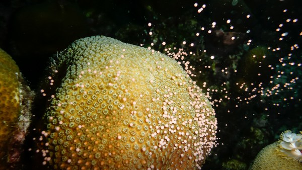
So if we want to find out what's going on down in the deep sea, we really need to get down there, see what's there and start to explore. This is some spectacular footage coming from a seamount about a kilometer deep in international waters in the equatorial Atlantic, far from land. You're amongst the first people to see this bit of the seafloor, along with my research team. You're probably seeing new species. We don't know. You'd have to collect the samples and do some very intense taxonomy. You can see beautiful bubblegum corals. There are brittle stars growing on these corals. Those are things that look like tentacles coming out of corals. There are corals made of different forms of calcium carbonate growing off the basalt of this massive undersea mountain, and the dark sort of stuff, those are fossilized corals, and we're going to talk a little more about those as we travel back in time.
پس اگر بخواهیم بفهمیم در اعماق دریا چه خبر است، واقعا باید برویم آن پایین تا ببینیم آنجا چه هست و شروع به کاوش کنیم. صحنه ی دیدنی از یک صخره دریایی در عمق تقریباً یک کیلومتری در آبهای بین المللی در بخش استوایی اقیانوس اطلس، به دور از خشکی. شما از اولین کسانی هستید که این بخش از بستر دریا را همراه با تیم تحقیق من می بینید. احتمالا گونههای جدیدی را میبینید. نمیدانیم. باید نمونهها را جمعآوری و به دقت طبقه بندی کنید. این مرجانهای آدامس بادکنکی زیبا را میبینید. ستارههای شکنندهای وجود دارد که روی این مرجانها رشد میکند. همان چیزهایی که مثل شاخک از مرجانها بیرون آمده. مرجانهایی از جنس کربنات کلسیم در شکل های مختلف در بستر این صخره های عظیم بازالت در زیر آب، و آن چیزهای تیره، مرجانهای فسیل شده هستند، و درباره اش بیشتر خواهیم گفت در طول سفر به گذشته.
To do that, we need to charter a research boat. This is the James Cook, an ocean-class research vessel moored up in Tenerife. Looks beautiful, right? Great, if you're not a great mariner. Sometimes it looks a little more like this. This is us trying to make sure that we don't lose precious samples. Everyone's scurrying around, and I get terribly seasick, so it's not always a lot of fun, but overall it is.
برای این کار، باید یک قایق تحقیقی کرایه کنیم. این جیمز کوک است، کشتی تحقیقی اقیانوس پیما که در تنریف لنگر انداخته. زیباست، نه؟ عالیه، اگر که دریانورد زبدهای نیستید. گاهی بیشتر مثل این میماند. این ما هستیم که سعی می کنیم این نمونههای گرانبها گم نشود. همه در اطراف شتابزده هستند، و من به شدت دریازده شده ام، خیلی خوش نمی گذرد، اما به طور کلی خوب است.
So we've got to become a really good mapper to do this. You don't see that kind of spectacular coral abundance everywhere. It is global and it is deep, but we need to really find the right places. We just saw a global map, and overlaid was our cruise passage from last year. This was a seven-week cruise, and this is us, having made our own maps of about 75,000 square kilometers of the seafloor in seven weeks, but that's only a tiny fraction of the seafloor. We're traveling from west to east, over part of the ocean that would look featureless on a big-scale map, but actually some of these mountains are as big as Everest. So with the maps that we make on board, we get about 100-meter resolution, enough to pick out areas to deploy our equipment, but not enough to see very much. To do that, we need to fly remotely-operated vehicles about five meters off the seafloor. And if we do that, we can get maps that are one-meter resolution down thousands of meters. Here is a remotely-operated vehicle, a research-grade vehicle. You can see an array of big lights on the top. There are high-definition cameras, manipulator arms, and lots of little boxes and things to put your samples.
خب ما برای این کار باید نقشهبردار واقعا خوبی باشیم. چنان منظره دیدنی از توده عظیم مرجانی را هرجایی نمیبینید. یک دست و عمیق، اما باید دنبال جاهای واقعاً مناسب باشیم. فقط یک نقشه کلی را دیدیم و مسیر دریانوردی ما که مال پارسال بود. ۷ هفته دریانوردی، و این ماهستیم، با نقشههایی که خودمان ساختیم از حدود ۷۵٫۰۰۰ کیلومتر مربع از کف دریا در عرض هفت هفته، اما این تنها کسر کوچکی از سطح دریاست. ما از غرب به شرق سفر میکنیم، بر بخشی از اقیانوس که روی نقشهای با مقیاس بزرگ جلب توجه نمی کند، اما درواقع برخی از این کوهها به بزرگی اورست هستند. با نقشههایی که در عرشه می کشیم، با وضوح حدود ۱۰۰ متر، که برای انتخاب محدوده برای استقرار تجهیزاتمان کافی است، اما آنقدر کافی نیست که خیلی چیزها را ببینیم. برای این کار تجهیزات قابل هدایت از راه دور لازم داریم در عمق تقریباً ۵ متر بالاتر از بستر دریا. و اگر این کار را انجام دهیم، نقشههایی خواهیم داشت با وضوح یک متر تا هزاران متر. این یک وسیله قابل هدایت از راه دور است، یک وسیله تحقیقاتی. آن بالا انواع نورافکن های بزرگ را میبینید. دوربینهای با وضوح بالا، بازوهای مکانیکی، و کلی جعبههای کوچک و چیزهایی برای گذاشتن نمونه هایتان.
Here we are on our first dive of this particular cruise, plunging down into the ocean. We go pretty fast to make sure the remotely operated vehicles are not affected by any other ships. And we go down, and these are the kinds of things you see. These are deep sea sponges, meter scale. This is a swimming holothurian -- it's a small sea slug, basically. This is slowed down. Most of the footage I'm showing you is speeded up, because all of this takes a lot of time. This is a beautiful holothurian as well. And this animal you're going to see coming up was a big surprise. I've never seen anything like this and it took us all a bit surprised. This was after about 15 hours of work and we were all a bit trigger-happy, and suddenly this giant sea monster started rolling past. It's called a pyrosome or colonial tunicate, if you like. This wasn't what we were looking for. We were looking for corals, deep sea corals. You're going to see a picture of one in a moment. It's small, about five centimeters high. It's made of calcium carbonate, so you can see its tentacles there, moving in the ocean currents. An organism like this probably lives for about a hundred years. And as it grows, it takes in chemicals from the ocean. And the chemicals, or the amount of chemicals, depends on the temperature; it depends on the pH, it depends on the nutrients. And if we can understand how these chemicals get into the skeleton, we can then go back, collect fossil specimens, and reconstruct what the ocean used to look like in the past. And here you can see us collecting that coral with a vacuum system, and we put it into a sampling container. We can do this very carefully, I should add.
اینجا ما در اولین غواصی خود در این سفر دریایی خاص هستیم، تا ته اقیانوس میرویم. نسبتا سریع می رویم تا مطمئن شویم که وسایل هدایت پذیر از دور تحتتاثیر دیگر کشتیها قرار نمیگیرد. و پایین میرویم، و این چیزهایی است که میبینید. اینها اسفنجهای ته دریا هستند با مقیاس متر. یک خیار دریایی چرمی شناور-- در واقع یک حلزون دریایی کوچک است. سرعتش کم شده. بیشتر فیلمهایی که نشان میدهم سرعتشان زیاد شده، چون همه اینها خیلی زمان میبرد. یک خیار دریایی چرمی زیبای دیگر. و این حیوانی که خواهید دید واقعاً عجیب بود. هرگز چیزی مثل این را قبلا ندیدهام و کمی باعث شگفتی ما شد. بعد از حدود ۱۵ ساعت کار بود و خوشحال بودیم، و یکهو این هیولای دریایی غولپیکر غلت زنان از جلوی ما گذشت. اسمش آتشتنان یا همان آبدزدک دریایی است. چیزی نبود که دنبالش باشیم. دنبال مرجانها بودیم، مرجانهای عمق دریا. عکس یکی از آنها را به زودی میبینید. کوچک است بارتفاع حدود ۵ سانتیمتر. از کلسیم کربنات ساخته شده، میتوانید شاخکهایش را آنجا ببینید، که با جریانهای اقیانوس حرکت میکند. جانداری مثل این احتمالا حدود ۵۰۰ سال عمر میکند. و همانطور که رشد میکند، مواد شیمیایی را از اقیانوس جذب میکند. و نوع مواد شیمیایی، یا مقدار مواد شیمیایی به دما بستگی دارد؛ به pH و به مواد غذایی بستگی دارد. و اگر بتوانیم بفهمیم چطور این مواد شیمیایی وارد اسکلت شده، میتوانیم برگردیم و نمونههای فسیلی گردآوری کنیم، و وضعیت اقیانوس را در گذشته بازسازی کنیم. و میتوانید ببینید آن مرجان را با یک سیستم خلاء جمعآوری میکنیم، و آن را داخل یک ظرف نمونهگیری قرار میدهیم. باید اضافه کنم که میتوانیم این کار را خیلی با احتیاط انجام دهیم.
Some of these organisms live even longer. This is a black coral called Leiopathes, an image taken by my colleague, Brendan Roark, about 500 meters below Hawaii. Four thousand years is a long time. If you take a branch from one of these corals and polish it up, this is about 100 microns across. And Brendan took some analyses across this coral -- you can see the marks -- and he's been able to show that these are actual annual bands, so even at 500 meters deep in the ocean, corals can record seasonal changes, which is pretty spectacular.
برخی از این موجودات ممکن است هنوز زنده باشند. این یک مرجان سیاه بنام لیوپاتز است، تصویری که توسط همکارم گرفته شده، برندان روارک، حدود ۵۰۰ متر زیر هاوایی. چهار هزار سال زمان درازی است. اگر یک شاخه از این مرجانها بگیرید و برق بیاندازید، پهنایی حدود ۱۰۰ میکرون دارد. و برندان با این مرجان آزمایش هایی انجام داد-- میتوانید نشانههایش را ببینید-- و او توانست نشان دهد اینها نوارهای سالیانه واقعی هستند، پس حتی در عمق ۵۰۰ متری اقیانوس مرجانها قادر به ثبت تغییرات فصلی هستند، که بسیار جالب توجه است.
But 4,000 years is not enough to get us back to our last glacial maximum. So what do we do? We go in for these fossil specimens. This is what makes me really unpopular with my research team. So going along, there's giant sharks everywhere, there are pyrosomes, there are swimming holothurians, there's giant sponges, but I make everyone go down to these dead fossil areas and spend ages kind of shoveling around on the seafloor. And we pick up all these corals, bring them back, we sort them out. But each one of these is a different age, and if we can find out how old they are and then we can measure those chemical signals, this helps us to find out what's been going on in the ocean in the past.
اما ۴٫۰۰۰ سال برای بازگرداندن ما به آخرین عصر یخبندان کافی نیست. پس چکار کنیم؟ ما در پی این گونههای فسیلی میرویم. برای همین است که در بین تیم تحقیقاتیام بسیار نامحبوب میشود. خب در ادامه، کوسههای عظیمالجثه همه جا هستند، همینطور آتشتنان و خیارهای دریایی چرمی شناگر. اسفنجهای غولآسا را داریم، اما همه را وادار میکنم که به آن نواحی فسیلی مرده رفته و سالها به بیل زدن در بستر دریا مشغول شوند. و همه این مرجانها را انتخاب کردیم اما هر کدام از اینها سن متفاوتی دارند و اگر بفهمیم چند سال دارند و بعد بتوانیم آن پیام های شیمیایی را اندازه بگیریم، این امر کمک میکند به یافتن آنچه در گذشته در اقیانوسها رخ داده.
So on the left-hand image here, I've taken a slice through a coral, polished it very carefully and taken an optical image. On the right-hand side, we've taken that same piece of coral, put it in a nuclear reactor, induced fission, and every time there's some decay, you can see that marked out in the coral, so we can see the uranium distribution. Why are we doing this? Uranium is a very poorly regarded element, but I love it. The decay helps us find out about the rates and dates of what's going on in the ocean. And if you remember from the beginning, that's what we want to get at when we're thinking about climate. So we use a laser to analyze uranium and one of its daughter products, thorium, in these corals, and that tells us exactly how old the fossils are.
خب اینجا در تصویر سمت چپ، یک برش از مرجانی را برداشتهام وحسابی آن را برق انداختم و از آن عکس گرفتهام. در سمت راست، همان تکه مرجان را برداشتهایم، داخل راکتور هستهای گذاشتیم، شکافت القائی، و هر جا که مقداری واپاشی (فرایند تبدیل ایزوتوپ به ماده پایدار) باشد، میبینید که در مرجان مشخص شده است، پس میتوانیم توزیع اورانیوم را ببینیم. چرا این کار را میکنیم؟ اورانیوم عنصر شدیدا بدنامی است اما دوستش دارم. واپاشی به ما کمک می کند شدت و زمان وقوع اتفاقات را در اقیانوس مشخص کنیم. و اگر از ابتدا در خاطرتان مانده باشد، این چیزیه که هنگام فکر کردن درباره آب و هوا میخواهیم داشته باشیم. از لیزر برای آنالیز اورانیوم و یکی از محصولات آن، یعنی توریم، در این مرجانها استفاده میکنیم و این کار به ما میگوید که فسیلها دقیقاً چند سال دارند.
This beautiful animation of the Southern Ocean I'm just going to use illustrate how we're using these corals to get at some of the ancient ocean feedbacks. You can see the density of the surface water in this animation by Ryan Abernathey. It's just one year of data, but you can see how dynamic the Southern Ocean is. The intense mixing, particularly the Drake Passage, which is shown by the box, is really one of the strongest currents in the world coming through here, flowing from west to east. It's very turbulently mixed, because it's moving over those great big undersea mountains, and this allows CO2 and heat to exchange with the atmosphere in and out. And essentially, the oceans are breathing through the Southern Ocean. We've collected corals from back and forth across this Antarctic passage, and we've found quite a surprising thing from my uranium dating: the corals migrated from south to north during this transition from the glacial to the interglacial. We don't really know why, but we think it's something to do with the food source and maybe the oxygen in the water.
با این پویانمایی زیبا ار اقیانوس جنوبگان قصد دارم نشان دهم چگونه با این مرجانها توانستم برخی از بازخوردهای باستانی اقیانوس را تشریح کنم. چگالی آب سطح را در این پویانمایی از رایان ابرناتی میبینید. چگالی آب سطح را در این پویانمایی از رایان ابرناتی میبینید. این تنها مربوط به دادههای یکسال است، اما مشاهده میکنید که اقیانوس جنوبگان چقدر پویاست. این ترکیب ژرف، بخصوص گذرگاه دریک، که با این جعبه نشان داده شده، حقیقتا یکی از قویترین جریانها در جهان است که از اینجا میاید، از غرب به شرق جاری است. و بسیار پرتلاطم است، چون بر روی آن صخره های غولآسا در زیر آب جریان دارد، و این امکان تبادل دیاکسید کربن و گرما را با جو اتمسفر فراهم می کند. و در اصل ، اقیانوسها از طریق اقیانوس جنوبگان تنفس میکنند. ما مرجانهایی را پس و پیش از گذرگاه جنوبگان جمعآوری کردیم، و با تعیین عمر توسط اورانیوم به نکته نسبتا شگفتانگیزی رسیدم: مرجانها از جنوب به شمال مهاجرت کردهاند طی این انتقال از عصر یخبندان به دوره بین یخبندان. واقعا نمیدانیم چرا، اما فکر میکنیم چیزیست که به منبع غذا ارتباط دارد و شاید اکسیژن درون آب .
So here we are. I'm going to illustrate what I think we've found about climate from those corals in the Southern Ocean. We went up and down sea mountains. We collected little fossil corals. This is my illustration of that. We think back in the glacial, from the analysis we've made in the corals, that the deep part of the Southern Ocean was very rich in carbon, and there was a low-density layer sitting on top. That stops carbon dioxide coming out of the ocean. We then found corals that are of an intermediate age, and they show us that the ocean mixed partway through that climate transition. That allows carbon to come out of the deep ocean. And then if we analyze corals closer to the modern day, or indeed if we go down there today anyway and measure the chemistry of the corals, we see that we move to a position where carbon can exchange in and out. So this is the way we can use fossil corals to help us learn about the environment.
پس بفرمایید. قصد دارم آنچه فکر میکنم درباره آب و هوا یافته ایم را نشان دهم از آن مرجانها در اقیانوس جنوبگان. از صخره های دریایی بالا و پایین رفتیم. فسیلهای کوچک مرجانی را جمع کردیم. این تصویر من از آن است. با توجه به انالیزهای حاصل از مرجانها فکر می کنیم در عصر یخبندان، با توجه به انالیزهای حاصل از مرجانها فکر می کنیم در عصر یخبندان، بخش ژرف اقیانوس جنوبگان از کربن بسیار غنی بوده و لایه ی بالایی چگالی کمتری داشته. این مانع خروج دیاکسید کربن از اقیانوس میشود. بعد مرجانهایی را یافتیم کهسن متوسط دارند و به ما نشان میدهند که اقیانوس طی انتقالات جوی تا حدی ترکیب شد. این به کربن امکان می دهد از ژرفای اقیانوس خارج شود. و بعد اگر مرجانهای نزدیک به عصر جدید را آنالیز کنیم، یا در واقع امروز به هر دلیل آن پایینها برویم و شیمی مرجانها را اندازه گیری کنیم، شاهد حرکتمان به موقعیتی هستیم که کربن در آنجا تبادل میشود. خب این راه استفاده از مرجانهای فسیلی برای کمک به فهم بیشتر محیط زیست است.
So I want to leave you with this last slide. It's just a still taken out of that first piece of footage that I showed you. This is a spectacular coral garden. We didn't even expect to find things this beautiful. It's thousands of meters deep. There are new species. It's just a beautiful place. There are fossils in amongst, and now I've trained you to appreciate the fossil corals that are down there.
پس مایلم شما را با این آخرین اسلاید ترک کنم. این عکسی است از صحنه ی آخری که به شما نشان دادم. یک باغ مرجانی زیبا. ما اصلاً انتظار نداشتیم چیزهایی به این زیبایی پیدا کنیم. هزاران متر زیر دریا. گونههای جدیدی هست. مکان واقعاً زیبایی است. در آن بین فسیلهایی هست و حالا یاد گرفتید قدر آن مرجانهای فسیلی را که آن پایین است بدانید. و حالا یاد گرفتید قدر آن مرجانهای فسیلی را که آن پایین است بدانید.
So next time you're lucky enough to fly over the ocean or sail over the ocean, just think -- there are massive sea mountains down there that nobody's ever seen before, and there are beautiful corals.
پس دفعه بعد که شانس داشتید که بر فراز اقیانوس پرواز کرده یا با کشتی از آن عبور کنید، فقط به این فکر کنید چه صخره های دریایی عظیمی آن پایین هست که هرگز کسی قبلا ندیده، و چه مرجانهای زیبایی دارد.
Thank you.
متشکرم.
(Applause)
(تشویق)