Well, I'm an ocean chemist. I look at the chemistry of the ocean today. I look at the chemistry of the ocean in the past. The way I look back in the past is by using the fossilized remains of deepwater corals. You can see an image of one of these corals behind me. It was collected from close to Antarctica, thousands of meters below the sea, so, very different than the kinds of corals you may have been lucky enough to see if you've had a tropical holiday.
Soy oceanógrafa química. Observo la química actual del océano. Estudio la química pasada del océano. Y observo el pasado mediante restos fosilizados de corales de aguas profundas. Se puede ver una imagen de uno de estos corales tras de mí. Fue recogido cerca de la Antártida, a miles de metros bajo el mar, Así que es muy diferente a los tipos de corales que posiblemente hayan podido ver durante unas vacaciones tropicales.
So I'm hoping that this talk will give you a four-dimensional view of the ocean. Two dimensions, such as this beautiful two-dimensional image of the sea surface temperature. This was taken using satellite, so it's got tremendous spatial resolution. The overall features are extremely easy to understand. The equatorial regions are warm because there's more sunlight. The polar regions are cold because there's less sunlight. And that allows big icecaps to build up on Antarctica and up in the Northern Hemisphere. If you plunge deep into the sea, or even put your toes in the sea, you know it gets colder as you go down, and that's mostly because the deep waters that fill the abyss of the ocean come from the cold polar regions where the waters are dense.
Así que espero darles con esta charla una perspectiva cuatridimensional del océano. Dos dimensiones, como esta imagen bidimensional hermosa de la temperatura de la superficie del mar. Tomada usando satélites, por eso tiene una resolución espacial tremenda. Las características generales son muy fáciles de entender. Las regiones ecuatoriales están calientes porque hay más luz solar. Las regiones polares son frías porque hay menos luz solar. Y permiten la acumulación de grandes capas de hielo en la Antártida y en el hemisferio norte. Si uno se sumerge en el mar profundo, o incluso mete los pies en el mar, se sabe que hace más frío a medida que uno va entrando, y eso es así porque las aguas profundas que llenan el abismo del océano provienen de las frías regiones polares, donde las aguas son densas.
If we travel back in time 20,000 years ago, the earth looked very much different. And I've just given you a cartoon version of one of the major differences you would have seen if you went back that long. The icecaps were much bigger. They covered lots of the continent, and they extended out over the ocean. Sea level was 120 meters lower. Carbon dioxide [levels] were very much lower than they are today. So the earth was probably about three to five degrees colder overall, and much, much colder in the polar regions.
Si viajamos atrás en el tiempo, hace 20 000 años, la Tierra era muy diferente. Acabo de mostrar una versión animada de una de las principales diferencias que habrían visto, si se retrocediera tanto en el tiempo. Los casquetes polares eran mucho más grandes. Se cubrieron porciones del continente, y extendieron hacia el océano. El nivel del mar era 120 m más abajo. El nivel de dióxido de carbono era mucho más bajo que hoy en día. Y la tierra era probablemente de 3 a 5 º C más fría en general, y mucho, mucho más fría en las regiones polares.
What I'm trying to understand, and what other colleagues of mine are trying to understand, is how we moved from that cold climate condition to the warm climate condition that we enjoy today. We know from ice core research that the transition from these cold conditions to warm conditions wasn't smooth, as you might predict from the slow increase in solar radiation. And we know this from ice cores, because if you drill down into ice, you find annual bands of ice, and you can see this in the iceberg. You can see those blue-white layers. Gases are trapped in the ice cores, so we can measure CO2 -- that's why we know CO2 was lower in the past -- and the chemistry of the ice also tells us about temperature in the polar regions. And if you move in time from 20,000 years ago to the modern day, you see that temperature increased. It didn't increase smoothly. Sometimes it increased very rapidly, then there was a plateau, then it increased rapidly. It was different in the two polar regions, and CO2 also increased in jumps.
Lo que intento entender, y lo que otros colegas intentan comprender, es cómo hemos pasado de la condición de clima frío a la condición de clima cálido que hoy disfrutamos. Sabemos por la investigación del hielo que la transición de estas condiciones de frío a calientes no fue fácil, como se predice a partir del lento aumento de la radiación solar. Y sabemos esto por los núcleos de hielo, ya que si se profundiza en hielo, hay bandas anuales de hielo, y se puede ver esto en el iceberg. Se puede ver esas capas de color blanco azulado. Los gases quedan atrapados en los núcleos de hielo, y así se puede medir el CO2 -- por eso sabemos que el CO2 fue menor en el pasado -- y la química del hielo también nos habla de la temperatura en las regiones polares. Y si pasamos de hace 20 000 años hasta la actualidad, se ve que la temperatura aumenta. No aumentó sin problemas. A veces aumentó muy rápidamente, luego hubo un parón, entonces aumentó rápidamente. Era diferente en las dos regiones polares, y CO2 también aumentó en saltos.
So we're pretty sure the ocean has a lot to do with this. The ocean stores huge amounts of carbon, about 60 times more than is in the atmosphere. It also acts to transport heat across the equator, and the ocean is full of nutrients and it controls primary productivity.
Así que estamos bastante seguros de que el océano tiene mucho que ver con esto. Los océanos almacenan enormes cantidades de carbono, cerca de 60 veces más de lo que hay en la atmósfera. También actúa para transportar el calor a través del ecuador, y el océano está lleno de nutrientes y controla la productividad primaria.
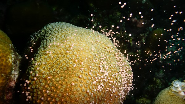
So if we want to find out what's going on down in the deep sea, we really need to get down there, see what's there and start to explore. This is some spectacular footage coming from a seamount about a kilometer deep in international waters in the equatorial Atlantic, far from land. You're amongst the first people to see this bit of the seafloor, along with my research team. You're probably seeing new species. We don't know. You'd have to collect the samples and do some very intense taxonomy. You can see beautiful bubblegum corals. There are brittle stars growing on these corals. Those are things that look like tentacles coming out of corals. There are corals made of different forms of calcium carbonate growing off the basalt of this massive undersea mountain, and the dark sort of stuff, those are fossilized corals, and we're going to talk a little more about those as we travel back in time.
Si queremos saber lo que pasa en las profundidades del mar, realmente debemos llegar allí, para ver lo que hay y empezar a explorar. Esto es algo de lo espectacular que hay en una montaña marina alrededor de 1 km de profundidad en aguas internacionales en el Atlántico ecuatorial, lejos de la tierra. Uds. están entre los primeros en ver este espacio del fondo marino, junto con mi equipo de investigación. Probablemente estén viendo nuevas especies. No sabemos. Debemos recoger las muestras y hacer una intensa taxonomía. Se pueden ver hermosos corales de goma de mascar. Hay estrellas de mar que crecen en estos corales. Esas son cosas que se parecen a los tentáculos que salen de los corales. Hay corales con diferentes formas de carbonato de calcio que crecen fuera del basalto de esta enorme montaña submarina, y esas cosas oscuras son corales fosilizados, y hablaré un poco más sobre ellos al viajar atrás en el tiempo.
To do that, we need to charter a research boat. This is the James Cook, an ocean-class research vessel moored up in Tenerife. Looks beautiful, right? Great, if you're not a great mariner. Sometimes it looks a little more like this. This is us trying to make sure that we don't lose precious samples. Everyone's scurrying around, and I get terribly seasick, so it's not always a lot of fun, but overall it is.
Para hacer eso, hay que alquilar un barco de investigación. Es el James Cook, un buque de investigación para el océano amarrado en Tenerife. Se ve hermoso, ¿verdad? Grande, si no eres un gran navegante. A veces se ve un poco de la misma familia. Somos nosotros, asegurándonos de no perder muestras preciosas. Todo el mundo está corriendo, y salí terriblemente mareada, lo que no siempre es muy divertido, pero en general sí lo es.
So we've got to become a really good mapper to do this. You don't see that kind of spectacular coral abundance everywhere. It is global and it is deep, but we need to really find the right places. We just saw a global map, and overlaid was our cruise passage from last year. This was a seven-week cruise, and this is us, having made our own maps of about 75,000 square kilometers of the seafloor in seven weeks, but that's only a tiny fraction of the seafloor. We're traveling from west to east, over part of the ocean that would look featureless on a big-scale map, but actually some of these mountains are as big as Everest. So with the maps that we make on board, we get about 100-meter resolution, enough to pick out areas to deploy our equipment, but not enough to see very much. To do that, we need to fly remotely-operated vehicles about five meters off the seafloor. And if we do that, we can get maps that are one-meter resolution down thousands of meters. Here is a remotely-operated vehicle, a research-grade vehicle. You can see an array of big lights on the top. There are high-definition cameras, manipulator arms, and lots of little boxes and things to put your samples.
Tenemos que convertirnos en buenos cartógrafos para hacer esto. No se ve esa espectacular abundancia de coral en todas partes. Es global y es profunda, pero hay que encontrar los lugares correctos. Acabamos de ver un mapa del mundo, y, sobrepuesto, nuestro crucero del año pasado. Fue un crucero de siete semanas, y aquí nosotros tras haber hecho nuestros propios mapas de unos 75 000 km cuadrados del fondo marino en siete semanas, pero eso es solo una pequeña fracción de los fondos marinos. Viajamos de oeste a este, en una parte del océano sin rasgos en un mapa de gran escala, pero en realidad algunas de estas montañas son tan grandes como el Everest. Así que con los mapas que hacemos a bordo, obtenemos una resolución de unos 100 metros, lo suficiente para seleccionar zonas donde desplegar nuestros equipos, pero no lo suficiente como para ver mucho. Para hacer eso, tenemos que operar con vehículos a control remoto, a unos cinco metros del suelo marino. Y, al hacerlo, obtenemos mapas de la resolución de un metro a miles de metros. Aquí un vehículo operado por control remoto, un vehículo con alta precisión. Se puede ver una serie de grandes luces en la parte superior. Hay cámaras de alta definición, brazos manipuladores, y pequeñas cajas y cosas donde poner las muestras.
Here we are on our first dive of this particular cruise, plunging down into the ocean. We go pretty fast to make sure the remotely operated vehicles are not affected by any other ships. And we go down, and these are the kinds of things you see. These are deep sea sponges, meter scale. This is a swimming holothurian -- it's a small sea slug, basically. This is slowed down. Most of the footage I'm showing you is speeded up, because all of this takes a lot of time. This is a beautiful holothurian as well. And this animal you're going to see coming up was a big surprise. I've never seen anything like this and it took us all a bit surprised. This was after about 15 hours of work and we were all a bit trigger-happy, and suddenly this giant sea monster started rolling past. It's called a pyrosome or colonial tunicate, if you like. This wasn't what we were looking for. We were looking for corals, deep sea corals. You're going to see a picture of one in a moment. It's small, about five centimeters high. It's made of calcium carbonate, so you can see its tentacles there, moving in the ocean currents. An organism like this probably lives for about a hundred years. And as it grows, it takes in chemicals from the ocean. And the chemicals, or the amount of chemicals, depends on the temperature; it depends on the pH, it depends on the nutrients. And if we can understand how these chemicals get into the skeleton, we can then go back, collect fossil specimens, and reconstruct what the ocean used to look like in the past. And here you can see us collecting that coral with a vacuum system, and we put it into a sampling container. We can do this very carefully, I should add.
Aquí en nuestra primera inmersión de este crucero en particular, cayendo en el océano. Vamos muy rápido para asegurarnos de que los vehículos a control remoto no se ven afectados por otros buques. Y nos metemos, y vemos estas cosas. Estas son esponjas de aguas profundas, a escala de un metro. Se trata de una holoturia, es una pequeña babosa marina. Esto está a cámara lenta. Muchas de las imágenes que muestro están aceleradas, porque todo esto lleva mucho tiempo. Esta es una hermosa holoturia también. Y este animal que van a ver fue una gran sorpresa. Nunca he visto nada como esto y nos dejó a todos sorprendidos. Esto fue tras de 15 horas de trabajo y todos estábamos algo gatillo fácil, y de repente este monstruo de mar gigante comenzó a pasar rodando. Se llama pirosoma o tunicado colonial, si lo desean. Esto no era lo que buscábamos. Estábamos buscando corales, corales de aguas profundas. Verán una foto de uno en un momento. Es pequeño, unos 5 cm de altura. Está hecho de carbonato de calcio, pueden ver sus tentáculos allí, que se mueve en las corrientes oceánicas. Un organismo como este, probablemente, vive cien años. Y a medida que crece, necesita químicos del océano. Y los químicos, o la cantidad de químicos, depende de la temperatura; depende del pH, depende de los nutrientes. Y si podemos entender cómo estos químicos entran en el esqueleto, entonces podemos volver atrás, recoger muestras fósiles, y reconstruir cómo era el océano en el pasado. Y aquí se nos puede ver recogiendo el coral con un sistema de vacío, y lo ponemos en un recipiente de muestreo. Hay que hacer esto con mucho cuidado, debo añadir.
Some of these organisms live even longer. This is a black coral called Leiopathes, an image taken by my colleague, Brendan Roark, about 500 meters below Hawaii. Four thousand years is a long time. If you take a branch from one of these corals and polish it up, this is about 100 microns across. And Brendan took some analyses across this coral -- you can see the marks -- and he's been able to show that these are actual annual bands, so even at 500 meters deep in the ocean, corals can record seasonal changes, which is pretty spectacular.
Algunos de estos organismos viven más tiempo. Este es un coral negro, el Leiopathes, una foto tomada por mi colega, Brendan Roark, a unos 500 m por debajo de Hawái. 4000 años es mucho tiempo. Si pulimos una rama de estos corales, es de unas 100 micras de diámetro. Y Brendan tomó algunos análisis en este coral -- pueden ver las marcas -- y pudo demostrar que estos son bandas anuales reales, por lo que incluso a 500 m de profundidad en el océano, los corales pueden registrar cambios estacionales, algo bastante espectacular.
But 4,000 years is not enough to get us back to our last glacial maximum. So what do we do? We go in for these fossil specimens. This is what makes me really unpopular with my research team. So going along, there's giant sharks everywhere, there are pyrosomes, there are swimming holothurians, there's giant sponges, but I make everyone go down to these dead fossil areas and spend ages kind of shoveling around on the seafloor. And we pick up all these corals, bring them back, we sort them out. But each one of these is a different age, and if we can find out how old they are and then we can measure those chemical signals, this helps us to find out what's been going on in the ocean in the past.
Pero 4000 años no es suficiente para ir de nuevo a nuestro último máximo glacial. Entonces ¿qué hacemos? Vamos a por estos especímenes fósiles. Esto me hace muy impopular en mi equipo de investigación. Así que continuando, hay tiburones gigantes en todas partes, hay pirosomas, hay holoturias, hay esponjas gigantes, pero hago que todos desciendan a estas zonas muertas fósiles y pasamos siglos paleando en el fondo marino. Y recogemos todos estos corales, y los clasificamos al volver. Sin embargo, cada uno de ellos tiene una edad diferente, y si podemos averiguar la edad que tienen entonces podemos medir esas señales químicas, esto nos ayuda a descubrir lo que ha pasado en el océano en el pasado.
So on the left-hand image here, I've taken a slice through a coral, polished it very carefully and taken an optical image. On the right-hand side, we've taken that same piece of coral, put it in a nuclear reactor, induced fission, and every time there's some decay, you can see that marked out in the coral, so we can see the uranium distribution. Why are we doing this? Uranium is a very poorly regarded element, but I love it. The decay helps us find out about the rates and dates of what's going on in the ocean. And if you remember from the beginning, that's what we want to get at when we're thinking about climate. So we use a laser to analyze uranium and one of its daughter products, thorium, in these corals, and that tells us exactly how old the fossils are.
La imagen de la izquierda aquí, hice una rebanada a través de un coral, pulido con mucho cuidado y tomé una foto óptica. Al lado derecho, esa misma pieza de coral, la pusimos en un reactor nuclear, fisión inducida, y cada vez que hay un poco de decadencia, se puede ver lo que marca el coral, por lo que podemos ver la distribución de uranio. ¿Por qué hacemos esto? El uranio es un elemento muy mal considerado, pero me encanta. La decadencia ayuda a averiguar los plazos y las fechas de lo que sucede en el océano. Y si recuerdan el principio, eso es lo que queremos conseguir cuando pensamos en el clima. Por eso usamos un láser para analizar el uranio y uno de sus productos de desintegración, el torio, en estos corales, nos dice exactamente la edad de los fósiles.
This beautiful animation of the Southern Ocean I'm just going to use illustrate how we're using these corals to get at some of the ancient ocean feedbacks. You can see the density of the surface water in this animation by Ryan Abernathey. It's just one year of data, but you can see how dynamic the Southern Ocean is. The intense mixing, particularly the Drake Passage, which is shown by the box, is really one of the strongest currents in the world coming through here, flowing from west to east. It's very turbulently mixed, because it's moving over those great big undersea mountains, and this allows CO2 and heat to exchange with the atmosphere in and out. And essentially, the oceans are breathing through the Southern Ocean. We've collected corals from back and forth across this Antarctic passage, and we've found quite a surprising thing from my uranium dating: the corals migrated from south to north during this transition from the glacial to the interglacial. We don't really know why, but we think it's something to do with the food source and maybe the oxygen in the water.
Esta hermosa animación del Océano Antártico la uso para ilustrar cómo usamos estos corales para llegar a algunas de las antiguas respuestas del océano. Se puede ver la densidad de las aguas superficiales en esta animación de Ryan Abernathey. Es solo un año de datos, pero se puede ver la forma dinámica del Océano Antártico. La mezcla intensa, en particular el pasaje de Drake, que se muestra por el cuadro, es realmente una de las corrientes más fuertes del mundo que entra por aquí, que fluye de oeste a este. Es una mezcla muy turbulenta, porque se mueve sobre esas grandes montañas submarinas, y permite el intercambio de CO2 y calor con la atmósfera hacia dentro y fuera. Y, esencialmente, los océanos respiran a través del Océano Antártico. Hemos recopilado los corales de ambos lados de este pasaje de la Antártida, y hemos encontrado algo bastante sorprendente al fechar el uranio: los corales migraron de sur a norte durante la transición de la era glacial a la interglacial. No se sabe muy bien por qué, pero creemos que está relacionado con la fuente de alimento y tal vez con el oxígeno en el agua.
So here we are. I'm going to illustrate what I think we've found about climate from those corals in the Southern Ocean. We went up and down sea mountains. We collected little fossil corals. This is my illustration of that. We think back in the glacial, from the analysis we've made in the corals, that the deep part of the Southern Ocean was very rich in carbon, and there was a low-density layer sitting on top. That stops carbon dioxide coming out of the ocean. We then found corals that are of an intermediate age, and they show us that the ocean mixed partway through that climate transition. That allows carbon to come out of the deep ocean. And then if we analyze corals closer to the modern day, or indeed if we go down there today anyway and measure the chemistry of the corals, we see that we move to a position where carbon can exchange in and out. So this is the way we can use fossil corals to help us learn about the environment.
Aquí estamos. Voy a ilustrar lo que creo que hemos descubierto sobre el clima a partir de esos corales en el Océano Antártico. Subimos y bajamos montañas de mar. Recogimos pequeños corales fósiles. Este es mi ejemplo de ello. Pensamos que volvíamos a la era glaciar, a partir del análisis que hemos hecho en los corales, que la parte profunda del Océano Antártico era muy rica en carbono, y había una capa de baja densidad que se asienta en la parte superior. Que detiene el dióxido de carbono que sale del océano. Luego encontramos que los corales de edad intermedia, muestran que el océano se mezcla en un punto intermedio de la transición climática. Eso le permite al carbono salir de las profundidades del océano. Y luego, si analizamos los corales de los tiempos modernos, o incluso si bajamos allí hoy de todos modos y medimos la química de los corales, pasamos a una posición donde el carbono se intercambia de entrada y salida. Así que esta es la manera en que podemos usar los corales fósiles para ayudarnos a aprender sobre el medio ambiente.
So I want to leave you with this last slide. It's just a still taken out of that first piece of footage that I showed you. This is a spectacular coral garden. We didn't even expect to find things this beautiful. It's thousands of meters deep. There are new species. It's just a beautiful place. There are fossils in amongst, and now I've trained you to appreciate the fossil corals that are down there.
Por eso quiero dejarles con esta última diapositiva. Es una imagen fija de la primera pieza de material de archivo que ya mostré. Se trata de un espectacular jardín de coral. Ni siquiera nos esperamos encontrar cosas tan hermosas. Está a miles de metros de profundidad. Hay nuevas especies. Es un lugar hermoso. Hay fósiles entre ellos, y ahora me he entrenado para apreciar los corales fósiles que están ahí abajo.
So next time you're lucky enough to fly over the ocean or sail over the ocean, just think -- there are massive sea mountains down there that nobody's ever seen before, and there are beautiful corals.
Así que la próxima vez que tengan la suerte de volar sobre el océano o navegar sobre el océano, solo piensen que hay enormes montañas en el mar profundo que nadie ha visto nunca antes, y hay hermosos corales.
Thank you.
Gracias.
(Applause)
(Aplausos)