So I'm here to talk to you about the walkable city. What is the walkable city? Well, for want of a better definition, it's a city in which the car is an optional instrument of freedom, rather than a prosthetic device. And I'd like to talk about why we need the walkable city, and I'd like to talk about how to do the walkable city.
Ik ga het hebben over de beloopbare stad. Wat is de beloopbare stad? Bij gebrek aan een betere definitie is het een stad waarin de auto een optioneel instrument voor vrijheid is en geen prothetisch apparaat. Ik wil graag praten over waarom de beloopbare stad nodig is en hoe de beloopbare stad te maken is.
Most of the talks I give these days are about why we need it, but you guys are smart. And also I gave that talk exactly a month ago, and you can see it at TED.com. So today I want to talk about how to do it. In a lot of time thinking about this, I've come up with what I call the general theory of walkability. A bit of a pretentious term, it's a little tongue-in-cheek, but it's something I've thought about for a long time, and I'd like to share what I think I've figured out.
Bij de meeste talks die ik doe, begin ik met waarom we dat nodig hebben. Maar jullie zijn slim. En die talk heb ik precies een maand geleden gegeven en je kunt hem nakijken op TED.com. Vandaag wil ik praten over het 'hoe'. Ik heb hier veel over nagedacht en heb een algemene theorie van beloopbaarheid ontwikkeld. Een beetje een pretentieuze term en niet al te serieus bedoeld, maar ik heb er lang over nagedacht en ik wil graag delen wat ik denk dat ik uitgevogeld heb.
In the American city, the typical American city -- the typical American city is not Washington, DC, or New York, or San Francisco; it's Grand Rapids or Cedar Rapids or Memphis -- in the typical American city in which most people own cars and the temptation is to drive them all the time, if you're going to get them to walk, then you have to offer a walk that's as good as a drive or better. What does that mean? It means you need to offer four things simultaneously: there needs to be a proper reason to walk, the walk has to be safe and feel safe, the walk has to be comfortable and the walk has to be interesting. You need to do all four of these things simultaneously, and that's the structure of my talk today, to take you through each of those.
In de typisch Amerikaanse stad -- en dat is niet Washington DC of New York of San Francisco, maar Grand Rapids of Cedar Rapids of Memphis -- in de typische Amerikaanse stad waar de meeste mensen een auto hebben en geneigd zijn om daar de hele tijd in te rijden, als je wilt dat mensen daar gaan lopen, moet zo'n wandeling minstens net zo goed zijn als een autorit. Wat houdt dat in? Dat je vier dingen tegelijk moet aanbieden: er moet een goede reden zijn om te lopen, het lopen moet veilig zijn en voelen, het lopen moet aangenaam zijn, en het lopen moet interessant zijn. Je moet al deze vier dingen tegelijk doen. Dat is ook hoe ik mijn talk vormgeef. Ik neem jullie mee door de vier stappen.
The reason to walk is a story I learned from my mentors, Andrés Duany and Elizabeth Plater-Zyberk, the founders of the New Urbanism movement. And I should say half the slides and half of my talk today I learned from them. It's the story of planning, the story of the formation of the planning profession. When in the 19th century people were choking from the soot of the dark, satanic mills, the planners said, hey, let's move the housing away from the mills. And lifespans increased immediately, dramatically, and we like to say the planners have been trying to repeat that experience ever since.
De reden om te lopen heb ik geleerd van mijn mentoren, Andrés Duany en Elizabeth Plater-Zyberk, de oprichters van de New Urbanism-beweging. Ik moet erbij zeggen dat ik de helft van mijn slides en mijn talk van hen geleerd heb. Het verhaal gaat over planologie, het verhaal gaat over het ontstaan van het beroep planoloog. Toen in de 19e eeuw mensen stikten in de roet van donkere, satanische fabrieken, zeiden de planologen: "Hé, laten we de huizen weghalen bij de fabrieken." Levensduren werden verlengd, onmiddellijk en dramatisch, en we kunnen wel zeggen dat planologen sindsdien proberen die ervaring te herhalen.
So there's the onset of what we call Euclidean zoning, the separation of the landscape into large areas of single use. And typically when I arrive in a city to do a plan, a plan like this already awaits me on the property that I'm looking at. And all a plan like this guarantees is that you will not have a walkable city, because nothing is located near anything else. The alternative, of course, is our most walkable city, and I like to say, you know, this is a Rothko, and this is a Seurat. It's just a different way -- he was the pointilist -- it's a different way of making places. And even this map of Manhattan is a bit misleading because the red color is uses that are mixed vertically.
Dat is het begin van wat we Euclidisch plannen noemen, het opdelen van het landschap in grote gebieden met één enkel doel. Meestal als ik in een stad aankom om een plan te maken, ligt er al een plan klaar voor het gebied waar ik naar kijk. En wat zo'n plan garandeert, is dat je geen beloopbare stad krijgt, want niets is in de buurt. Het alternatief is natuurlijk onze meest beloopbare stad. Ik zeg altijd graag: dit is een Rothko en dit is een Seurat. Het is een andere manier -- hij was een pointilist -- een andere manier om omgevingen te maken. Zelfs deze kaart van Manhattan is wat misleidend, want de rode kleur geeft verticaal gemengd gebruik aan.
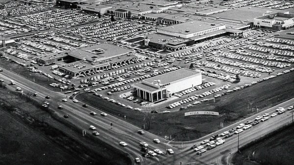
So this is the big story of the New Urbanists -- to acknowledge that there are only two ways that have been tested by the thousands to build communities, in the world and throughout history. One is the traditional neighborhood. You see here several neighborhoods of Newburyport, Massachusetts, which is defined as being compact and being diverse -- places to live, work, shop, recreate, get educated -- all within walking distance. And it's defined as being walkable. There are lots of small streets. Each one is comfortable to walk on. And we contrast that to the other way, an invention that happened after the Second World War, suburban sprawl, clearly not compact, clearly not diverse, and it's not walkable, because so few of the streets connect, that those streets that do connect become overburdened, and you wouldn't let your kid out on them. And I want to thank Alex Maclean, the aerial photographer, for many of these beautiful pictures that I'm showing you today.
Dus dit is het grote verhaal van de New Urbanists: aanvaarden dat er slechts twee manieren zijn die zijn getest door duizenden om gemeenschappen te bouwen -- in de wereld en in de geschiedenis. De ene is de traditionele buurt. Hier zie je zulke buurten in Newburyport, Massachusetts. Ze worden gezien als compact en divers met ruimtes om te leven, werken, winkelen, recreëren, leren, allemaal op loopafstand. En het wordt gezien als beloopbaar. Er zijn veel kleine straatjes. Allemaal prettig om op te lopen. Dat vergelijken we met de andere manier -- een uitvinding van na de Tweede Wereldoorlog, stedelijke woekering, duidelijk niet compact, niet divers en niet beloopbaar. Weinig straten sluiten op elkaar aan en de straten die wel aansluiten, worden overbelast, dus daar laat je je kinderen niet lopen. Ik wil Alex Maclean, een luchtfotograaf, bedanken voor deze mooie foto's die ik vandaag laat zien.
So it's fun to break sprawl down into its constituent parts. It's so easy to understand, the places where you only live, the places where you only work, the places where you only shop, and our super-sized public institutions. Schools get bigger and bigger, and therefore, further and further from each other. And the ratio of the size of the parking lot to the size of the school tells you all you need to know, which is that no child has ever walked to this school, no child will ever walk to this school. The seniors and juniors are driving the freshmen and the sophomores, and of course we have the crash statistics to prove it.
Het is leuk om die woekering op te breken in de bestanddelen. Het is simpel te begrijpen: de plekken waar je enkel woont, de plekken waar je enkel werkt, de plekken waar je enkel winkelt en onze uit de kluiten gewassen openbare instellingen. Scholen worden steeds groter en liggen dus steeds verder bij elkaar vandaan. De verhouding tussen de omvang van de parkeerplaats en de omvang van de school is alleszeggend. Geen kind is ooit naar deze school gelopen. Geen kind zal ooit naar deze school lopen. De ouderejaars rijden de jongerejaars, de ongevallencijfers tonen dit aan.
And then the super-sizing of our other civic institutions like playing fields -- it's wonderful that Westin in the Ft. Lauderdale area has eight soccer fields and eight baseball diamonds and 20 tennis courts, but look at the road that takes you to that location, and would you let your child bike on it? And this is why we have the soccer mom now. When I was young, I had one soccer field, one baseball diamond and one tennis court, but I could walk to it, because it was in my neighborhood.
En dan de enorme groei van de rest van onze openbare instellingen, zoals sportvelden. Het is geweldig dat Westin in Fort Lauderdale acht voetbalvelden en acht honkbalvelden en twintig tennisbanen heeft. Maar kijk eens naar de weg die erheen leidt. Zou je je kind daar laten fietsen? Daarom bestaat nu de voetbalmoeder. Toen ik jong was, was er één voetbalveld, één honkbalveld en één tennisbaan, maar ik kon erheen lopen, want het was in mijn buurt.
Then the final part of sprawl that everyone forgot to count: if you're going to separate everything from everything else and reconnect it only with automotive infrastructure, then this is what your landscape begins to look like. The main message here is: if you want to have a walkable city, you can't start with the sprawl model. you need the bones of an urban model. This is the outcome of that form of design, as is this. And this is something that a lot of Americans want. But we have to understand it's a two-part American dream. If you're dreaming for this, you're also going to be dreaming of this, often to absurd extremes, when we build our landscape to accommodate cars first. And the experience of being in these places --
Het laatste deel van woekering is wat iedereen vergat te tellen: als je alles scheidt van al het andere en het weer verbindt met een net van autowegen dan gaat je landschap er zo uitzien. De boodschap is: als je een beloopbare stad wilt, kan je niet beginnen met het woekermodel. Je hebt een stedelijk model als geraamte nodig. Dat is het restultaat van deze ontwerpmethode en dit ook. Veel Amerikanen willen zoiets als dit. Maar die Amerikaanse droom heeft twee gezichten. Als je hiervan droomt, droom je ook hiervan. Vaak tot in absurde extremen, als we ons landschap bouwen om eerst auto's te accommoderen. En de ervaring in deze plaatsen --
(Laughter)
- (Gelach) - Dit is niet gephotoshopt.
This is not Photoshopped. Walter Kulash took this slide. It's in Panama City. This is a real place. And being a driver can be a bit of a nuisance, and being a pedestrian can be a bit of a nuisance in these places. This is a slide that epidemiologists have been showing for some time now,
Walter Kulash heeft dit beeld gemaakt. Dit is in Panama Stad. Het is een echte plek. Autorijden kan best vervelend zijn en lopen kan best vervelend zijn op deze plekken. Dit is een slide die epidemologen al een tijdje laten zien.
(Laughter)
(Gelach)
The fact that we have a society where you drive to the parking lot to take the escalator to the treadmill shows that we're doing something wrong. But we know how to do it better.
Onze maatschappij waarin je rijdt naar een parkeerplaats om de roltrap te nemen naar een loopband, laat zien dat we iets verkeerd doen. Maar we weten hoe het beter kan.
Here are the two models contrasted. I show this slide, which has been a formative document of the New Urbanism now for almost 30 years, to show that sprawl and the traditional neighborhood contain the same things. It's just how big are they, how close are they to each other, how are they interspersed together and do you have a street network, rather than a cul-de-sac or a collector system of streets?
Dit zijn de twee modellen naast elkaar. Ik toon deze slide, een scheppend document van het New Urbanism, al bijna 30 jaar, om te laten zien dat woekering en de traditionele buurt dezelfde elementen bevatten. Het verschil is de omvang, hoe dicht ze bij elkaar liggen, hoe ze elkaar afwisselen en of er een netwerk is van straten of een systeem met doodlopende en centrale wegen.
So when we look at a downtown area, at a place that has a hope of being walkable, and mostly that's our downtowns in America's cities and towns and villages, we look at them and say we want the proper balance of uses. So what is missing or underrepresented? And again, in the typical American cities in which most Americans live, it is housing that is lacking. The jobs-to-housing balance is off. And you find that when you bring housing back, these other things start to come back too, and housing is usually first among those things. And, of course, the thing that shows up last and eventually is the schools, because the people have to move in, the young pioneers have to move in, get older, have kids and fight, and then the schools get pretty good eventually.
Als wij kijken naar een stadscentrum, naar een plek die mogelijk beloopbaar is, en dat is meestal het centrum in Amerikaanse steden en dorpen, zeggen we: "We willen een echte balans in gebruik." Dus wat is er te weinig of ontbreekt helemaal? Nogmaals, in de typisch Amerikaanse steden waar de meeste Amerikanen wonen, ontbreken de woningen. De balans tussen werk en wonen is scheef. Je ziet dat als je de woningen terugbrengt, die andere dingen ook gaan terugkomen. Woningen zijn meestal het eerste. Als laatste komen de scholen, want mensen moeten er komen wonen, de jonge pioniers komen er wonen, worden ouder, krijgen kinderen en krijgen ruzie en uiteindelijk worden de scholen best goed.
The other part of this part, the useful city part, is transit, and you can have a perfectly walkable neighborhood without it. But perfectly walkable cities require transit, because if you don't have access to the whole city as a pedestrian, then you get a car, and if you get a car, the city begins to reshape itself around your needs, and the streets get wider and the parking lots get bigger and you no longer have a walkable city. So transit is essential. But every transit experience, every transit trip, begins or ends as a walk, and so we have to remember to build walkability around our transit stations.
Het andere onderdeel hiervan, van de nuttige stad, is openbaar vervoer. Je kunt een perfect beloopbare buurt hebben zonder openbaar vervoer. Maar perfect beloopbare steden hebben openbaar vervoer nodig, want als je de hele stad niet als voetganger kunt bereiken, koop je een auto. En als je een auto koopt, gaat de stad zich naar jouw behoeften vormen. Straten worden breder en parkeerplaatsen worden groter. Dan is de stad niet meer beloopbaar. Vervoer is onmisbaar. Maar iedere reisbeweging, iedere trip, begint of eindigt lopend. Dus we moeten beloopbaarheid inbouwen in onze ov-stations.
Next category, the biggest one, is the safe walk. It's what most walkability experts talk about. It is essential, but alone not enough to get people to walk. And there are so many moving parts that add up to a walkable city.
De volgende categorie, de belangrijkste, is veilig lopen. Daar praten de meeste voetgangersexperts over. Het is essentieel, maar op zich niet genoeg om mensen te laten lopen. Er zijn zo veel bewegende delen die samen de beloopbare stad maken.
The first is block size. This is Portland, Oregon, famously 200-foot blocks, famously walkable. This is Salt Lake City, famously 600-foot blocks, famously unwalkable. If you look at the two, it's almost like two different planets, but these places were both built by humans and in fact, the story is that when you have a 200-foot block city, you can have a two-lane city, or a two-to-four lane city, and a 600-foot block city is a six-lane city, and that's a problem. These are the crash statistics. When you double the block size -- this was a study of 24 California cities -- when you double the block size, you almost quadruple the number of fatal accidents on non-highway streets.
Het eerste is de blokgrootte. Dit is Portland, Oregan, beroemd om zijn 60-meterblokken, een beroemde wandelstad. Dit is Salt Lake City, beroemd om zijn 200-meterblokken, een beroerde wandelstad. Het zijn net twee verschillende planeten, maar ze zijn allebei gebouwd door mensen. Als je een stad hebt met 60-meterblokken, kun je een stad maken met twee- of met vierbaanswegen. Een stad met 200-meterblokken heeft zesbaanswegen nodig. En dat is een probleem. Dit zijn de ongevallencijfers. Als je de blokgrootte verdubbelt -- dit is een onderzoek in 24 Californische steden -- als je de blokgrootte verdubbelt, verviervoudigt bijna het aantal fatale ongevallen op niet-snelwegen.
So how many lanes do we have? This is where I'm going to tell you what I tell every audience I meet, which is to remind you about induced demand. Induced demand applies both to highways and to city streets. And induced demand tells us that when we widen the streets to accept the congestion that we're anticipating, or the additional trips that we're anticipating in congested systems, it is principally that congestion that is constraining demand, and so that the widening comes, and there are all of these latent trips that are ready to happen. People move further from work and make other choices about when they commute, and those lanes fill up very quickly with traffic, so we widen the street again, and they fill up again. And we've learned that in congested systems, we cannot satisfy the automobile.
Dus hoeveel banen hebben we? Nu ga ik jullie vertellen wat ik ieder publiek vertel. Ik wijs jullie op latente vraag. Latente vraag slaat op zowel snelwegen als stadswegen. Latente vraag stelt dat wanneer we de straten verbreden om de files die we voorzien op te vangen of de extra reisbewegingen die we verwachten in drukke systemen, dan is het die verstopping die de vraag beperkt. Dus als de verbreding plaatsvindt, zullen al die latente reisbewegingen ook plaatsvinden. Mensen gaan verder van werk wonen, kiezen andere momenten om te forezen en die banen vullen zich weer snel met verkeer. Dus we verbreden de straat weer en hij vult zich weer. We hebben geleerd dat we in verstopte systemen de auto niet tevreden kunnen stellen.
This is from Newsweek Magazine -- hardly an esoteric publication: "Today's engineers acknowledge that building new roads usually makes traffic worse." My response to reading this was, may I please meet some of these engineers, because these are not the ones that I -- there are great exceptions that I'm working with now -- but these are not the engineers one typically meets working in a city, where they say, "Oh, that road is too crowded, we need to add a lane." So you add a lane, and the traffic comes, and they say, "See, I told you we needed that lane." This applies both to highways and to city streets if they're congested.
Dit komt uit Newsweek Magazine, zeker geen esotherisch blad: "Moderne ingenieurs erkennen dat het bouwen van wegen het verkeer meestal verslechtert." Mijn reactie hierop was: "Ik zou die ingenieurs graag ontmoeten." Want dit zijn niet degenen -- ik werk nu met enkele grote uitzonderingen -- maar zulke ingenieurs kom je meestal niet tegen als je in de stad werkt. Daar zeggen ze: "Die weg is te druk, we moeten nog een baan aanleggen." Dan leg je die baan aan, er komt meer verkeer en dan zeggen ze: "Zie je wel, die baan was nodig." Dit geldt zowel voor snelwegen als voor stadswegen die verstopt zijn.
But the amazing thing about most American cities that I work in, the more typical cities, is that they have a lot of streets that are actually oversized for the congestion they're currently experiencing. This was the case in Oklahoma City, when the mayor came running to me, very upset, because they were named in Prevention Magazine the worst city for pedestrians in the entire country. Now that can't possibly be true, but it certainly is enough to make a mayor do something about it. We did a walkability study, and what we found, looking at the car counts on the street -- these are 3,000-, 4,000-, 7,000-car counts and we know that two lanes can handle 10,000 cars per day. Look at these numbers -- they're all near or under 10,000 cars, and these were the streets that were designated in the new downtown plan to be four lanes to six lanes wide. So you had a fundamental disconnect between the number of lanes and the number of cars that wanted to use them.
Maar het bizarre aan de meeste Amerikaanse steden waar ik werk -- de meer typische steden -- is dat ze een heleboel straten hebben die te breed zijn voor de files die ze nu hebben. Dat was zo in Oklahoma City, waar de burgemeester overstuur naar me toe kwam, omdat ze in Prevention Magazine de slechtste stad voor voetgangers in het hele land waren genoemd. Dat kan bijna niet waar zijn, maar het was genoeg om de burgemeester er iets aan te laten doen. We deden een loop-onderzoek. We keken naar het aantal auto's op de weg, dit waren er 3.000, 4.000, 7.000. En we weten dat tweebaanswegen wel 10.000 auto's per dag aankunnen. Merk op dat deze aantallen allemaal rond of onder de 10.000 auto's liggen. Toch waren al deze straten in het nieuwe plan aangemerkt om vier- tot zesbaanswegen te worden. Er was een fundamentele ontkoppeling tussen het aantal banen en het aantal auto's dat ze wilde gebruiken.
So it was my job to redesign every street in the downtown from curb face to curb face, and we did it for 50 blocks of streets, and we're rebuilding it now. So a typical oversized street to nowhere is being narrowed, and now under construction, and the project is half done. The typical street like this, you know, when you do that, you find room for medians. You find room for bike lanes. We've doubled the amount of on-street parking. We've added a full bike network where one didn't exist before.
Dus het was mijn taak om iedere straat in het centrum te herzien, van stoep tot stoep. We deden dat voor 50 blokken en we zijn ze nu aan het reconstrueren. Een bovenmaatse weg die nergens naartoe leidt, wordt vernauwd. Ze zijn nu aan het werk en het project is halverwege. Op een straat zoals deze, als je dat doet, vind je ruimte voor middenbermen. Je vindt ruimte voor fietspaden. Het aantal parkeerplaatsen is verdubbeld. We hebben een volledig fietsnetwerk toegevoegd waar er geen was.
But not everyone has the money that Oklahoma City has, because they have an extraction economy that's doing quite well. The typical city is more like Cedar Rapids, where they have an all four-lane system, half one-way system. And it's a little hard to see, but what we've done -- what we're doing; it's in process right now, it's in engineering right now -- is turning an all four-lane system, half one-way into an all two-lane system, all two-way, and in so doing, we're adding 70 percent more on-street parking, which the merchants love, and it protects the sidewalk. That parking makes the sidewalk safe, and we're adding a much more robust bicycle network.
Maar niet iedereen heeft het geld dat Oklahoma City heeft, want zij hebben een goed draaiende extractie-economie. Een typische stad is meer zoals Cedar Rapids, waar ze een vierbaanssysteem hebben, half eenrichtingsverkeer. Het is lastig om te zien, maar wat we hebben gedaan -- wat we nu doen, het project is nu in uitvoering -- we maken van een vierbaanssysteem, half eenrichting, een tweebaanssysteem, helemaal tweerichting. Daarmee creëeren we 70% meer parkeerplaatsen langs de weg, wat de middenstand fijn vindt en het beschermt de stoepen. Parkeerplaatsen maken stoepen veilig. En we voegen een veel robuuster fietsnetwerk toe.
Then the lanes themselves. How wide are they? That's really important. The standards have changed such that, as Andrés Duany says, the typical road to a subdivision in America allows you to see the curvature of the Earth.
Dan de banen zelf. Hoe breed zijn die? Dat is erg belangrijk. De standaarden zijn zo veranderd dat, zoals Andrés Duany zegt, je op een typische weg naar een buitenwijk in Amerika de kromming van de aarde kunt zien.
(Laughter)
(Gelach)
This is a subdivision outside of Washington from the 1960s. Look very carefully at the width of the streets. This is a subdivision from the 1980s. 1960s, 1980s. The standards have changed to such a degree that my old neighborhood of South Beach, when it was time to fix the street that wasn't draining properly, they had to widen it and take away half our sidewalk, because the standards were wider. People go faster on wider streets. People know this. The engineers deny it, but the citizens know it, so that in Birmingham, Michigan, they fight for narrower streets. Portland, Oregon, famously walkable, instituted its "Skinny Streets" program in its residential neighborhood. We know that skinny streets are safer. The developer Vince Graham, in his project I'On, which we worked on in South Carolina, he goes to conferences and he shows his amazing 22-foot roads. These are two-way roads, very narrow rights of way, and he shows this well-known philosopher, who said, "Broad is the road that leads to destruction ... narrow is the road that leads to life."
Dit is een buitenwijk bij Washington in de jaren 60. Kijk naar de breedte van de straten. Dit is een buitenwijk in de jaren 80. Jaren 60, jaren 80. De standaarden zijn zo veranderd dat in mijn oude buurt in South Beach, toen ze de straten moesten repareren omdat de afvoer niet goed werkte, ze de helft van onze trottoirs wegnamen omdat de standaarden breder waren. Mensen rijden sneller op brede wegen. Dat weten we. De ingenieurs ontkennen het, maar burgers weten het. Dus in Birmingham, Michigan, strijden ze voor smallere straten. Portland, Oregon, beroemde wandelstad, voerde het 'Skinny Streets'-programma in voor woonwijken. We weten dat smalle straten veiliger zijn. Ontwikkelaar Vince Graham, met zijn project l'On, waar we aan werkten in South Carolina, toont op congressen zijn geweldige 7-meterwegen. Dit zijn tweerichtingswegen met beperkte toegang. Hij citeert deze bekende filosoof die zei: "Breed is de weg die leidt naar vernietiging, smal is de weg die leidt naar het leven."
(Laughter)
(Gelach)
(Applause)
(Applaus)
This plays very well in the South.
Dat slaat goed aan in het zuiden.
Now: bicycles.
(Gelach)
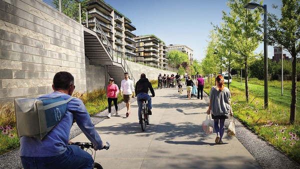
Bicycles and bicycling are the current revolution underway in only some American cities. But where you build it, they come. As a planner, I hate to say that, but the one thing I can say is that bicycle population is a function of bicycle infrastructure. I asked my friend Tom Brennan from Nelson\Nygaard in Portland to send me some pictures of the Portland bike commute. He sent me this. I said, "Was that bike to work day?" He said, "No, that was Tuesday." When you do what Portland did and spend money on bicycle infrastructure -- New York City has doubled the number of bikers in it several times now by painting these bright green lanes. Even automotive cities like Long Beach, California: vast uptick in the number of bikers based on the infrastructure. And of course, what really does it, if you know 15th Street here in Washington, DC -- please meet Rahm Emanuel's new bike lanes in Chicago, the buffered lane, the parallel parking pulled off the curb, the bikes between the parked cars and the curb -- these mint cyclists. If, however, as in Pasadena, every lane is a bike lane, then no lane is a bike lane. And this is the only bicyclist that I met in Pasadena, so ...
Nu: fietsen. Fietsen is de huidige revolutie in slechts een paar Amerikaanse steden. Maar waar je het bouwt, komen ze. Als planoloog zeg ik het niet graag, maar het enige dat ik kan zeggen, is dat fietspopulatie een functie is van fietsinfrastructuur. Ik vroeg mijn vriend Tom Brennan van Nelson\Nygaard in Portland om foto's te sturen van fietsverkeer in Portland. Hij stuurde dit en ik vroeg: "Was het 'Fiets Naar Werk'-Dag?" Hij zei: "Nee, het was dinsdag." Als je doet wat Portland deed en geld steekt in fietsinfrastructuur -- New York heeft het aantal fietsers meermaals verdubbeld door deze felgroene fietsstroken te maken. Zelfs in autosteden zoals Long Beach, California: een enorme toename aan fietsers door de infrastructuur. Wat het 'm natuurlijk echt doet -- als je 15th Street kent, hier in Washington DC -- dit zijn Rahm Emanuels nieuwe fietsstroken in Chicago: de gebufferde strook, de auto's van de stoep af geparkeerd en de fietsers tussen de geparkeerde auto's en de stoep. Deze stroken scheppen fietsers. Als daarentegen, zoals in Pasadena, iedere straat een fietsstraat is, is geen enkele straat een fietsstraat. En dit is de enige fietser die ik tegenkwam in Pasadena, dus...
(Laughter)
(Gelach)
The parallel parking I mentioned -- it's an essential barrier of steel that protects the curb and pedestrians from moving vehicles. This is Ft. Lauderdale; one side of the street, you can park, the other side of the street, you can't. This is happy hour on the parking side. This is sad hour on the other side. And then the trees themselves slow cars down. They move slower when trees are next to the road, and, of course, sometimes they slow down very quickly. All the little details -- the curb return radius. Is it one foot or is it 40 feet? How swoopy is that curb to determine how fast the car goes and how much room you have to cross. And then I love this, because this is objective journalism. "Some say the entrance to CityCenter is not inviting to pedestrians." When every aspect of the landscape is swoopy, is aerodynamic, is stream-form geometrics, it says: "This is a vehicular place." So no one detail, no one speciality, can be allowed to set the stage. And here, you know, this street: yes, it will drain within a minute of the hundred-year storm, but this poor woman has to mount the curb every day.
De parkeerstroken die ik noemde, zijn in feite een stalen barrière die de stoep en voetgangers beschermt tegen bewegende voertuigen. Dit is Fort Lauderdale: aan de ene kant van de weg mag je parkeren, aan de nadere kant niet. Dit is 'happy hour' aan de parkeer-kant. En hetzelfde moment aan de andere kant. Bomen vertragen ook auto's. Auto's rijden langzamer op een weg met bomen. Bomen houden auto's soms ook wel heel plotseling tegen. En de kleine details: de buiging van de straathoek. Is die 30 centimeter of 10 meter? De buiging van de hoek bepaalt hoe snel de auto gaat en hoeveel ruimte je hebt om over te steken. Dit vind ik mooi, want dit is objectieve journalistiek: "Sommigen zeggen dat de CityCenter-ingang niet aantrekkelijk is voor voetgangers." Als het landschap in al zijn facetten vloeiend is, aerodynamisch, gestroomlijnd, zegt het: "Dit is een plek voor auto's." Geen enkel detail mag in zijn eentje de toon aangeven. En hier, deze straat: ja, het riool kan in een minuut een zeldzame superregenbui afvoeren, maar deze arme vrouw moet iedere dag die stoeprand beklimmen.
So then quickly, the comfortable walk has to do with the fact that all animals seek, simultaneously, prospect and refuge. We want to be able to see our predators, but we also want to feel that our flanks are covered. And so we're drawn to places that have good edges, and if you don't supply the edges, people won't want to be there. What's the proper ratio of height to width? Is it one to one? Three to one? If you get beyond one to six, you're not very comfortable anymore. You don't feel enclosed. Now, six to one in Salzburg can be perfectly delightful. The opposite of Salzburg is Houston. The point being the parking lot is the principal problem here. However, missing teeth, those empty lots can be issues as well, and if you have a missing corner because of an outdated zoning code, then you could have a missing nose in your neighborhood. That's what we had in my neighborhood. This was the zoning code that said I couldn't build on that site. As you may know, Washington, DC is now changing its zoning to allow sites like this to become sites like this. We needed a lot of variances to do that. Triangular houses can be interesting to build, but if you get one built, people generally like it. So you've got to fill those missing noses.
Dan nog snel: comfortabel wandelen heeft te maken met het feit dat alle dieren tegelijk uitzicht en beschutting zoeken. We willen roofdieren kunnen zien maar we willen ons ook beschermd voelen. Dus we worden aangetrokken door plaatsen met goede grenzen. En als je niet voorziet in grenzen willen mensen er niet zijn. Wat is de juiste hoogte-breedteverhouding? Een op een? Drie op een? Als je verder gaat dan een op zes is het niet erg comfortabel meer. Je voelt je niet beschermd. Zes op een in Salzburg kan heerlijk aanvoelen. Het tegenovergestelde van Salzburg is Houston. Parkeerplaatsen zijn het hoofdprobleem. Maar net als missende tanden zijn lege plekken ook een probleem. En als de hoek ontbreekt door een achterhaald bestemmingsplan dan mist je buurt zijn 'neus'. Dat was het probleem in mijn buurt. Volgens het bestemmingsplan mocht ik niet bouwen op die plek. Zoals je misschien weet, past Washington zijn bestemmingsplan aan, zodat zulke plekken in zulke plekken kunnen veranderen. Daar waren een hoop uitzonderingen voor nodig. Driehoekige huizen zijn lastig om te bouwen, maar als je er een bouwt, vinden mensen dat meestal leuk. Je moet die ontbrekende neuzen opvullen.
And then, finally, the interesting walk: signs of humanity. We are among the social primates. Nothing interests us more than other people. We want signs of people. So the perfect one-to-one ratio, it's a great thing. This is Grand Rapids, a very walkable city, but nobody walks on this street that connects the two best hotels together, because if on the left, you have an exposed parking deck, and on the right, you have a conference facility that was apparently designed in admiration for that parking deck, then you don't attract that many people. Mayor Joe Riley, in his 10th term, Mayor of Charleston, South Carolina, taught us it only takes 25 feet of building to hide 250 feet of garage. This one I call the Chia Pet Garage. It's in South Beach. That active ground floor.
Tot slot: de boeiende wandeling. Tekenen van menselijkheid. Wij zijn sociale primaten. Niets is zo interessant als andere mensen. We willen andere mensen zien. De perfecte een-op-eenratio is geweldig. Dit is Grand Rapids, een erg beloopbare stad. Maar niemand loopt op deze straat die twee goede hotels met elkaar verbindt. Want links heb je een parkeergarage, en rechts een congrescentrum dat blijkbaar is ontworpen om die parkeergarage te kunnen bewonderen. Dan trek je niet veel mensen aan. De burgemeester van Charleston, South Carolina, Joe Riley toonde dat je met een gebouw van 7 meter 70 meter garage kunt verbergen. Ik noem deze de Chia Pet Garage. Hij ligt in South Beach. Die actieve begane grond.
I want to end with this project that I love to show. It's by Meleca Architects. It's in Columbus, Ohio. To the left is the convention center neighborhood, full of pedestrians. To the right is the Short North neighborhood -- ethnic, great restaurants, great shops, struggling. It wasn't doing very well because this was the bridge, and no one was walking from the convention center into that neighborhood. Well, when they rebuilt the highway, they added an extra 80 feet to the bridge. Sorry -- they rebuilt the bridge over the highway. The city paid 1.9 million dollars, they gave the site to a developer, the developer built this and now the Short North has come back to life. And everyone says, the newspapers, not the planning magazines, the newspapers say it's because of that bridge.
Ik rond af met een project dat ik heel graag laat zien. Het is van Meleca Architects in Columbus, Ohio. Links ligt het congrescentrum, vol voetgangers. Rechts ligt de buurt Short North -- etnisch, goede restaurants, leuke winkels -- worstelend. Het ging niet goed door deze brug. En niemand liep van het congrescentrum naar die buurt. Toen ze de snelweg renoveerden, voegden ze 25 meter toe aan de brug. Pardon -- ze herbouwden de brug over de snelweg heen. De stad betaalde 1,9 miljoen dollar. Ze gaven de locatie aan een ontwikkelaar. De ontwikkelaar bouwde dit. En nu leeft Short North weer. En iedereen zegt -- de kranten, niet de vakbladen -- de kranten zeggen dat het komt door die brug.
So that's it. That's the general theory of walkability. Think about your own cities. Think about how you can apply it. You've got to do all four things at once. So find those places where you have most of them and fix what you can, fix what still needs fixing in those places.
Dat was het. Dat is algemene theorie van beloopbaarheid. Denk aan je eigen steden. Bedenk hoe je het kunt toepassen. Je moet alle vier tegelijk doen. Dus zoek plekken waar je de meeste al hebt, pas aan wat je kan, repareer wat je nog moet repareren op die plaatsen.
I really appreciate your attention, and thank you for coming today.
Ik stel jullie aandacht op prijs. Bedankt dat jullie zijn gekomen.
(Applause)
(Applaus)