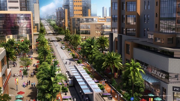
So I'm here to talk to you about the walkable city. What is the walkable city? Well, for want of a better definition, it's a city in which the car is an optional instrument of freedom, rather than a prosthetic device. And I'd like to talk about why we need the walkable city, and I'd like to talk about how to do the walkable city.
Sono qui per parlarvi delle città esplorabili. Cos'è una città esplorabile? Bene, per dare una definizione migliore, è una città in cui l'automobile è uno strumento opzionale di libertà, e non una protesi. Vorrei parlarvi del perché necessitiamo di città esplorabili e vorrei parlarvi di come rendere esplorabili le città.
Most of the talks I give these days are about why we need it, but you guys are smart. And also I gave that talk exactly a month ago, and you can see it at TED.com. So today I want to talk about how to do it. In a lot of time thinking about this, I've come up with what I call the general theory of walkability. A bit of a pretentious term, it's a little tongue-in-cheek, but it's something I've thought about for a long time, and I'd like to share what I think I've figured out.
Gran parte dei miei ultimi interventi riguardano il perché ne abbiamo bisogno, ma voi ragazzi siete intelligenti. Inoltre, l'ho spiegato in un intervento esattamente un mese fa, che potete vedere su TED.com. Oggi invece voglio parlarvi di come farlo. Dopo averci riflettuto a lungo, ho sviluppato la mia teoria generale dell'esplorabilità. Un termine forse pretenzioso, quasi uno scioglilingua, ma è qualcosa a cui ho dedicato lunghe riflessioni e mi piacerebbe condividere quello a cui sono arrivato.
In the American city, the typical American city -- the typical American city is not Washington, DC, or New York, or San Francisco; it's Grand Rapids or Cedar Rapids or Memphis -- in the typical American city in which most people own cars and the temptation is to drive them all the time, if you're going to get them to walk, then you have to offer a walk that's as good as a drive or better. What does that mean? It means you need to offer four things simultaneously: there needs to be a proper reason to walk, the walk has to be safe and feel safe, the walk has to be comfortable and the walk has to be interesting. You need to do all four of these things simultaneously, and that's the structure of my talk today, to take you through each of those.
Nella 'città americana', la città americana tipica -- la tipica città americana non è Washington DC, o New York, o San Francisco; è Grand Rapids o Cedar Rapids o Memphis -- nella tipica città americana quasi tutti possiedono un'auto e la tentazione è di guidarla sempre; se volete convincere la gente a camminare, bisogna offrire un percorso bello quanto un giro in auto, o meglio. Cosa significa? Bisogna offrire quattro elementi contemporaneamente: un buon motivo per camminare, un percorso sicuro che faccia sentire al sicuro, un cammino che sia confortevole e che sia interessante. Avete bisogno di tutti questi quattro elementi insieme, e questo è l'ordine del giorno, parlarvi di ognuno di essi.
The reason to walk is a story I learned from my mentors, Andrés Duany and Elizabeth Plater-Zyberk, the founders of the New Urbanism movement. And I should say half the slides and half of my talk today I learned from them. It's the story of planning, the story of the formation of the planning profession. When in the 19th century people were choking from the soot of the dark, satanic mills, the planners said, hey, let's move the housing away from the mills. And lifespans increased immediately, dramatically, and we like to say the planners have been trying to repeat that experience ever since.
La ragione per camminare è una storia appresa dai miei mentori, Andrés Duany ed Elizabeth Plater-Zyberk, i fondatori del Neourbanesimo. E vorrei dire che metà delle slide e metà del mio intervento di oggi l'ho imparato da loro. È la storia dell'urbanistica, la storia della formazione della professione di urbanista. Quando nel 1800 le persone soffocavano per i fumi delle mefistofeliche fabbriche, gli urbanisti dissero: "hey, allontaniamo le abitazioni dalle fabbriche". E l'aspettativa di vita aumentò immediatamente, drasticamente, e ci piace dire che gli urbanisti provano a ripetere quella esperienza da allora.
So there's the onset of what we call Euclidean zoning, the separation of the landscape into large areas of single use. And typically when I arrive in a city to do a plan, a plan like this already awaits me on the property that I'm looking at. And all a plan like this guarantees is that you will not have a walkable city, because nothing is located near anything else. The alternative, of course, is our most walkable city, and I like to say, you know, this is a Rothko, and this is a Seurat. It's just a different way -- he was the pointilist -- it's a different way of making places. And even this map of Manhattan is a bit misleading because the red color is uses that are mixed vertically.
Quindi questo è l'inizio della zonizzazione euclidea, la separazione del territorio in larghe zone ad uso singolo. E quando arrivo in una città per un progetto, un progetto simile mi aspetta già sulla proprietà che sto guardando. Un progetto come questo garantisce che la città non sarà esplorabile, perché tutti i luoghi sono lontani tra di loro. L'alternativa, naturalmente, è la nostra città più esplorabile, e, dovete sapere, mi piace dire che questo è un Rothko e questo è un Seaurat. È solo un modo differente -- lui era un puntinista --- è un modo diverso di creare luoghi. E anche questa mappa di Manhattan trae un po' in inganno perché il colore rosso indica utilizzi verticali misti.
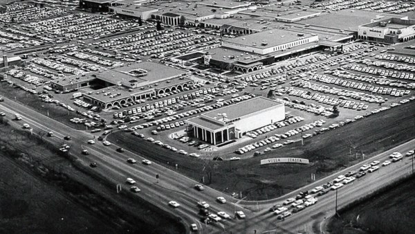
So this is the big story of the New Urbanists -- to acknowledge that there are only two ways that have been tested by the thousands to build communities, in the world and throughout history. One is the traditional neighborhood. You see here several neighborhoods of Newburyport, Massachusetts, which is defined as being compact and being diverse -- places to live, work, shop, recreate, get educated -- all within walking distance. And it's defined as being walkable. There are lots of small streets. Each one is comfortable to walk on. And we contrast that to the other way, an invention that happened after the Second World War, suburban sprawl, clearly not compact, clearly not diverse, and it's not walkable, because so few of the streets connect, that those streets that do connect become overburdened, and you wouldn't let your kid out on them. And I want to thank Alex Maclean, the aerial photographer, for many of these beautiful pictures that I'm showing you today.
Quindi questa è la grande storia del Nuovi Urbanisti -- riconoscere che ci sono soltanto due modi che sono stati collaudati da molti per costruire le comunità, nel mondo e nel corso della storia. Uno è il classico quartiere. Questi sono diversi quartieri di Newburyport, Massachusetts, che è definita dalla sua compattezza e dalla sua varietà -- posti dove vivere, lavorare, comprare, divertirsi, educarsi -- tutto raggiungibile a piedi. Ed è definita dalla sua esplorabilità. Ci sono moltissime stradine. Ognuna è adatta per camminarvi. E se facciamo il paragone con l'altro modo, un'invenzione che risale a dopo la Seconda Guerra Mondiale, la confusione suburbana, chiaramente non compatta, non diversificata e non esplorabile, perché ci sono poche strade collegate e quelle che fungono da collegamento sono sovraffollate, nessuno di voi ci manderebbe suo figlio. E voglio ringraziare Alex Maclean, esperto in foto aeree, per molte delle bellissime foto che vi sto mostrando oggi.
So it's fun to break sprawl down into its constituent parts. It's so easy to understand, the places where you only live, the places where you only work, the places where you only shop, and our super-sized public institutions. Schools get bigger and bigger, and therefore, further and further from each other. And the ratio of the size of the parking lot to the size of the school tells you all you need to know, which is that no child has ever walked to this school, no child will ever walk to this school. The seniors and juniors are driving the freshmen and the sophomores, and of course we have the crash statistics to prove it.
È divertente ridurre una massa scombinata nelle sue parti costitutive. È più facile da capire, il posto dove vivi soltanto, il posto dove lavori soltanto, i posti dove fai solo compere, e le nostre gigantesche istituzioni pubbliche. Le scuole sono sempre più grandi, e perciò, ancora più lontane l'una dall'altra. E la proporzione tra lo spazio dedicato al parcheggio e l'edificio scolastico ci dice già tutto, cioè che nessun bambino è mai andato a scuola a piedi e che nessuno ci andrà mai. Studenti del V e IV anno accompagnano in auto matricole e studenti del II, ce lo provano le statistiche sugli incidenti.
And then the super-sizing of our other civic institutions like playing fields -- it's wonderful that Westin in the Ft. Lauderdale area has eight soccer fields and eight baseball diamonds and 20 tennis courts, but look at the road that takes you to that location, and would you let your child bike on it? And this is why we have the soccer mom now. When I was young, I had one soccer field, one baseball diamond and one tennis court, but I could walk to it, because it was in my neighborhood.
E poi l'enormità delle nostre altre istituzioni civiche come i campi da gioco -- ed è fantastico che Westin nell'area di Fort Lauderdal abbia otto campi da calcio, otto campi da baseball e venti campi da tennis. Ma date un'occhiata alle strade che conducono a questi posti, lascereste andarci vostro figlio in bici? E infatti abbiamo le "mamme del calcio" ora. Quando ero giovane, c'era un campo da calcio, un campo da baseball e uno da tennis, ma ci andavo a piedi perché erano nel mio quartiere.
Then the final part of sprawl that everyone forgot to count: if you're going to separate everything from everything else and reconnect it only with automotive infrastructure, then this is what your landscape begins to look like. The main message here is: if you want to have a walkable city, you can't start with the sprawl model. you need the bones of an urban model. This is the outcome of that form of design, as is this. And this is something that a lot of Americans want. But we have to understand it's a two-part American dream. If you're dreaming for this, you're also going to be dreaming of this, often to absurd extremes, when we build our landscape to accommodate cars first. And the experience of being in these places --
E poi c'è l'ultimo elemento che tutti dimenticano: se si separa tutto da ogni cosa e lo si ricollega solo con le infrastrutture mobili, ecco come risulterà il paesaggio. Il messaggio è: una città esplorabile non può seguire questo modello tentacolare. Serve l'ossatura di un modello urbano. Questo è il risultato di quel tipo di progettazione, così come lo è questo E questo è qualcosa che moltissimi americani vogliono. Ma dobbiamo capire che è un sogno americano bipartito. Se stai sognando questo, sognerai anche di questo, spesso a un estremo assurdo, cioè quando costruiamo pensando prima alle auto. Vivere in questi posti--
(Laughter)
[il semaforo non diventa verde]
This is not Photoshopped. Walter Kulash took this slide. It's in Panama City. This is a real place. And being a driver can be a bit of a nuisance, and being a pedestrian can be a bit of a nuisance in these places. This is a slide that epidemiologists have been showing for some time now,
Non è stato usato Photoshop. Walter Kulash ha portato questa slide. È a Panama City. Questo è un posto reale. Guidare un'auto può essere un po' fastidioso, ed essere un pedone può essere un po' fastidioso in questi posti. Questa è una slide che gli epidemiologi mostrano da parecchio tempo ormai,
(Laughter)
(risate)
The fact that we have a society where you drive to the parking lot to take the escalator to the treadmill shows that we're doing something wrong. But we know how to do it better.
Il fatto che nella nostra società si guida fino al parcheggio e si fanno le scale mobili per fare il tapis roulant mostra che stiamo sbagliando. Ma sappiamo come rimediare.
Here are the two models contrasted. I show this slide, which has been a formative document of the New Urbanism now for almost 30 years, to show that sprawl and the traditional neighborhood contain the same things. It's just how big are they, how close are they to each other, how are they interspersed together and do you have a street network, rather than a cul-de-sac or a collector system of streets?
Ecco i due modelli contrapposti. E con questa slide, che è uno dei documenti costitutivi del Neourbanesimo da almeno 30 anni, vi mostro che il quartiere tradizionale e la massa confusa hanno le stesse cose. La differenza è la grandezza, la vicinanza tra i luoghi, come questi sono intervallati e se si ha una rete di strade piuttosto che un sistema a vicoli ciechi o a 'strade a imbuto'.
So when we look at a downtown area, at a place that has a hope of being walkable, and mostly that's our downtowns in America's cities and towns and villages, we look at them and say we want the proper balance of uses. So what is missing or underrepresented? And again, in the typical American cities in which most Americans live, it is housing that is lacking. The jobs-to-housing balance is off. And you find that when you bring housing back, these other things start to come back too, and housing is usually first among those things. And, of course, the thing that shows up last and eventually is the schools, because the people have to move in, the young pioneers have to move in, get older, have kids and fight, and then the schools get pretty good eventually.
Quando pensiamo al centro della città, a un luogo con una potenziale esplorabilità, e cioè al centro delle città, dei paesi e dei villaggi americani, vogliamo sempre un equilibrio tra i vari utilizzi. E quindi cosa manca o è sottorappresentato? Nelle tipiche città americane, in cui la maggior parte degli americani vive, ciò che manca sono le abitazioni. L'equilibrio casa-lavoro non esiste. Ma reintroducendo le abitazioni, anche altri elementi vengono reintrodotti. Le abitazioni quindi sono le prime a tornare in città e come ultimo elemento, ovviamente, abbiamo le scuole, perché le persone devono trasferirsi, i pionieri di domani devono trasferirsi, crescere, fare figli e litigare; e alla fine le scuole migliorano abbastanza.
The other part of this part, the useful city part, is transit, and you can have a perfectly walkable neighborhood without it. But perfectly walkable cities require transit, because if you don't have access to the whole city as a pedestrian, then you get a car, and if you get a car, the city begins to reshape itself around your needs, and the streets get wider and the parking lots get bigger and you no longer have a walkable city. So transit is essential. But every transit experience, every transit trip, begins or ends as a walk, and so we have to remember to build walkability around our transit stations.
L'altra parte di questa sezione, la sezione utile della città, riguarda il transito. Senza, si può avere benissimo un quartiere perfettamente esplorabile. Ma le città perfettamente esplorabili necessitano del transito, perché se i pedoni non hanno accesso all'intera città, allora comprano un'auto, e se comprano un'auto la città si riadatta ai bisogni che sono cambiati e le strade diventano più larghe, i parcheggi più grandi e la città non è più esplorabile. Il transito è cruciale. Ma ogni transito, ogni viaggio di transito, comincia o finisce a piedi. Quindi attorno alle stazioni di transito non si deve dimenticare l'esplorabilità.
Next category, the biggest one, is the safe walk. It's what most walkability experts talk about. It is essential, but alone not enough to get people to walk. And there are so many moving parts that add up to a walkable city.
La prossima categoria, la principale, è il percorso sicuro. Quasi ogni esperto di esplorabilità ne parla. È essenziale, ma non sufficiente da solo a far camminare la gente. Molti sono gli elementi mobili che formano una città esplorabile.
The first is block size. This is Portland, Oregon, famously 200-foot blocks, famously walkable. This is Salt Lake City, famously 600-foot blocks, famously unwalkable. If you look at the two, it's almost like two different planets, but these places were both built by humans and in fact, the story is that when you have a 200-foot block city, you can have a two-lane city, or a two-to-four lane city, and a 600-foot block city is a six-lane city, and that's a problem. These are the crash statistics. When you double the block size -- this was a study of 24 California cities -- when you double the block size, you almost quadruple the number of fatal accidents on non-highway streets.
Primo: le dimensioni degli isolati. Questa è Portland, Oregon, i famosi isolati di 60 metri, rinomatamente esplorabili. Questa è Salt Lake City, i famosi isolati di 180 metri, rinomatamente inesplorabili. Paragonando le due città, sembrano due pianeti diversi, ma l'uomo ha costruito entrambi questi luoghi. Anzi, se esiste una città con isolati di 60 metri, perché non una con strade a due corsie, o da due a quattro corsie, e una città con isolati da 180 metri ha strade a sei corsie, ecco il problema. Le statistiche sugli incidenti. Se gli isolati sono grandi il doppio -- ecco uno studio su 24 città californiane -- se gli isolati sono grandi il doppio il numero di incidenti mortali si quadruplica sulle strade interne, non le autostrade.
So how many lanes do we have? This is where I'm going to tell you what I tell every audience I meet, which is to remind you about induced demand. Induced demand applies both to highways and to city streets. And induced demand tells us that when we widen the streets to accept the congestion that we're anticipating, or the additional trips that we're anticipating in congested systems, it is principally that congestion that is constraining demand, and so that the widening comes, and there are all of these latent trips that are ready to happen. People move further from work and make other choices about when they commute, and those lanes fill up very quickly with traffic, so we widen the street again, and they fill up again. And we've learned that in congested systems, we cannot satisfy the automobile.
Quindi quante corsie ci sono? Ora vi dirò quello che dico sempre al mio pubblico, ovvero ricordatevi del traffico indotto. La teoria del traffico indotto si applica alle autostrade e alle strade urbane. Secondo la teoria allargando le strade per accettare il traffico che prevediamo ci sarà o i viaggi aggiuntivi che prevediamo avranno luogo nei sistemi congestionati, è principalmente la congestione stessa a limitare il traffico. Ed ecco allora un nuovo allargamento e nuovi viaggi latenti che stanno per avere luogo. Ci si sposta oltre il lavoro e si fanno altre scelte quando si viaggia; perciò il traffico riempie velocemente le corsie, allarghiamo di nuovo le strade e si riempiono ancora. Abbiamo imparato che nei sistemi congestionati non possiamo soddisfare le automobili.
This is from Newsweek Magazine -- hardly an esoteric publication: "Today's engineers acknowledge that building new roads usually makes traffic worse." My response to reading this was, may I please meet some of these engineers, because these are not the ones that I -- there are great exceptions that I'm working with now -- but these are not the engineers one typically meets working in a city, where they say, "Oh, that road is too crowded, we need to add a lane." So you add a lane, and the traffic comes, and they say, "See, I told you we needed that lane." This applies both to highways and to city streets if they're congested.
Dal Newsweek Magazine, una pubblicazione tutt'altro che astrusa: "Gli ingegneri moderni riconoscono che costruire nuove strade non fa che peggiorare il traffico". La mia reazione è stata: "fatemi conoscere questi ingegneri". Perché questi non sono gli ingegneri che-- ci sono grandi eccezioni con cui lavoro adesso-- non sono i tipici ingegneri che si incontrano lavorando in una città e che dicono: "quella strada è congestionata, serve un'altra corsia". Al che si aggiunge una corsia e c'è traffico e allora dicono: "visto, c'era bisogno della corsia". Questo vale per le autostrade e per le strade di città, se sono congestionate.
But the amazing thing about most American cities that I work in, the more typical cities, is that they have a lot of streets that are actually oversized for the congestion they're currently experiencing. This was the case in Oklahoma City, when the mayor came running to me, very upset, because they were named in Prevention Magazine the worst city for pedestrians in the entire country. Now that can't possibly be true, but it certainly is enough to make a mayor do something about it. We did a walkability study, and what we found, looking at the car counts on the street -- these are 3,000-, 4,000-, 7,000-car counts and we know that two lanes can handle 10,000 cars per day. Look at these numbers -- they're all near or under 10,000 cars, and these were the streets that were designated in the new downtown plan to be four lanes to six lanes wide. So you had a fundamental disconnect between the number of lanes and the number of cars that wanted to use them.
E la cosa sorprendente di molte città americane dove lavoro e di molte città tipiche è che hanno tante strade di dimensioni troppo grandi in relazione al volume di traffico presente. Un esempio è Oklahoma City, il cui sindaco si era rivolto a me, alquanto sconvolto perché era stata nominata nel Prevention Magazione come la città peggiore per i pedoni di tutto il Paese. Naturalmente è impossibile sia vero ma è certamente abbastanza per convincere un sindaco ad agire. Uno studio di esplorabilità ha dimostrato, contando le auto che ci sono per strada-- ovvero 3.000, 4.000, 7.000 automobili, che due corsie possono accomodare 10.000 automobili al giorno. Guardate questi numeri di auto -- sono tutti sotto o quasi a 10.000 e queste sono le strade previste dal nuovo piano urbano del centro, ovvero strade da 4 fino a 6 corsie. Non c'è alcuna coerenza tra il numero di corsie e il numero di auto che le percorrono.
So it was my job to redesign every street in the downtown from curb face to curb face, and we did it for 50 blocks of streets, and we're rebuilding it now. So a typical oversized street to nowhere is being narrowed, and now under construction, and the project is half done. The typical street like this, you know, when you do that, you find room for medians. You find room for bike lanes. We've doubled the amount of on-street parking. We've added a full bike network where one didn't exist before.
Il mio lavoro è stato quindi di riprogettare ogni strada del centro da cordolo a cordolo, l'abbiamo fatto per 50 isolati di strade e le stiamo ricostruendo. Una tipica strada enorme che non porta da nessuna parte è stata ristretta e ricostruita; il progetto è a metà strada. Una strada come questa, beh, se si trasforma così, si trova spazio per lo spartitraffico. Si trova spazio per le piste ciclabili. Abbiamo raddoppiato i parcheggi a bordo strada. Abbiamo creato una rete di piste ciclabili dove prima non c'era.
But not everyone has the money that Oklahoma City has, because they have an extraction economy that's doing quite well. The typical city is more like Cedar Rapids, where they have an all four-lane system, half one-way system. And it's a little hard to see, but what we've done -- what we're doing; it's in process right now, it's in engineering right now -- is turning an all four-lane system, half one-way into an all two-lane system, all two-way, and in so doing, we're adding 70 percent more on-street parking, which the merchants love, and it protects the sidewalk. That parking makes the sidewalk safe, and we're adding a much more robust bicycle network.
Ma non tutte le città hanno lo stesso budget di Oklahoma City, la cui economia basata sull'estrazione di petrolio è fiorente. La città tipica somiglia più a Cedar Rapids, dove hanno un sistema di strade a quattro corsie, metà delle quali a senso unico. Non è facile da capire, ma quello che abbiamo fatto -- che stiamo facendo ancora oggi, lo stiamo progettando -- è trasformare un sistema a quattro corsie con metà delle strade a senso unico in un sistema a due corsie con tutte le strade a doppio senso. Così si aggiunge il 70% di spazio per parcheggi a bordo strada, che fa felici i commercianti e protegge i marciapiedi. Ciò rende i marciapiedi più sicuri e stiamo anche aggiungendo una solida rete di piste ciclabili.
Then the lanes themselves. How wide are they? That's really important. The standards have changed such that, as Andrés Duany says, the typical road to a subdivision in America allows you to see the curvature of the Earth.
Ma per quanto riguarda le corsie, quanto sono larghe? È molto importante. Gli standard sono cambiati, a tal punto che, come dice Andrés Duany, nella tipica strada per un'area lottizzata si può vedere la curvatura della Terra.
(Laughter)
(risate)
This is a subdivision outside of Washington from the 1960s. Look very carefully at the width of the streets. This is a subdivision from the 1980s. 1960s, 1980s. The standards have changed to such a degree that my old neighborhood of South Beach, when it was time to fix the street that wasn't draining properly, they had to widen it and take away half our sidewalk, because the standards were wider. People go faster on wider streets. People know this. The engineers deny it, but the citizens know it, so that in Birmingham, Michigan, they fight for narrower streets. Portland, Oregon, famously walkable, instituted its "Skinny Streets" program in its residential neighborhood. We know that skinny streets are safer. The developer Vince Graham, in his project I'On, which we worked on in South Carolina, he goes to conferences and he shows his amazing 22-foot roads. These are two-way roads, very narrow rights of way, and he shows this well-known philosopher, who said, "Broad is the road that leads to destruction ... narrow is the road that leads to life."
Questa è un'area lottizzata fuori Washington degli anni '60. Fate attenzione alla larghezza delle strade. Questa è un'area lottizzata degli anni '80. Anni Sessanta, anni Ottanta. Gli standard sono cambiati talmente tanto che nel mio vecchio quartiere South Beach per la manutenzione di una strada a causa di problemi di drenaggio hanno dovuto allargarla ed eliminare metà marciapiede perché gli standard erano aumentati. Si guida più forte nelle strade larghe. Lo sanno tutti. Gli ingegneri lo negano, ma i cittadini lo sanno e infatti a Birmingham, Michigan, vogliono delle strade più strette. Portland, Oregon, rinomatamente esplorabile, ha messo in piedi il programma 'Skinny Streets' nel quartiere residenziale. Le strade strette sono più sicure. L'urbanista Vince Graham, grazie al suo progetto I'On sviluppato in Carolina del Sud, partecipa a molte conferenze in cui mostra le sue magnifiche strade larghe 7 metri. Sono strade a doppio senso, strette servitù di passaggio. E parla anche di questo noto filosofo che disse: "ampia è la strada che conduce alla distruzione... angusta è la strada che conduce alla vita".
(Laughter)
(risate)
(Applause)
(applausi)
This plays very well in the South.
È questo funziona sempre al Sud.
Now: bicycles. Bicycles and bicycling are the current revolution underway in only some American cities. But where you build it, they come. As a planner, I hate to say that, but the one thing I can say is that bicycle population is a function of bicycle infrastructure. I asked my friend Tom Brennan from Nelson\Nygaard in Portland to send me some pictures of the Portland bike commute. He sent me this. I said, "Was that bike to work day?" He said, "No, that was Tuesday." When you do what Portland did and spend money on bicycle infrastructure -- New York City has doubled the number of bikers in it several times now by painting these bright green lanes. Even automotive cities like Long Beach, California: vast uptick in the number of bikers based on the infrastructure. And of course, what really does it, if you know 15th Street here in Washington, DC -- please meet Rahm Emanuel's new bike lanes in Chicago, the buffered lane, the parallel parking pulled off the curb, the bikes between the parked cars and the curb -- these mint cyclists. If, however, as in Pasadena, every lane is a bike lane, then no lane is a bike lane. And this is the only bicyclist that I met in Pasadena, so ...
Allora, le biciclette. Le biciclette e lo spostarsi in bicicletta sono parte di una rivoluzione solo in alcune città americane. Se ci sono piste, ci sono ciclisti. Da urbanista mi dà fastidio dirlo, ma è certo che i ciclisti sono in funzione delle infrastrutture per biciclette. Ho chiesto al mio amico Tom Brennan della Nelson/Nygaard di Portland di inviarmi delle foto dei ciclisti a Portland. Visto ciò ho chiesto se fosse il giorno 'in bici a lavoro' ma no, era un martedì qualunque. Facendo ciò che è stato fatto a Portland, investire in infrastrutture ciclistiche-- a New York il numero di ciclisti è raddoppiato diverse volte ormai grazie a queste piste ciclabili verdi. Perfino nelle "città per automobili" come Long Beach, Californa c'è stato l'aumento del numero di ciclisti legato allo sviluppo delle infrastrutture. E ovvio, ciò che fa la differenza, se conoscete la 15th Street qui a Washington DC -- vi presento le nuove piste ciclabili di Rahm Emanuel a Chicago, la corsia protetta, le auto parcheggiate lontane dal cordolo e le bici che scorrono tra le auto parcheggiate e il cordolo -- ecco i ciclisti sani e salvi. Ma se, come a Pasadena, ogni corsia è una pista ciclabile, nessuna corsia lo è. E questo è l'unico ciclista che ho visto a Pasadena, quindi...
(Laughter)
(risate)
The parallel parking I mentioned -- it's an essential barrier of steel that protects the curb and pedestrians from moving vehicles. This is Ft. Lauderdale; one side of the street, you can park, the other side of the street, you can't. This is happy hour on the parking side. This is sad hour on the other side. And then the trees themselves slow cars down. They move slower when trees are next to the road, and, of course, sometimes they slow down very quickly. All the little details -- the curb return radius. Is it one foot or is it 40 feet? How swoopy is that curb to determine how fast the car goes and how much room you have to cross. And then I love this, because this is objective journalism. "Some say the entrance to CityCenter is not inviting to pedestrians." When every aspect of the landscape is swoopy, is aerodynamic, is stream-form geometrics, it says: "This is a vehicular place." So no one detail, no one speciality, can be allowed to set the stage. And here, you know, this street: yes, it will drain within a minute of the hundred-year storm, but this poor woman has to mount the curb every day.
Le auto parcheggiate come prima -- sono un'utile barriera di acciaio che protegge il cordolo e i pedoni dai veicoli in movimento. Questa è Ft. Lauderdale; da un lato della strada si può parcheggiare, dall'altro no. Ecco l'happy hour dal lato con parcheggio. Un po' meno 'happy' dall'altro lato. Inoltre anche gli alberi fanno rallentare le automobili Vanno infatti più piano se la via è alberata e , ovviamente, a volte rallentano molto velocemente. I piccoli dettagli -- il raggio di curvatura del cordolo. Deve essere di 30 cm o 12 m? La curvatura di quel cordolo determinerà la velocità assunta dalle auto e quanto spazio c'è per attraversare Adoro questo articolo, vero giornalismo obiettivo. "C'è chi dice che l'entrata del CityCenter non sia invitante per i pedoni". Quando ogni aspetto del paesaggio è curvo, aerodinamico e ha le geometrie di un ruscello, il messaggio è: "questo è un posto per veicoli". Nessun dettaglio, nessun campo da solo deve poter definire le regole del gioco. E qui, vedete, questa strada: certo, può assorbire in un minuto l'alluvione del secolo, ma questa povera signora deve scalare il cordolo ogni giorno.
So then quickly, the comfortable walk has to do with the fact that all animals seek, simultaneously, prospect and refuge. We want to be able to see our predators, but we also want to feel that our flanks are covered. And so we're drawn to places that have good edges, and if you don't supply the edges, people won't want to be there. What's the proper ratio of height to width? Is it one to one? Three to one? If you get beyond one to six, you're not very comfortable anymore. You don't feel enclosed. Now, six to one in Salzburg can be perfectly delightful. The opposite of Salzburg is Houston. The point being the parking lot is the principal problem here. However, missing teeth, those empty lots can be issues as well, and if you have a missing corner because of an outdated zoning code, then you could have a missing nose in your neighborhood. That's what we had in my neighborhood. This was the zoning code that said I couldn't build on that site. As you may know, Washington, DC is now changing its zoning to allow sites like this to become sites like this. We needed a lot of variances to do that. Triangular houses can be interesting to build, but if you get one built, people generally like it. So you've got to fill those missing noses.
In breve, un percorso confortevole fa riferimento al fatto che tutti gli animali cercano due cose: punto di vista e rifugio. Vogliamo poter vedere i nostri predatori e al contempo vogliamo sentirci al sicuro. Per questo siamo attratti dai luoghi con begli angoli e se i luoghi non hanno angoli le persone non vogliono andarci. Qual è il giusto rapporto altezza-larghezza? 1:1? 3:1? Se si va oltre l' 1:6 si perde in confort. Non ci si sente avvolti. Un 6:1 a Salisburgo può essere estremamente piacevole. Dall'altra parte della scala c'è Houston. Il punto è che il problema principale qui è il parcheggio. Ma, come denti mancanti, anche questi lotti vuoti possono porre un problema e se manca un angolo a causa di un codice di zonizzazione obsoleto allora può mancare anche il naso al quartiere in questione. È il caso del quartiere in cui vivevo. Qui il codice di zonizzazione per cui non si poteva costruire lì. Come saprete Washington DC sta emendando la propria zonizzazione per permettere a siti come questo di diventare così. Per cui c'era bisogno di diverse variazioni. Può essere una sfida costruire case triangolari ma alla gente di solito piace se ne si erige una. E quindi serve riempire i nasi mancanti.
And then, finally, the interesting walk: signs of humanity. We are among the social primates. Nothing interests us more than other people. We want signs of people. So the perfect one-to-one ratio, it's a great thing. This is Grand Rapids, a very walkable city, but nobody walks on this street that connects the two best hotels together, because if on the left, you have an exposed parking deck, and on the right, you have a conference facility that was apparently designed in admiration for that parking deck, then you don't attract that many people. Mayor Joe Riley, in his 10th term, Mayor of Charleston, South Carolina, taught us it only takes 25 feet of building to hide 250 feet of garage. This one I call the Chia Pet Garage. It's in South Beach. That active ground floor.
E infine il cammino interessante: segni di umanità. Siamo tra i primati sociali. Nulla ci interessa più delle altre persone. Vogliamo i segni delle persone. Quindi il rapporto 1:1, è un'ottima cosa. Questa è Grand Rapids, città molto esplorabile dove nessuno però cammina qui, nella strada che collega i due hotel migliori perché se sulla sinistra c'è un parcheggio multipiano a vista e sulla destra un centro per conferenze che sembra essere stato progettato a immagine del parcheggio di fronte allora alla gente non verrà voglia di camminarci. Joe Riley, sindaco di Charleston, Carolina del Sud, al suo 10° mandato, insegna che servono solo 7,5 m di palazzi per nascondere un parcheggio di 76 m. Questo a South Beach lo chiamo "parcheggio vaso di terracotta". E il piano terra è attivo.
I want to end with this project that I love to show. It's by Meleca Architects. It's in Columbus, Ohio. To the left is the convention center neighborhood, full of pedestrians. To the right is the Short North neighborhood -- ethnic, great restaurants, great shops, struggling. It wasn't doing very well because this was the bridge, and no one was walking from the convention center into that neighborhood. Well, when they rebuilt the highway, they added an extra 80 feet to the bridge. Sorry -- they rebuilt the bridge over the highway. The city paid 1.9 million dollars, they gave the site to a developer, the developer built this and now the Short North has come back to life. And everyone says, the newspapers, not the planning magazines, the newspapers say it's because of that bridge.
Concludo con questo progetto che mi piace mostrare. È della Meleca Architects, si trova a Columbus, Ohio. A sinistra il quartiere del centro congressi, pieno di pedoni. A destra il quartiere di Short North -- diverse etnie, ottimi ristoranti, bei negozi, in crisi. Le cose non andavano bene perché questo era il ponte e nessuno andava dal quartiere del centro congressi a questo quartiere a piedi. Quando hanno ricostruito l'autostrada hanno allargato di 25 m il ponte. O meglio, hanno ricostruito il ponte sull'autostrada. La città ha pagato 1,9 milioni di dollari, ha affidato il sito a un urbanista; l'urbanista ha fatto questo e il Short North è tornato a nuova vita. E a detta di tutti - i giornali, non le riviste di urbanistica - i giornali affermano che è merito del ponte.
So that's it. That's the general theory of walkability. Think about your own cities. Think about how you can apply it. You've got to do all four things at once. So find those places where you have most of them and fix what you can, fix what still needs fixing in those places.
È tutto. La teoria generale delle città esplorabili. Pensate alle vostre città. A come vi si possa applicare. Con i quattro elementi tutti insieme. Trovate i luoghi dove ve ne sono di più e migliorate ciò che potete, migliorate ciò che deve essere migliorato in quei luoghi.
I really appreciate your attention, and thank you for coming today.
Grazie per la vostra attenzione e grazie per essere venuti qui oggi.
(Applause)
(Applausi)