Technology can change our understanding of nature.
Teknoloji doğa anlayışımızı değiştirebilir.
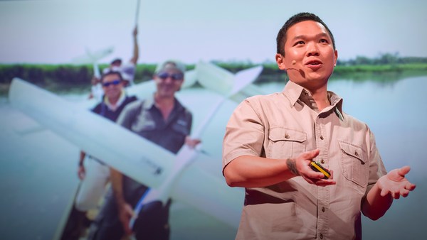
Take for example the case of lions. For centuries, it's been said that female lions do all of the hunting out in the open savanna, and male lions do nothing until it's time for dinner. You've heard this too, I can tell. Well recently, I led an airborne mapping campaign in the Kruger National Park in South Africa. Our colleagues put GPS tracking collars on male and female lions, and we mapped their hunting behavior from the air. The lower left shows a lion sizing up a herd of impala for a kill, and the right shows what I call the lion viewshed. That's how far the lion can see in all directions until his or her view is obstructed by vegetation. And what we found is that male lions are not the lazy hunters we thought them to be. They just use a different strategy. Whereas the female lions hunt out in the open savanna over long distances, usually during the day, male lions use an ambush strategy in dense vegetation, and often at night. This video shows the actual hunting viewsheds of male lions on the left and females on the right. Red and darker colors show more dense vegetation, and the white are wide open spaces. And this is the viewshed right literally at the eye level of hunting male and female lions. All of a sudden, you get a very clear understanding of the very spooky conditions under which male lions do their hunting.
Örnek olarak aslanları alalım. Yüzyıllardır, açık ovalardaki bütün avlanma işini dişi aslanların yaptığı, erkek aslanların ise hazır yemeğe kondukları söylenir. Siz de kesin duymuşsunuzdur, tahminimce. Kısa bir süre önce, Güney Afrika'daki Kruger Ulusal Parkı'nda havadan haritalama çalışmasının başında bulundum. Meslektaşlarımız, erkek ve dişi aslanlara GPS (küresel konumlandırma sistemi) takip tasması taktılar ve onların avlanma davranışlarını havadan haritaladık. Sol altta, bir aslanın av için bir antilop sürüsünü süzüşünü gösteriyor ve sağda gördüğünüze ise, aslanın görüş açıklığı adını verdim. Bitki örtüsü tarafından engellenmediği sürece aslanın tüm yönlerde görebileceği uzaklık bu kadardır. Ve gördük ki, erkek aslanlar düşündüğümüz gibi tembel avcılar değillermiş. Sadece farklı bir yöntem kullanıyorlarmış. Dişi aslanlar açık ovada, genellikle de gün boyunca uzun mesafelerde avlanırken, erkek aslanlar ise yoğun bitki örtüsünde, daha çok geceleyin pusu yöntemi kullanıyorlar. Bu video gerçek avlanmada görüş açıklığını gösteriyor. Soldaki erkeğin, ve sağdaki ise dişinin. Kırmızı ve koyu renkler daha yoğun bitki örtüsünü ve beyaz ise açık alanları gösteriyor. Ve bu da, avlanan erkek ve dişi aslanların göz seviyesinden görüş açıklığını gösteriyor. Birden, erkek aslanların avlandıkları ürkütücü koşulları net olarak anlıyorsunuz.
I bring up this example to begin, because it emphasizes how little we know about nature. There's been a huge amount of work done so far to try to slow down our losses of tropical forests, and we are losing our forests at a rapid rate, as shown in red on the slide. I find it ironic that we're doing so much, yet these areas are fairly unknown to science. So how can we save what we don't understand?
Bu örnekle başladım, çünkü bu doğa hakkında ne kadar az şey bildiğimizi gösteriyor. Şimdiye kadar, tropik orman kayıplarını yavaşlatmak için çok büyük işler yapıldı ve yansıda kırmızı ile gösterildiği gibi ormanlarımızı hızla kaybediyoruz. O kadar ironik ki, o kadar şey yapıyoruz, ama bu alanlar bilim için tam bir bilinmez. Peki anlamadığımız şeyi nasıl kurtarabiliriz?
Now I'm a global ecologist and an Earth explorer with a background in physics and chemistry and biology and a lot of other boring subjects, but above all, I'm obsessed with what we don't know about our planet. So I created this, the Carnegie Airborne Observatory, or CAO. It may look like a plane with a fancy paint job, but I packed it with over 1,000 kilos of high-tech sensors, computers, and a very motivated staff of Earth scientists and pilots. Two of our instruments are very unique: one is called an imaging spectrometer that can actually measure the chemical composition of plants as we fly over them. Another one is a set of lasers, very high-powered lasers, that fire out of the bottom of the plane, sweeping across the ecosystem and measuring it at nearly 500,000 times per second in high-resolution 3D. Here's an image of the Golden Gate Bridge in San Francisco, not far from where I live. Although we flew straight over this bridge, we imaged it in 3D, captured its color in just a few seconds. But the real power of the CAO is its ability to capture the actual building blocks of ecosystems. This is a small town in the Amazon, imaged with the CAO. We can slice through our data and see, for example, the 3D structure of the vegetation and the buildings, or we can use the chemical information to actually figure out how fast the plants are growing as we fly over them. The hottest pinks are the fastest-growing plants. And we can see biodiversity in ways that you never could have imagined. This is what a rainforest might look like as you fly over it in a hot air balloon. This is how we see a rainforest, in kaleidoscopic color that tells us that there are many species living with one another. But you have to remember that these trees are literally bigger than whales, and what that means is that they're impossible to understand just by walking on the ground below them. So our imagery is 3D, it's chemical, it's biological, and this tells us not only the species that are living in the canopy, but it tells us a lot of information about the rest of the species that occupy the rainforest.
Ben, özgeçmişinde fizik, kimya, biyoloji ve başka bir sürü sıkıcı konu olan bir küresel çevrebilimci ve yerküre araştırmacısıyım, ama hepsi bir yana, ben gezegenimiz hakkında bilmediklerimize kafayı takmış durumdayım. O nedenle bunu yarattım: Carnegie Hava Gözlemevi, veya CHG. Güzelce boyanmış bir uçak gibi gözükebilir, ama onun içine 1000 kilodan fazla gelen, yüksek teknoloji sensörler, bilgisayarlar ve yerküre bilimcileri ve pilotlardan oluşan çok istekli bir kadro koydum. Aletlerimizden ikisi oldukça eşsiz: Birisi görüntüleme spektrometresi. Bitkilerin üzerinden uçarken onların kimyasal bileşimini ölçüyor. Diğeri ise lazer seti. Uçağın altından çıkan çok güçlü lazerler, 3B yüksek çözünürlükte ekosistemi tarıyor ve neredeyse saniyede 500.000 kez ölçüyor. Burada, yaşadığım yerden pek uzak olmayan San Francisco'daki Golden Gate Köprüsü'nün bir resmi var. Köprünün direkt üzerinden uçmamıza rağmen, saniyeler içerisinde onu 3B olarak görüntüledik, rengini yakaladık. Ama CHG'nin asıl gücü, ekosistemin asıl yapı taşlarını yakalayabilme yeteneğidir. Burası, CHG ile görüntülenen Amazon'daki küçük bir kasaba. Verilerimizi dilimleyebilir ve örneğin, bitki örtüsü ve binaların 3B yapısını görebilir veya kimyasal bilgiyi kullanarak bitkilerin ne hızla büyüdüklerini üzerilerinden uçarken hesaplayabiliriz. Sıcak pembeler en hızlı büyüyen bitkiler. Ve biyo-çeşitliliği hayal edemeyeceğiniz yollardan görebiliriz. Bir yağmur ormanı, üzerinden sıcak hava balonuyla uçarken böyle görünüyor. Biz ise bir yağmur ormanını böyle görüyoruz, kaleydoskopik renkler bizlere birbiriyle yaşayan birçok tür olduğunu söylüyor. Ama unutmayın ki, bu ağaçlar gerçekte balinalardan daha büyüktür ve bu da demektir ki, bunları yerde yanlarından geçerken anlamak imkânsızdır. Görüntülerimiz 3 boyutludur, kimyasaldır, biyolojiktir ve bu bize sadece kanopide yaşayan türleri değil, aynı zamanda yağmur ormanlarında bulunan diğer türler hakkında da birçok bilgi verir.
Now I created the CAO in order to answer questions that have proven extremely challenging to answer from any other vantage point, such as from the ground, or from satellite sensors. I want to share three of those questions with you today. The first questions is, how do we manage our carbon reserves in tropical forests? Tropical forests contain a huge amount of carbon in the trees, and we need to keep that carbon in those forests if we're going to avoid any further global warming. Unfortunately, global carbon emissions from deforestation now equals the global transportation sector. That's all ships, airplanes, trains and automobiles combined. So it's understandable that policy negotiators have been working hard to reduce deforestation, but they're doing it on landscapes that are hardly known to science. If you don't know where the carbon is exactly, in detail, how can you know what you're losing? Basically, we need a high-tech accounting system. With our system, we're able to see the carbon stocks of tropical forests in utter detail. The red shows, obviously, closed-canopy tropical forest, and then you see the cookie cutting, or the cutting of the forest in yellows and greens. It's like cutting a cake except this cake is about whale deep. And yet, we can zoom in and see the forest and the trees at the same time. And what's amazing is, even though we flew very high above this forest, later on in analysis, we can go in and actually experience the treetrops, leaf by leaf, branch by branch, just as the other species that live in this forest experience it along with the trees themselves.
İşte CHG'yi, yer veya uydu sensörleri gibi noktalar yardımıyla cevaplanması son derece zor soruları cevaplamak için yarattım. Bugün sizinle bu soruların üç tanesini paylaşmak istiyorum. İlk soru, tropik ormanlardaki karbon rezervlerimizi nasıl yönetiyoruz? Tropik ormanlardaki ağaçlarda büyük miktarda karbon bulunur ve daha fazla küresel ısınmanın önüne geçmek için bu karbonları bu ormanlarda tutmamız gerekir. Ne yazık ki, ağaçların yok olması nedeniyle ortaya çıkan küresel karbon salınımları küresel ulaşım sektörüyle yarışır hale geldi. Buna tüm gemiler, uçaklar, trenler ve otomobiller dâhil. Siyasilerin ağaçların yok olmasını azaltmak için sıkı çalışmaları anlaşılabilir bir şey, ama bu işi, bilimin pek bilmediği arazilerde yapıyorlar. Eğer karbonun tam olarak nerede olduğunu detaylı olarak bilmiyorsanız, ne kaybettiğinizi nasıl bilebilirsiniz? Esasında, ihtiyacımız olan şey yüksek teknolojili sayma sistemi. Sistemimizle, tropik ormanlardaki karbon stoklarını ayrıntılı olarak görebiliyoruz. Kırmızı, anlaşıldığı gibi, kapalı tropik ormanı gösteriyor ve sonrasında kalıp şeklinde kesilmiş ormanları sarı ve yeşiller olarak görüyorsunuz. Bu tıpkı bir keki kesmek gibi, fakat bu kek bir balina derinliğinde. Ve ayrıca, yaklaşarak ormanı ve ağaçları aynı anda görebiliyoruz. Ve şaşırtıcı olan ise, ormanın çok üstünden uçmamıza rağmen, daha sonra analiz yaparken ormanda yaşayan ve bunu ağaçlarla birlikte deneyimleyen diğer türler gibi, yapraklarına ve dallarına kadar ağaçların tepesinde gezip deneyimleyebiliyoruz.
We've been using the technology to explore and to actually put out the first carbon geographies in high resolution in faraway places like the Amazon Basin and not-so-faraway places like the United States and Central America. What I'm going to do is I'm going to take you on a high-resolution, first-time tour of the carbon landscapes of Peru and then Panama. The colors are going to be going from red to blue. Red is extremely high carbon stocks, your largest cathedral forests you can imagine, and blue are very low carbon stocks. And let me tell you, Peru alone is an amazing place, totally unknown in terms of its carbon geography until today. We can fly to this area in northern Peru and see super high carbon stocks in red, and the Amazon River and floodplain cutting right through it. We can go to an area of utter devastation caused by deforestation in blue, and the virus of deforestation spreading out in orange. We can also fly to the southern Andes to see the tree line and see exactly how the carbon geography ends as we go up into the mountain system. And we can go to the biggest swamp in the western Amazon. It's a watery dreamworld akin to Jim Cameron's "Avatar." We can go to one of the smallest tropical countries, Panama, and see also a huge range of carbon variation, from high in red to low in blue. Unfortunately, most of the carbon is lost in the lowlands, but what you see that's left, in terms of high carbon stocks in greens and reds, is the stuff that's up in the mountains. One interesting exception to this is right in the middle of your screen. You're seeing the buffer zone around the Panama Canal. That's in the reds and yellows. The canal authorities are using force to protect their watershed and global commerce. This kind of carbon mapping has transformed conservation and resource policy development. It's really advancing our ability to save forests and to curb climate change.
Bu teknolojiyi, Amazon gibi uzak ve Birleşik Devletler ve Orta Amerika gibi çok uzak olmayan yerleri keşfetmek ve ilk karbon coğrafyalarını yüksek çözünürlükte çıkarmak için kullanıyoruz. Şimdi ise sizi, yüksek çözünürlükte, ilk defa Peru ve sonra Panama'nın karbon arazilerinde gezdireceğim. Renkler, kırmızı ve mavi aralığında olacak. Kırmızı, hayal edebileceğiniz en büyük ormanlardaki yüksek karbon stoğunu gösterir. Ve mavi ise çok düşük karbon stoklarıdır. Söylemeliyim ki, Peru harika bir yer, karbon coğrafyası açısından hiç bilinmeyen bir yer, tabii ki bugüne kadar. Kuzey Peru'daki bu alana uçabilir ve kırmızı renkle gösterilen yüksek karbon stoklarını ve onu kesen Amazon Nehri'ni ve taşkın yatağını görebiliriz. Ormansızlaşma nedeniyle tamamen harap olmuş maviyle gösterilen alana ve turuncu renkteki yayılan ormansızlaşma virüsünü görebiliriz. Ağaç sınırını görmek için güney And dağlarına uçabilir ve dağ sisteminde yükselirken karbon coğrafyasının nasıl bittiğini görebiliriz. Ve batı Amazon'daki en büyük bataklığa gidebiliriz. Burası sulu bir masal âlemi. Jim Cameron'un "Avatar"ına benziyor. En küçük tropikal ülkelerden birisi olan Panama'ya gidebiliriz ve büyük karbon çeşitliliği yelpazesini görebiliriz, kırmızı olan yüksek değerlerden, mavi olan düşük değerlere kadar. Ne yazık ki, en çok karbon kaybı ovalarda oluyor. Gördüğünüz kalan yüksek karbon stokları ise yeşil ve kırmızı renklerle gösterilen dağlardaki alanlardır. Buna ilginç bir istisna ise, ekranın tam ortasında. Panama Kanalı etrafındaki tampon bölgeyi görüyorsunuz. Kırmızı ve sarılarla gösteriliyor. Kanal yetkilileri havzalarını ve küresel ticareti korumak için güç kullanıyor. Bu tür bir karbon haritalama, koruma ve kaynak politikası gelişimini değiştirdi. Bu, ormanları kurtarma ve iklim değişikliğini durdurma yeteneğimizi gerçekten geliştiriyor.
My second question: How do we prepare for climate change in a place like the Amazon rainforest? Let me tell you, I spend a lot of time in these places, and we're seeing the climate changing already. Temperatures are increasing, and what's really happening is we're getting a lot of droughts, recurring droughts. The 2010 mega-drought is shown here with red showing an area about the size of Western Europe. The Amazon was so dry in 2010 that even the main stem of the Amazon river itself dried up partially, as you see in the photo in the lower portion of the slide. What we found is that in very remote areas, these droughts are having a big negative impact on tropical forests. For example, these are all of the dead trees in red that suffered mortality following the 2010 drought. This area happens to be on the border of Peru and Brazil, totally unexplored, almost totally unknown scientifically.
İkinci sorum: İklim değişikliğine Amazon yağmur ormanları gibi bir yerde nasıl hazırlanırız? Şunu söyleyebilirim ki, bu yerlerde çok vakit geçiriyorum ve iklimin çoktan değiştiğini görüyoruz. Sıcaklıklar artıyor ve çok fazla kuraklıkla karşılaşıyoruz, tekrarlanan kuraklıklar. 2010 yılı büyük kuraklığı burada görülüyor. Kırmızı yer, Batı Avrupa büyüklüğünde bir alan. 2010 yılında Amazon o kadar kuruydu ki, Amazon Nehri'nin ana kolu bile, yansının alt köşesindeki resimde gördüğünüz gibi, kısmi olarak kurudu. Çok uzak alanlarda bu kuraklıkların tropik ormanlara çok olumsuz etki ettiğini gördük. Örneğin, 2010'daki kuraklık sonrası ölen ağaçlar kırmızı ile gösterilmiştir. Bu alan, Peru ve Brezilya sınırında, hiç keşfedilmemiş, bilimsel olarak neredeyse hiç bilinmiyor.
So what we think, as Earth scientists, is species are going to have to migrate with climate change from the east in Brazil all the way west into the Andes and up into the mountains in order to minimize their exposure to climate change. One of the problems with this is that humans are taking apart the western Amazon as we speak. Look at this 100-square-kilometer gash in the forest created by gold miners. You see the forest in green in 3D, and you see the effects of gold mining down below the soil surface. Species have nowhere to migrate in a system like this, obviously.
Yerküre bilimcileri olarak düşündüğümüz şey, türler, iklim değişikliği ile birlikte iklim değişikliğinden en az etkilenmek için doğu Brezilya'dan, batıya doğru And Dağları'nın tepelerine göç etmek zorunda kalacaklar. Buradaki problemlerden birisi de, insanların biz burada konuşurken, batı Amazon'u bütünlüğünü bozuyor olmasıdır. Ormanda altın madencilerinin yaptıkları 100 kilometrekarelik yarığa bakın. Ormanı yeşil renkte 3B olarak görüyorsunuz ve toprak yüzeyinin altında yapılan altın madenciliğinin etkilerini görüyorsunuz. Böyle bir sistemde, görüldüğü üzere, türlerin göç edebileceği bir yer yok.
If you haven't been to the Amazon, you should go. It's an amazing experience every time, no matter where you go. You're going to probably see it this way, on a river. But what happens is a lot of times the rivers hide what's really going on back in the forest itself. We flew over this same river, imaged the system in 3D. The forest is on the left. And then we can digitally remove the forest and see what's going on below the canopy. And in this case, we found gold mining activity, all of it illegal, set back away from the river's edge, as you'll see in those strange pockmarks coming up on your screen on the right. Don't worry, we're working with the authorities to deal with this and many, many other problems in the region.
Eğer Amazon'a gitmediyseniz, gitmelisiniz. Her seferinde müthiş bir deneyim, neresine giderseniz gidin. Nehir üzerinden göreceğiniz manzara muhtemelen şöyle. Ama nehirler çoğu zaman ormanda aslında neler olduğunu saklıyor. Aynı nehrin üzerinden uçarak, sistemi 3B olarak görüntüledik. Orman solda. Ve sonra, ormanı dijital olarak kaldırabiliyor ve kanopi altında neler olduğunu görebiliyoruz. Ve bu örnekte, sağdaki ekranda garip bozulmaları gördüğünüz gibi, nehir kenarından uzağa kurulmuş tamamı yasa dışı olan, altın madenciliği faaliyeti bulduk. Merak etmeyin, bölgedeki bu ve bunun gibi birçok problemle baş etmek için yetkililerle beraber çalışıyoruz.
So in order to put together a conservation plan for these unique, important corridors like the western Amazon and the Andes Amazon corridor, we have to start making geographically explicit plans now. How do we do that if we don't know the geography of biodiversity in the region, if it's so unknown to science? So what we've been doing is using the laser-guided spectroscopy from the CAO to map for the first time the biodiversity of the Amazon rainforest. Here you see actual data showing different species in different colors. Reds are one type of species, blues are another, and greens are yet another. And when we take this together and scale up to the regional level, we get a completely new geography of biodiversity unknown prior to this work. This tells us where the big biodiversity changes occur from habitat to habitat, and that's really important because it tells us a lot about where species may migrate to and migrate from as the climate shifts. And this is the pivotal information that's needed by decision makers to develop protected areas in the context of their regional development plans.
Batı Amazon ve And Amazon koridoru gibi bu eşsiz, önemli geçitlere yönelik bir koruma planı oluşturmak için, coğrafi olarak detaylı planlar yapmaya hemen başlamalıyız. Eğer bölgedeki biyo-çeşitlilik coğrafyasını bilmiyorsak ve bu bilime tamamen yabancı ise bunu nasıl yapacağız? Bu sebeple, yaptığımız şey, CHG'deki lazer güdümlü spektroskopiyi Amazon yağmur ormanı biyo-çeşitliğini ilk defa haritalamak için kullanmak. Burada farklı türleri, farklı renklerde gösteren gerçek veriyi görüyorsunuz. Kırmızılar bir tür, maviler başka bir tür, ve yeşiller de yine başka bir tür. Bunları biraraya getirip, bölgesel düzeye kadar büyüttüğümüzde, bu çalışma öncesinde bilinmeyen, tamamen yeni bir biyo-çeşitlilik coğrafyası elde ediyoruz. Bu bize, büyük biyo-çeşitlilik değişimlerinin nerede meydana geldiğini habitat habitat gösteriyor ve bu çok önemli, çünkü bize iklim değiştikçe türlerin nereye göç edebileceği ve nereden göç edebilecekleri hakkında birçok bilgi sağlıyor. Ve bu da, karar vericilerin, bölgesel gelişim planları çerçevesinde koruma alanları geliştirmeleri için çok önemli bir bilgidir.
And third and final question is, how do we manage biodiversity on a planet of protected ecosystems? The example I started out with about lions hunting, that was a study we did behind the fence line of a protected area in South Africa. And the truth is, much of Africa's nature is going to persist into the future in protected areas like I show in blue on the screen. This puts incredible pressure and responsibility on park management. They need to do and make decisions that will benefit all of the species that they're protecting. Some of their decisions have really big impacts. For example, how much and where to use fire as a management tool? Or, how to deal with a large species like elephants, which may, if their populations get too large, have a negative impact on the ecosystem and on other species. And let me tell you, these types of dynamics really play out on the landscape. In the foreground is an area with lots of fire and lots of elephants: wide open savanna in blue, and just a few trees. As we cross this fence line, now we're getting into an area that has had protection from fire and zero elephants: dense vegetation, a radically different ecosystem. And in a place like Kruger, the soaring elephant densities are a real problem. I know it's a sensitive issue for many of you, and there are no easy answers with this. But what's good is that the technology we've developed and we're working with in South Africa, for example, is allowing us to map every single tree in the savanna, and then through repeat flights we're able to see which trees are being pushed over by elephants, in the red as you see on the screen, and how much that's happening in different types of landscapes in the savanna. That's giving park managers a very first opportunity to use tactical management strategies that are more nuanced and don't lead to those extremes that I just showed you. So really, the way we're looking at protected areas nowadays is to think of it as tending to a circle of life, where we have fire management, elephant management, those impacts on the structure of the ecosystem, and then those impacts affecting everything from insects up to apex predators like lions.
Üçüncü ve son soru ise: Korunan ekosistemli bir gezegende biyo-çeşitliliği nasıl yönetiriz? İlk baştaki aslanların avlanması örneği, Güney Afrika'da bir koruma alanında tellerin arkasında yaptığımız bir çalışmaydı. İşin aslı, Afrika doğasının çoğunluğu gelecekte, ekrandaki mavilerde gösterdiğim koruma alanlarında varlığını sürdürecek. Bu, park yönetimine inanılmaz bir baskı ve sorumluluk yüklüyor. Korudukları tüm türlere fayda sağlayacak şeyleri yapmaları ve kararları vermeleri gerekiyor. Bazı kararlarının çok büyük etkisi oluyor. Mesela, yangını ne kadar ve nerede bir yönetim aracı olarak kullanmalı? Veya, filler gibi nüfusları çok artması durumunda ekosisteme ve diğer türlere zarar verecek olan büyük türlerle nasıl baş edilir? Ve şunu da söyleyeyim ki, bu tür dinamikler tabiat içerisinde gerçekten tükeniyor. Ön taraf, yangınla dolu bir alan ve bir sürü fil var: Mavi renkte geniş açık ova ve birkaç ağaç var. Bu çitleri geçince, yangından korunan ve hiç fil olmayan bir alana giriyoruz: Sıkı bitki örtüsü, tamamıyla farklı bir ekosistem. Ve Kruger gibi bir yerde, hızla artan fil yoğunluğu gerçek bir problem. Birçoğunuz için bunun hassas bir konu olduğunu biliyorum ve bunlara cevap vermek de kolay değil. Ama güzel olan tarafı, geliştirdiğimiz ve örneğin Güney Afrika'da kullandığımız teknoloji, bizlere ovadaki her bir ağacı haritalamamızı sağlıyor, ve tekrar uçuşlarla hangi ağaçların filler tarafından itildiğini ekrandaki kırmızılarda görebiliyoruz ve bunun savanadaki farklı arazilerde ne kadar meydana geldiğini de. Bu, park yöneticilerine, daha incelikli ve az önce size gösterdiğim aşırılıklara yola açmayan taktik yönetim stratejilerini kullanmak için yeni bir fırsat veriyor. Yani aslında, korunmuş alanlara bugün baktığımızda onları, yaşam döngüsüne doğru bir eğilim olarak düşünüyoruz. Yangın yönetimine, fil yönetimine sahip olduğumuz, bunların ekosistemin yapısı üzerinde etki ettiği ve sonra böceklerden aslanlar gibi tepe yırtıcılara kadar her şeye etki ettiği bir yer.
Going forward, I plan to greatly expand the airborne observatory. I'm hoping to actually put the technology into orbit so we can manage the entire planet with technologies like this. Until then, you're going to find me flying in some remote place that you've never heard of. I just want to end by saying that technology is absolutely critical to managing our planet, but even more important is the understanding and wisdom to apply it.
İleride, hava gözlemevini oldukça büyütmeyi planlıyorum. Bu teknolojiyi yörüngeye oturtmayı umuyorum ki, böylece tüm gezegeni bu gibi teknolojilerle yönetebilelim. O zamana kadar, beni adını hiç duymadığınız uzak bir diyarda uçarken bulacaksınız. Sözlerimi, teknolojinin gezegenimizi yönetme noktasında son derece önemli olduğunu söyleyerek bitirmek istiyorum. Ama daha da önemlisi, onu anlamak ve onu uygulayacak dirayete sahip olmak.
Thank you.
Teşekkür ederim.
(Applause)
(Alkış)