Technology can change our understanding of nature.
Technológia môže zmeniť naše vnímanie prírody.
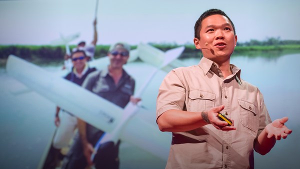
Take for example the case of lions. For centuries, it's been said that female lions do all of the hunting out in the open savanna, and male lions do nothing until it's time for dinner. You've heard this too, I can tell. Well recently, I led an airborne mapping campaign in the Kruger National Park in South Africa. Our colleagues put GPS tracking collars on male and female lions, and we mapped their hunting behavior from the air. The lower left shows a lion sizing up a herd of impala for a kill, and the right shows what I call the lion viewshed. That's how far the lion can see in all directions until his or her view is obstructed by vegetation. And what we found is that male lions are not the lazy hunters we thought them to be. They just use a different strategy. Whereas the female lions hunt out in the open savanna over long distances, usually during the day, male lions use an ambush strategy in dense vegetation, and often at night. This video shows the actual hunting viewsheds of male lions on the left and females on the right. Red and darker colors show more dense vegetation, and the white are wide open spaces. And this is the viewshed right literally at the eye level of hunting male and female lions. All of a sudden, you get a very clear understanding of the very spooky conditions under which male lions do their hunting.
Vezmite si napríklad takých levov. Po stáročia sa verilo že levie samice majú na starosti celý lov v priestrannej savane, a že levie samce nerobia nič až pokiaľ je čas na večeru. Vy ste to tiež počuli, som si istý. Nuž, nedávno, som viedol vzdušnú mapujúcu kampaň v Kruger National Park v Južnej Afrike. Naši kolegovia umiestnili GPS do mapujúcich obojkov na levích samcov a samice, a mapovali sme ich správanie v oblasti lovenia zo vzduchu. Dole naľavo je ukázaný lev, ktorý blokuje stádo antilop na lovenie, a napravo vidíte čo ja volám leví pozorovací úkryt. To je miesto, z ktorého lev môže vidieť do všetkých smerov pokiaľ jeho alebo jej výhľad nie je prekazený vegetáciou. A čo sme zistili je že leví samci nie sú leniví lovci ako sme si pôvodne mysleli. Oni len používajú inú stratégiu. Zatiaľ čo levie samice lovia na rozľahlej otvorenej savane na veľké vzdialenosti, zvyčajne počas dňa, leví samci používajú stratégiu náhleho prekvapenia v hustej vegetácií, a častokrát v noci. Toto video ukazuje skutočné pozorovacie úkryty, používané na lov levími samcami, naľavo a samíc napravo. Cervené a tmavšie farby ukazujú hustejšiu vegetáciu, a biele sú široké otvorené priestranstvá. A toto je pozorovací úkryt hned v úrovni očí loviaceho samca a samice leva. Zrazu, jasne pochopíte veľmi strašidelné podmienky za ktorých leví samci lovia.
I bring up this example to begin, because it emphasizes how little we know about nature. There's been a huge amount of work done so far to try to slow down our losses of tropical forests, and we are losing our forests at a rapid rate, as shown in red on the slide. I find it ironic that we're doing so much, yet these areas are fairly unknown to science. So how can we save what we don't understand?
Prinášam tento príklad na začiatku, pretože to zdôrazňuje ako málo vieme o prírode. Doposiaľ sa vykonalo obrovské množstvo práce nato aby sme sa pokúsili spomaliť straty tropických lesov, a strácame naše lesy alarmujúcou rýchlosťou, ako je znázornené na obrázku. Je to pre mňa ironické že robíme tak veľa, a predsa tieto oblasti sú dosť vedecky neznáme. Tak ako môžme zachrániť niečo čomu nerozumieme?
Now I'm a global ecologist and an Earth explorer with a background in physics and chemistry and biology and a lot of other boring subjects, but above all, I'm obsessed with what we don't know about our planet. So I created this, the Carnegie Airborne Observatory, or CAO. It may look like a plane with a fancy paint job, but I packed it with over 1,000 kilos of high-tech sensors, computers, and a very motivated staff of Earth scientists and pilots. Two of our instruments are very unique: one is called an imaging spectrometer that can actually measure the chemical composition of plants as we fly over them. Another one is a set of lasers, very high-powered lasers, that fire out of the bottom of the plane, sweeping across the ecosystem and measuring it at nearly 500,000 times per second in high-resolution 3D. Here's an image of the Golden Gate Bridge in San Francisco, not far from where I live. Although we flew straight over this bridge, we imaged it in 3D, captured its color in just a few seconds. But the real power of the CAO is its ability to capture the actual building blocks of ecosystems. This is a small town in the Amazon, imaged with the CAO. We can slice through our data and see, for example, the 3D structure of the vegetation and the buildings, or we can use the chemical information to actually figure out how fast the plants are growing as we fly over them. The hottest pinks are the fastest-growing plants. And we can see biodiversity in ways that you never could have imagined. This is what a rainforest might look like as you fly over it in a hot air balloon. This is how we see a rainforest, in kaleidoscopic color that tells us that there are many species living with one another. But you have to remember that these trees are literally bigger than whales, and what that means is that they're impossible to understand just by walking on the ground below them. So our imagery is 3D, it's chemical, it's biological, and this tells us not only the species that are living in the canopy, but it tells us a lot of information about the rest of the species that occupy the rainforest.
Ja som globálny ekolog a skúmateľ Zeme so skúsenosťami vo fyzike a chémii a biologii a vo vela dalších nudných predmetoch, ale najviac som posadnutý tým čo nevieme o našej planéte. Tak som vytvoril toto, Carnegie Vzdušnú Pozorovateľňu, v skratke CAO. Môže to vyzerať ako lietadlo s nápadnou maľbou, ale ja som do neho nabalil viac než 1000 kg vysokotechnologických senzorov, počítačov, a veľmi motivovaný tím ľudí vedcov čo skúmajú Zem a pilotov. Dva z našich inštrumentov sú veľmi unikátne: jeden sa volá zobrazujúci spektrometer ktorý môže vlastne merať chemické kompozície rastlín ked nad nimi letíme. Další, je sada laserov, veľmi vysoko-výkonných laserov, ktoré vystrelia zospodu lietadla, preletia naprieč ekosystémom a merajú ho skoro 500 000 krát za sekundu vo vysokom rozlíšení 3D. Tu je obrázok Golden Gate Bridge v San Franciscu, nedaleko kde bývam. Napriek tomu že sme preleteli hned nad týmto mostom, zachytili sme ho v 3D, zachytili jeho farbu len počas niekoľkých sekúnd. Ale skutočná sila CAO je v jeho schopnosti zachytiť jednotlivé stavebné bloky ekosystémov. Toto je male mesto v Amazonii, zachytené CAO. Môžme prejsť našími datami a vidieť, napríklad, 3D štruktúru vegetácie a budov, alebo môžme použiť chemické informácie nato, aby sme zistili ako rýchlo rastliny rastú práve ked nad nimi letíme. Najjasnejšia ružová sú najrýchlejšie rastúce rastliny. Môžme vidieť rozličné variácie života spôsobmi aké ste si nikdy nevedeli predstaviť. Takto môže vyzerať daždový prales ked letíte nad ním vo vzdušnom balone. Takto vidíme daždový prales, v kaleidoskopickej farbe ktorá nám hovorí že tam je vela druhov života ktoré spolu nažívajú. Ale musíte si pamätať že tieto stromy sú vlastne väčšie než veľryby, a čo to znamená je že je nemožné aby sme im rozumeli len tým že budeme prechádzať na zemi pod nimi. Takže naše znázornenie je 3D, je chemické, je biologické, a to nám umožňuje spoznávať nielen druhy života ktoré žijú v úkryte, ale zároveň nám to poskytuje veľa informácií o dalších druhoch ktoré prebývajú v daždovom pralese.
Now I created the CAO in order to answer questions that have proven extremely challenging to answer from any other vantage point, such as from the ground, or from satellite sensors. I want to share three of those questions with you today. The first questions is, how do we manage our carbon reserves in tropical forests? Tropical forests contain a huge amount of carbon in the trees, and we need to keep that carbon in those forests if we're going to avoid any further global warming. Unfortunately, global carbon emissions from deforestation now equals the global transportation sector. That's all ships, airplanes, trains and automobiles combined. So it's understandable that policy negotiators have been working hard to reduce deforestation, but they're doing it on landscapes that are hardly known to science. If you don't know where the carbon is exactly, in detail, how can you know what you're losing? Basically, we need a high-tech accounting system. With our system, we're able to see the carbon stocks of tropical forests in utter detail. The red shows, obviously, closed-canopy tropical forest, and then you see the cookie cutting, or the cutting of the forest in yellows and greens. It's like cutting a cake except this cake is about whale deep. And yet, we can zoom in and see the forest and the trees at the same time. And what's amazing is, even though we flew very high above this forest, later on in analysis, we can go in and actually experience the treetrops, leaf by leaf, branch by branch, just as the other species that live in this forest experience it along with the trees themselves.
Vytvoril som CAO nato aby som zodpovedal otázky, ktoré sú extrémne náročné na zodpovedanie z akéhokoľvek uhlu pohľadu, ako napríklad zo zeme, alebo zo satelitných senzorov. Chcem s Vami dnes zdieľať tri z týchto otázok. Prvá otázka je, ako spravujeme naše rezervy uhlíka v tropických pralesoch? Tropické lesy obsahujú obrovské množstvo uhlíka v stromoch, a my potrebujeme udržať uhlík v tých stromoch ak sa chceme vyhnúť dalšiemu globálnemu otepľovaniu. Nanešťastie, globálne emisie uhlíka vzniknuté z úbytku lesa sa dnes rovnájú globálnemu transportnému sektoru. To sú všetky lode, lietadlá, vlaky a automobily dokopy. Takže sa dá pochopiť že politickí predstavitelia pracujú ťažko aby redukovali úbytky lesov, ale oni to robia na úrovni Zeme čo je málo známe pre vedu. Ak neviete kde presne sa uhlík nachádza, do detailov, tak ako môžete vedieť čo strácate? Jednoducho povedané, potrebujeme vysoko-výkonný technologický účtovnícky system. S našim systémom, sme schopní vidieť zásoby uhlíka v tropických lesoch v čo najpresnejších detailoch. Cervená zobrazuje, samozrejmä, uzatvorený tropický prales, a potom až uvidíte ako je to rozkúskované, čiže ako je rozkúskovaný les v žltej a zelenej farbe. Je to ako krájanie zákusku, ibaže tento zákusok je asi tak hlboký ako veľryba. A predsa, môžme zaostriť a vidieť les a stromy v tom istom čase. A čo je úžasné je, že napriek tomu že sme leteli veľmi vysoko nad týmto lesom, neskôr ked analyzujeme, môžme ísť dovnútra a skutočne zažiť vrcholky stromov, list po liste, konár po konári, tak ako dalšie druhy živočíchov, ktoré žijú v tomto lese to zažívajú spolu so samými stromami.
We've been using the technology to explore and to actually put out the first carbon geographies in high resolution in faraway places like the Amazon Basin and not-so-faraway places like the United States and Central America. What I'm going to do is I'm going to take you on a high-resolution, first-time tour of the carbon landscapes of Peru and then Panama. The colors are going to be going from red to blue. Red is extremely high carbon stocks, your largest cathedral forests you can imagine, and blue are very low carbon stocks. And let me tell you, Peru alone is an amazing place, totally unknown in terms of its carbon geography until today. We can fly to this area in northern Peru and see super high carbon stocks in red, and the Amazon River and floodplain cutting right through it. We can go to an area of utter devastation caused by deforestation in blue, and the virus of deforestation spreading out in orange. We can also fly to the southern Andes to see the tree line and see exactly how the carbon geography ends as we go up into the mountain system. And we can go to the biggest swamp in the western Amazon. It's a watery dreamworld akin to Jim Cameron's "Avatar." We can go to one of the smallest tropical countries, Panama, and see also a huge range of carbon variation, from high in red to low in blue. Unfortunately, most of the carbon is lost in the lowlands, but what you see that's left, in terms of high carbon stocks in greens and reds, is the stuff that's up in the mountains. One interesting exception to this is right in the middle of your screen. You're seeing the buffer zone around the Panama Canal. That's in the reds and yellows. The canal authorities are using force to protect their watershed and global commerce. This kind of carbon mapping has transformed conservation and resource policy development. It's really advancing our ability to save forests and to curb climate change.
Používame túto technologiu na prebadávanie a nato aby sme stanovili prvé uhlíkové zemepisy vo vysokom rozlíšení vo vzdialených miestach ako Amazonia a nie tak veľmi vzdialených miestach ako Spojené Státy a centrálna Amerika. Teraz Vás zoberiem na prvý výlet vo vysokom rozlišení zobrazenia uhlíka v Peru a potom v Paname. Farby sa budú meniť od červenej až po modrú. Cervená znamená extrémne veľké zásoby uhlíka, Vášu najväčšiu katedrálu lesov, akú si viete predstaviť, a modrá znamená veľmi nízke zásoby uhlíka. Verte mi, Peru je úžasné miesto, úplne neznáme čo sa týka nálezísk uhlíka až do dneška. Môžme letieť do tejto oblasti v severnom Peru a vidíme veľmi vysoké zásoby uhlíka znázornené červenou, a Amazonsku rieku a oblasť kde sa vyskytujú záplavy ktorá sa prerezáva rovno cez ňu. Môžme ísť do oblasti úplnej davastácie spôsobenej úbytkom lesa, znázornenej modrou, a virus úbytku lesa ktorý sa rozmáha, znázornený oranžovou. Môžme tiež letieť aj do južných And vidieť stromoradie a vidieť presne ako náleziská uhlíka končia ked ideme hore do hôr. A môžme ísť do najväčšieho močiara v západnej Amazonii. Je to zavodnený svet snov podobný 'Avatarovi' od Jima Camerona. Môžme ísť do jednej z najmenších tropických krajín, Panamy, a vidieť tiež obrovský rozsah variácie uhlíka, od vysokej červenej až po nízku modrú. Nanešťastie, väčšina uhlíka je stratená v nížinách, ale čo vidíte čo zostalo, čo sa týka veľkých zásob uhlíka znázornených zelenou a červenou, je to čo je vysoko v horách. Jednou zaujímavou výnimkou je presne uprostred vašej obrazovky. Vidíte zmierňujúcu zonu okolo Panamského prieplavu. Tá je znázornená červenou a žltou. Správcovia prieplavu používajú silu nato aby chránili svoj vodný predel a globálny obchod. Takéto mapovanie uhlíka transformovalo zachovávanie a zdroje rozvojovej politiky. Ozaj zvyšuje našu schopnosť zachraňovať lesy a obmedzovať zmenu klímy.
My second question: How do we prepare for climate change in a place like the Amazon rainforest? Let me tell you, I spend a lot of time in these places, and we're seeing the climate changing already. Temperatures are increasing, and what's really happening is we're getting a lot of droughts, recurring droughts. The 2010 mega-drought is shown here with red showing an area about the size of Western Europe. The Amazon was so dry in 2010 that even the main stem of the Amazon river itself dried up partially, as you see in the photo in the lower portion of the slide. What we found is that in very remote areas, these droughts are having a big negative impact on tropical forests. For example, these are all of the dead trees in red that suffered mortality following the 2010 drought. This area happens to be on the border of Peru and Brazil, totally unexplored, almost totally unknown scientifically.
Moja druhá otázka: Ako sa pripravíme na zmenu klímy na miestach ako je Amazonsky daždový prales? Priznám sa, trávim vela času na týchto miestach, a vidíme už vidíme že klima sa už teraz mení. Teplota stupa, a čo sa v skutočnosti deje je že sa vyskytuje vela povodní, opakujúcich sa povodní. Je tu znázornená obrovská povodeň z roku 2010 s červenou zobrazujúcou oblasť veľkosti asi západnej Europy. Amazonia bola tak vysušená v roku 2010 že dokonca hlavný tok Amazonskej rieky bol čiastočne vysušený, ako vidíte na fotke na spodnej časti obrázku. Co sme zistili, je že vo veľmi odľahlých oblastiach, tieto povodne majú veľký negatívny dopad na tropický prales. Napríklad, toto sú všetky mrtve stormy znázornené červenou ktoré umreli ako dôsledok povodne v roku 2010. Táto oblasť sa nachádza na hranici Peru a Brazílie, totálne nepreskúmaná, takmer úplne vedecky neznáma.
So what we think, as Earth scientists, is species are going to have to migrate with climate change from the east in Brazil all the way west into the Andes and up into the mountains in order to minimize their exposure to climate change. One of the problems with this is that humans are taking apart the western Amazon as we speak. Look at this 100-square-kilometer gash in the forest created by gold miners. You see the forest in green in 3D, and you see the effects of gold mining down below the soil surface. Species have nowhere to migrate in a system like this, obviously.
Co si myslíme, ako vedci Zeme, je že živočíšne druhy sa budú musieť sťahovať so zmenou klímy od východnej Brazílie celou cestou na západ do And a hore do hôr tak aby minimalizovali svoje vystavenie sa zmene klímy. Jedným z problémou tohto celého je že ľudia ničia západnú Amazoniu práve v tomto momente. Pozrite sa na tento 100 km štvorcových rez v lese, ktorý spôsobili baníci zlata. Vidíte les v zelenej farbe v 3D, a vidíte dôsledky baníctva zlata dole pod povrchom zeme. Zivočíšne druhy sa nemajú kam sťahovať v týchto podmienkach, čo je jasné.
If you haven't been to the Amazon, you should go. It's an amazing experience every time, no matter where you go. You're going to probably see it this way, on a river. But what happens is a lot of times the rivers hide what's really going on back in the forest itself. We flew over this same river, imaged the system in 3D. The forest is on the left. And then we can digitally remove the forest and see what's going on below the canopy. And in this case, we found gold mining activity, all of it illegal, set back away from the river's edge, as you'll see in those strange pockmarks coming up on your screen on the right. Don't worry, we're working with the authorities to deal with this and many, many other problems in the region.
Ak ste ešte neboli v Amazonii, mali by ste tam ísť. Je to úžasná skúsenosť zakaždým, nezáleží na tom kam pôjdete. Ak tam pôjdete, tak ju pravdepodobne uvidíte týmto spôsobom, na rieke. Ale čo sa deje, je veľakrát ukryté, pretože rieky skrývajú čo sa v skutočnosti deje v lese. Preleteli sme cez tú istú rieku, zobrazenú systémom v 3D. Les je naľavo. Sme schopní digitálne odtrániť les a uvidieť čo sa deje pod tou vrstvou lesa. V tomto prípade, sme zistili aktívne baníctvo zlata, celé ilegálne, umiestnené mimo okrajov rieky, ako uvidíte v týchto zvláštnych značkách ktoré teraz prichádzajú na vašu obrazovku vpravo. Ubezpečujem vás, že spolupracujeme s kompetentnými orgánmi na riešení tohto a vela, veľa dalších problémov v tejto oblasti.
So in order to put together a conservation plan for these unique, important corridors like the western Amazon and the Andes Amazon corridor, we have to start making geographically explicit plans now. How do we do that if we don't know the geography of biodiversity in the region, if it's so unknown to science? So what we've been doing is using the laser-guided spectroscopy from the CAO to map for the first time the biodiversity of the Amazon rainforest. Here you see actual data showing different species in different colors. Reds are one type of species, blues are another, and greens are yet another. And when we take this together and scale up to the regional level, we get a completely new geography of biodiversity unknown prior to this work. This tells us where the big biodiversity changes occur from habitat to habitat, and that's really important because it tells us a lot about where species may migrate to and migrate from as the climate shifts. And this is the pivotal information that's needed by decision makers to develop protected areas in the context of their regional development plans.
Aby sme mohli poskladať dokopy plán na zachovanie týchto unikátnych, dôležitých koridorov ako západná Amazonia a Andský Amazonský koridor, musíme začať vytvárať geograficky podrobné plány už teraz. Ako to ale máme spraviť ked nevieme zemepis všetkých variácií života v tejto oblasti, ked je tak veľmi vedecky neznámy? Takže čo sme doteraz robili je že sme používali laserom navigovaný spektroskop z CAO aby sme zmapovali po prvýkrát rozmanitosť prírody Amazonského daždového pralesa. Tu vidíte presné data ukazujúce rozmanité živočíšne druhy v rozličných farbách. Cervené sú jeden druh živočíchov, modré sú další, a zelené sú opäť dalšie. Ked to celé zhrnieme a prenesieme na regionálny level, dostaneme úplne nový zemepis všetkých variácií života, až doteraz neznámej. To nám napovie kde nastanú veľké zmeny v týchto variáciach života ktoré sa objavujú od jedného miesta výskytu k druhému, čo je veľmi dôležité pretože to nám napovie mnoho o tom kam živočíchy môžu putovať a odkiaľ, závisiac od toho ako sa mení klíma. Toto je centrálna informácia ktorá je potrebná ľúdom, ktorí rozhodujú o rozvoji chránených oblastí v kontexte ich regionálnych rozvojových plánov.
And third and final question is, how do we manage biodiversity on a planet of protected ecosystems? The example I started out with about lions hunting, that was a study we did behind the fence line of a protected area in South Africa. And the truth is, much of Africa's nature is going to persist into the future in protected areas like I show in blue on the screen. This puts incredible pressure and responsibility on park management. They need to do and make decisions that will benefit all of the species that they're protecting. Some of their decisions have really big impacts. For example, how much and where to use fire as a management tool? Or, how to deal with a large species like elephants, which may, if their populations get too large, have a negative impact on the ecosystem and on other species. And let me tell you, these types of dynamics really play out on the landscape. In the foreground is an area with lots of fire and lots of elephants: wide open savanna in blue, and just a few trees. As we cross this fence line, now we're getting into an area that has had protection from fire and zero elephants: dense vegetation, a radically different ecosystem. And in a place like Kruger, the soaring elephant densities are a real problem. I know it's a sensitive issue for many of you, and there are no easy answers with this. But what's good is that the technology we've developed and we're working with in South Africa, for example, is allowing us to map every single tree in the savanna, and then through repeat flights we're able to see which trees are being pushed over by elephants, in the red as you see on the screen, and how much that's happening in different types of landscapes in the savanna. That's giving park managers a very first opportunity to use tactical management strategies that are more nuanced and don't lead to those extremes that I just showed you. So really, the way we're looking at protected areas nowadays is to think of it as tending to a circle of life, where we have fire management, elephant management, those impacts on the structure of the ecosystem, and then those impacts affecting everything from insects up to apex predators like lions.
Tretia a posledná otázka je, ako sa postaráme o rôzne variácie života na planéte v chránených ekosystémoch? Príklad, ktorým som začal o leviom lovení to bol výskum, ktorý sme robili za líniou chránenej oblasti v južnej Afrike. Pravdou je, veľa Africkej prírody prežije v budúcnosti v chránených oblastiach ako je znázornené modrou na obrazovke. To ukladá obrovský tlak a zodpovednosť na manažment parku. Oni potrebujú robiť rozhodnutia ktoré budú výhodné pre všetky živočíchy ktoré ochraňujú. Niektoré z ich rozhodnutí majú naozaj veľký dopad. Napríklad, koľko a kde je vhodné používať oheň ako nástroj? Alebo, ako zaobchádzať s veľkými zvieratami ako slony, ktoré môžu, ak sa ich populácia príliš zväčší, mať negatívny dopad na ekosystém a na ostatné živočíšne druhy. Utvrdzujem Vás, tieto druhy pochodov skutočne hrajú rolu na krajinu. V popredí je oblasť s množstvom ohňa a množstvom slonov široká prietranná savana zobrazená modrou, a iba niekoľko stromov. Ked prekračujeme túto hranicu, dostávame sa do oblasti, ktorá bola chránená od ohňa a nemá žiadne slony. hustá vegetácia, radikálne odlišný ecosystem. Na mieste ako Kruger, stúpajúce premnoženia slonov, sú skutočný problem. Viem, je to citlivá téma pre mnohých z Vás, a nie sú nato žiadne ľahké odpovede. Ale čo je dobré je že technologia, ktorú sme vynašli a s ktorou pracujeme napríklad v južnej Afrike, nám umožňuje mapovať každý jednotlivý strom v savane, a potom prostredníctvom opakovaných letov sme schopní vidieť, ktoré stromy sú váľané slonami, zobrazené červenou, ako vidíte na obrazovke, a koľko sa toho deje v rozličných typov kraja v savane. To umožňuje manažérom parku úplne prvú možnosť použiť taktické manažérske stratégie ktoré sú zložitejšie a nevedú k extrémom ktoré som Vám práve ukázal. Takže naozaj, spôsob, akým sa pozeráme na chránené oblasti v súčasnosti je že sa nad nimi zamýšľame v zmysle že sa staráme o cyklus života, kde máme kontrolu nad ohňom, kontrolu nad slonami, tieto dôsledky na štruktúru ekosystému, a potom tie dôsledky ktoré vplývajú na všetko počnúc hmyzom až po najväčších predátorov ako sú levy.
Going forward, I plan to greatly expand the airborne observatory. I'm hoping to actually put the technology into orbit so we can manage the entire planet with technologies like this. Until then, you're going to find me flying in some remote place that you've never heard of. I just want to end by saying that technology is absolutely critical to managing our planet, but even more important is the understanding and wisdom to apply it.
Ked mám predbiehať, plánujem značne rozšíriť vzdušné observatorium. Chcel by som vlastne preniesť túto technologiu na obežnú dráhu tak aby sme mohli pozorovať celú planétu s technologiami aká je táto. Dovtedy ma nájdete ako lietam v nejakých odľahlých miestach, o ktorých ste nikdy nepočuli. Na záver chcem povedať že technologia je absolútne kritická na manažovanie planet, ale čé je viac dôležité, je porozumenie a múdrosť ju aplikovať.
Thank you.
Dakujem.
(Applause)
Aplauz