Technology can change our understanding of nature.
과학 기술은 자연에 대한 이해를 바꾸어 놓습니다.
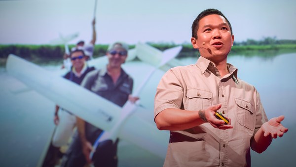
Take for example the case of lions. For centuries, it's been said that female lions do all of the hunting out in the open savanna, and male lions do nothing until it's time for dinner. You've heard this too, I can tell. Well recently, I led an airborne mapping campaign in the Kruger National Park in South Africa. Our colleagues put GPS tracking collars on male and female lions, and we mapped their hunting behavior from the air. The lower left shows a lion sizing up a herd of impala for a kill, and the right shows what I call the lion viewshed. That's how far the lion can see in all directions until his or her view is obstructed by vegetation. And what we found is that male lions are not the lazy hunters we thought them to be. They just use a different strategy. Whereas the female lions hunt out in the open savanna over long distances, usually during the day, male lions use an ambush strategy in dense vegetation, and often at night. This video shows the actual hunting viewsheds of male lions on the left and females on the right. Red and darker colors show more dense vegetation, and the white are wide open spaces. And this is the viewshed right literally at the eye level of hunting male and female lions. All of a sudden, you get a very clear understanding of the very spooky conditions under which male lions do their hunting.
예로 들어 사자의 경우를 볼까요. 수 세기 동안 사람들은 암사자들이 대초원에서 모든 사냥을 도맡아 하고 숫사자들은 식사 시간까지 아무것도 하지 않는다고 말해왔죠. 여러분도 분명히 이렇게 들었을거에요. 최근에 저는 남아공에 있는 크루거 국립공원에서 항공촬영지도 제작 캠페인을 이끌었습니다. 저희 동료들은 GPS 추적 장치를 암사자와 숫사자 목에 달아 놓고 사자들의 사냥 행태를 공중에서 그려 보았어요. 왼쪽 아래는 사자가 사냥감으로 지목한 영양 무리들을 살피는게 보이고 오른쪽에는 사자의 조망 거리를 보여주고 있습니다. 주변 식물들로 인해 시야가 가려지지 않는다면 사자는 모든 방향으로 멀리까지 볼 수 있어요. 또한 우리가 알아낸 것은 숫사자는 생각했던 것처럼 게으른 사냥꾼이 아니라는 거죠. 숫사자는 그저 다른 전략을 사용할 뿐입니다. 암사자가 낮에는 보통 대초원으로 먼 거리로 사냥을 나가는 반면 숫사자는 밤에 무성한 초목 사이에서 잠복하는 전략을 사용합니다. 이 비디오를 통해 왼쪽에서 숫사자의 실질적인 사냥 조망을 볼 수 있고, 오른쪽에서 암사자의 사냥 조망을 보실 수 있습니다. 빨간색과 어두운 색은 더욱 밀집된 초목을 의미하고 하얀색은 넓게 펼쳐진 공간을 표시합니다. 이것은 말 그대로 사냥하는 암사자와 숫사자의 눈높이에서 보는 사냥 조망입니다. 불현듯 숫사자의 사냥 환경이 매우 으스스하다는 생각을 바로 하게 되죠.
I bring up this example to begin, because it emphasizes how little we know about nature. There's been a huge amount of work done so far to try to slow down our losses of tropical forests, and we are losing our forests at a rapid rate, as shown in red on the slide. I find it ironic that we're doing so much, yet these areas are fairly unknown to science. So how can we save what we don't understand?
이 사자 이야기로 시작한 이유는 우리가 자연에 대해 얼마나 모르는지 적나라하게 보여주기 때문입니다. 지금까지 열대우림의 손실을 막으려는 많은 노력을 기울였지만, 슬라이드에서 빨간색으로 표시된 대로 빠른 속도로 숲을 잃어가고 있습니다. 자연과 관계된 정말 많은 일을 하지만 이 지역들이 아직 과학적으로 규명되지 않은 점은 모순이라고 생각합니다. 그렇다면 규명되지 않은 것을 어떻게 보존해야 하나요?
Now I'm a global ecologist and an Earth explorer with a background in physics and chemistry and biology and a lot of other boring subjects, but above all, I'm obsessed with what we don't know about our planet. So I created this, the Carnegie Airborne Observatory, or CAO. It may look like a plane with a fancy paint job, but I packed it with over 1,000 kilos of high-tech sensors, computers, and a very motivated staff of Earth scientists and pilots. Two of our instruments are very unique: one is called an imaging spectrometer that can actually measure the chemical composition of plants as we fly over them. Another one is a set of lasers, very high-powered lasers, that fire out of the bottom of the plane, sweeping across the ecosystem and measuring it at nearly 500,000 times per second in high-resolution 3D. Here's an image of the Golden Gate Bridge in San Francisco, not far from where I live. Although we flew straight over this bridge, we imaged it in 3D, captured its color in just a few seconds. But the real power of the CAO is its ability to capture the actual building blocks of ecosystems. This is a small town in the Amazon, imaged with the CAO. We can slice through our data and see, for example, the 3D structure of the vegetation and the buildings, or we can use the chemical information to actually figure out how fast the plants are growing as we fly over them. The hottest pinks are the fastest-growing plants. And we can see biodiversity in ways that you never could have imagined. This is what a rainforest might look like as you fly over it in a hot air balloon. This is how we see a rainforest, in kaleidoscopic color that tells us that there are many species living with one another. But you have to remember that these trees are literally bigger than whales, and what that means is that they're impossible to understand just by walking on the ground below them. So our imagery is 3D, it's chemical, it's biological, and this tells us not only the species that are living in the canopy, but it tells us a lot of information about the rest of the species that occupy the rainforest.
저는 지구 생태학자이자 탐험가로서 물리와 화학, 생물학 그리고 다른 지루한 학문을 기반으로 하고 있는데 그 중에서도 특히 지구상에서 우리가 모르는 부분을 집중 연구하고 있습니다. 그래서 저는 카네기 항공 전망대, 이름하여 CAO라는 것을 제작했죠. 멋지게 색칠한 비행기처럼 보일 수 있지만 저 안에는 1,000킬로 이상의 첨단 감지기, 컴퓨터를 탑재하고 있고 매우 의욕 넘치는 지구 과학자들과 조종사들도 타고 있습니다. 매우 특별한 두 개의 장비를 보유하고 있는데 하나는 상공에서 실제로 식물의 화학 조성을 측정할 수 있는 영상 분광계라는 것이고, 또 다른 하나는 고성능 레이저 세트입니다. 비행기 아래로 발사해서 전 생태계를 휩쓸고 지나가면 초당 약 오십만 번 정도의 3D 고해상도 측정이 가능하지요. 이 사진은 우리가 사는 곳에서 멀지 않은 샌프란스시코의 금문교입니다. 우리가 이 다리 위로 바로 날아갔지만 불과 몇 초만에 3차원으로 사진을 찍을 수 있습니다. 그러나 CAO의 실제 기능은 생태계의 실질적인 기본 구성 요소를 포착하는 능력입니다. 이것은 CAO로 형상화한 아마존에 있는 작은 마을입니다. 우리는 데이터를 분리해서 볼 수 있는데 예를 들면, 그 위를 비행하면서 식물이나 건물의 입체적인 구조를 볼 수 있고 화학적 정보를 이용해서 식물이 실제로 얼마나 빠르게 성장하는지 알 수 있습니다. 가장 진한 분홍색이 가장 빠르게 성장하는 식물입니다. 우리는 여러분이 상상할 수 없었던 방법으로 생물 다양성을 볼 수 있습니다. 이것은 열기구를 타고 날면서 보는 열대우림 사진입니다. 이것은 우리가 보는 다채로운 색깔의 열대우림으로 다양한 종이 같이 서식하고 있다고 말해줍니다. 하지만 기억해야 할 것은 이런 나무들은 말 그대로 고래보다 더 크고 그래서 나무 아래에 있는 땅을 걷는 것만으로는 그 전부를 알 수 없다는 뜻입니다. 그래서 화학적이고 생물학적인 3 차원 사진은 숲이 우거진 윗부분에 서식하는 종에 대한 정보뿐만 아니라 열대우림을 차지하는 나머지 종에 대해서도 많은 정보을 알려줍니다.
Now I created the CAO in order to answer questions that have proven extremely challenging to answer from any other vantage point, such as from the ground, or from satellite sensors. I want to share three of those questions with you today. The first questions is, how do we manage our carbon reserves in tropical forests? Tropical forests contain a huge amount of carbon in the trees, and we need to keep that carbon in those forests if we're going to avoid any further global warming. Unfortunately, global carbon emissions from deforestation now equals the global transportation sector. That's all ships, airplanes, trains and automobiles combined. So it's understandable that policy negotiators have been working hard to reduce deforestation, but they're doing it on landscapes that are hardly known to science. If you don't know where the carbon is exactly, in detail, how can you know what you're losing? Basically, we need a high-tech accounting system. With our system, we're able to see the carbon stocks of tropical forests in utter detail. The red shows, obviously, closed-canopy tropical forest, and then you see the cookie cutting, or the cutting of the forest in yellows and greens. It's like cutting a cake except this cake is about whale deep. And yet, we can zoom in and see the forest and the trees at the same time. And what's amazing is, even though we flew very high above this forest, later on in analysis, we can go in and actually experience the treetrops, leaf by leaf, branch by branch, just as the other species that live in this forest experience it along with the trees themselves.
자, 제가 CAO를 만든 까닭은 지상에서나 위성 감지기로 봐서는 답하기 어려운 질문에 답을 얻기 위해서입니다. 저는 오늘 세 가지 질문을 드리고 싶습니다. 첫번째 질문은 열대우림 지역에서 탄소저장량을 어떻게 관리해야 할까요? 열대우림은 나무 안에 막대한 탄소를 보존하고 있고, 더 이상의 지구 온난화를 막기 위해서 탄소를 열대 숲 안에 가둬둘 필요가 있습니다. 불행히도 삼림 벌채로 인한 세계적인 탄소 배출량은 전세계 운송 산업과 맥을 같이 합니다. 모든 배, 항공기, 기차, 자동차를 합한 거죠. 그래서 정책 협상자들이 삼림 벌채를 줄이고자 열심히 노력하는게 이해 되지만 그들은 자연경관을 중심으로 일을 하고 있는데 과학을 거의 모른채로 일합니다. 만약 탄소가 정확히 어디에 있는지 모른다면, 구체적으로, 무엇을 잃고 있는지 어떻게 알 수 있을까요? 기본적으로 첨단 회계 시스템이 필요합니다. 그 시스템으로 열대우림의 탄소 축적량을 아주 세밀하게 알 수 있으니까요. 빨간색은 분명하게 지붕 모양으로 덮힌 무성한 숲을 나타내며 그리고 노란색과 녹색은 쿠키를 잘라 낸 것처럼 보이는 열대우림을 나타냅니다. 마치 케익을 잘라낸 것 같죠. 하지만 이 케익은 고래만큼이나 두껍습니다. 그러면서 동시에 우리는 숲과 나무들을 확대해서 자세히 볼 수 있죠. 놀라운 것은 우리가 이 숲 위를 정말 높이 비행한다 하더라도 나중에 분석할 때는 그 나무들과 함께 이 숲에 서식하는 다른 종류의 생물이 느끼는 것처럼 실제로 나무 꼭대기 나뭇잎 하나하나와 나뭇가지들을 느낄 수 있다는 것이죠.
We've been using the technology to explore and to actually put out the first carbon geographies in high resolution in faraway places like the Amazon Basin and not-so-faraway places like the United States and Central America. What I'm going to do is I'm going to take you on a high-resolution, first-time tour of the carbon landscapes of Peru and then Panama. The colors are going to be going from red to blue. Red is extremely high carbon stocks, your largest cathedral forests you can imagine, and blue are very low carbon stocks. And let me tell you, Peru alone is an amazing place, totally unknown in terms of its carbon geography until today. We can fly to this area in northern Peru and see super high carbon stocks in red, and the Amazon River and floodplain cutting right through it. We can go to an area of utter devastation caused by deforestation in blue, and the virus of deforestation spreading out in orange. We can also fly to the southern Andes to see the tree line and see exactly how the carbon geography ends as we go up into the mountain system. And we can go to the biggest swamp in the western Amazon. It's a watery dreamworld akin to Jim Cameron's "Avatar." We can go to one of the smallest tropical countries, Panama, and see also a huge range of carbon variation, from high in red to low in blue. Unfortunately, most of the carbon is lost in the lowlands, but what you see that's left, in terms of high carbon stocks in greens and reds, is the stuff that's up in the mountains. One interesting exception to this is right in the middle of your screen. You're seeing the buffer zone around the Panama Canal. That's in the reds and yellows. The canal authorities are using force to protect their watershed and global commerce. This kind of carbon mapping has transformed conservation and resource policy development. It's really advancing our ability to save forests and to curb climate change.
우리는 과학 기술을 이용하고 있는데 실제로 첫 탄소 지도를 고해상도로 만들기도 했습니다. 아마존 유역 같은 먼 곳이나 그리 멀지 않은 중앙 아메리카나 미국에서 만들었습니다. 여러분에게 보여드릴 사진은 고해상도로 찍은 페루와 파나마의 탄소 경관입니다. 색깔은 빨강색에서 파랑색으로 바뀔 겁니다. 빨강색은 극히 높은 탄소 보유량을 의미하는데 여러분이 상상할 수 있는 가장 큰 숲이겠죠. 그리고 파란색은 매우 낮은 탄소 보유량을 나타냅니다 페루 그 자체로는 탄소 지도 분야에서는 지금까지 거의 알려지지 않는 흥미로운 지역이라는 것을 말씀드리고 싶습니다. 페루의 북부 지역을 비행하며 빨간색으로 표시된 가장 높은 탄소 보유량을 볼 수 있고 아마존 강과 바로 그로 인해 만들어진 범람원도 볼 수 있습니다. 파란색은 삼림벌채로 인하여 완전히 황폐된 지역을 나타내고 산림벌채의 바이러스가 확산된 지역은 주황색으로 표시되어 있어요. 우리는 또한 남부 안데스 산맥을 비행함으로서 형성된 나무 선을 보고 정확히 어떻게 탄소 지도가 끝나는지 뻗어있는 여러 산맥을 통해 알 수 있죠. 그리고 서부 아마존에 있는 가장 큰 늪으로 갑니다. 그곳은 짐 카메론의 영화 "아바타"를 연상시키는 꿈의 습지 세계입니다. 작은 열대 국가 중 하나인 파나마에서 빨간색인 높은 범위에서 낮은 범위의 파란색으로 표시된 엄청나게 다양한 탄소량의 변화를 확인 할 수 있습니다. 불행히도 대부분의 탄소가 저지대에서는 사라졌지만 왼쪽에서 보시다시피 녹색과 빨간색으로 표시된 높은 탄소 보유량은 산 위쪽에 있습니다. 이에 대한 한가지 특이한 사항은 바로 화면 중간입니다. 여러분은 보는 것은 파나마 운하 주변의 완충지대입니다. 빨간색과 노란색으로 표시되어 있구요. 운하 당국은 유역 및 국제 교역을 보호하기 위해 군사력을 사용하고 있습니다. 이러한 탄소 지도 제작은 자연 환경 보존과 자원 정책 개발을 바꾸어 놓습니다. 삼림을 보호하고 기후 변화를 막기위한 인간의 기술 능력은 정말로 진보하고 있죠.
My second question: How do we prepare for climate change in a place like the Amazon rainforest? Let me tell you, I spend a lot of time in these places, and we're seeing the climate changing already. Temperatures are increasing, and what's really happening is we're getting a lot of droughts, recurring droughts. The 2010 mega-drought is shown here with red showing an area about the size of Western Europe. The Amazon was so dry in 2010 that even the main stem of the Amazon river itself dried up partially, as you see in the photo in the lower portion of the slide. What we found is that in very remote areas, these droughts are having a big negative impact on tropical forests. For example, these are all of the dead trees in red that suffered mortality following the 2010 drought. This area happens to be on the border of Peru and Brazil, totally unexplored, almost totally unknown scientifically.
저의 두 번째 질문은 아마존 우림 같은 곳에서는 기후 변화에 대해 어떻게 준비해야 할까요? 저는 많은 시간을 그 곳에서 보내면서 이미 기후 변화를 보고 겪었지요. 기온은 상승하고 우리는 정말 자주 반복되는 가뭄을 겪었습니다. 서유럽 크기 정도의 2010년의 엄청난 가뭄은 여기 빨간색으로 표시되어 있습니다. 2010년에 아마존은 정말 메말랐어요. 슬라이드 아래쪽 사진에서 보다시피 아마존 주요 강줄기조차 부분적으로 메마른 모습을 볼 수 있습니다. 우리는 이러한 가뭄이 외딴 지역에서는 열대우림에 상당히 부정적인 영향을 끼친다는 사실을 알아 냈습니다. 예를 들면, 빨간색으로 표시된 것은 2010년 가뭄으로 죽은 나무들입니다. 이곳은 페루와 브라질의 국경에 접해 있는데 완전 미개척 지역이고 과학적으로 거의 알 수 없는 곳이죠.
So what we think, as Earth scientists, is species are going to have to migrate with climate change from the east in Brazil all the way west into the Andes and up into the mountains in order to minimize their exposure to climate change. One of the problems with this is that humans are taking apart the western Amazon as we speak. Look at this 100-square-kilometer gash in the forest created by gold miners. You see the forest in green in 3D, and you see the effects of gold mining down below the soil surface. Species have nowhere to migrate in a system like this, obviously.
그래서 지구과학자로서 예측하는 것은 기후 변화로 인해 생물종들은 브라질 동쪽에서 서부 안데스 산맥과 산 위쪽으로 이주할 거라는 거죠. 기후 변화로부터 자신을 보호하기 위해서죠. 이것과 연관된 문제 중 하나는 인류가 서부 아마존 지역을 파헤치고 있다는 점입니다. 금 광산업자들이 산림 속에 만들어 놓은 100 평방킬로미터 크기의 잔해물을 보세요. 3D 녹색으로 표시된 숲을 보면 토양 아래쪽에 나타나는 금 광산의 영향을 볼 수 있습니다. 이러한 환경 속에서는 생물들이 이주할 장소가 없는 것은 당연합니다.
If you haven't been to the Amazon, you should go. It's an amazing experience every time, no matter where you go. You're going to probably see it this way, on a river. But what happens is a lot of times the rivers hide what's really going on back in the forest itself. We flew over this same river, imaged the system in 3D. The forest is on the left. And then we can digitally remove the forest and see what's going on below the canopy. And in this case, we found gold mining activity, all of it illegal, set back away from the river's edge, as you'll see in those strange pockmarks coming up on your screen on the right. Don't worry, we're working with the authorities to deal with this and many, many other problems in the region.
아마존에 가 본 적이 없다면 꼭 가보세요. 아마존 어느 지역을 가더라도 매순간 경이로운 경험을 할 것입니다. 여러분은 아마도 강 위에서 이렇게 보겠죠. 하지만 산림 안에서 발생하는 많은 것들을 강이 감춰버립니다. 우리는 똑같은 이 강위를 날아서 생태계를 3차원으로 찍었습니다. 열대우림은 왼쪽입니다. 사진 상에서 숲을 제거하면, 수풀 더미 밑에서 일어나는 일을 볼 수 있죠. 그리고 우리는 불법적인 금광 채굴을 발견했고, 강가에서 떨어져서 오른쪽 화면에 나타나는 이상한 곰보자국을 목격할 것입니다. 걱정 마세요. 이 문제와 더불어 지역적인 여러 많은 문제를 해결하기 위해 우리는 당국과 같이 일하고 있죠.
So in order to put together a conservation plan for these unique, important corridors like the western Amazon and the Andes Amazon corridor, we have to start making geographically explicit plans now. How do we do that if we don't know the geography of biodiversity in the region, if it's so unknown to science? So what we've been doing is using the laser-guided spectroscopy from the CAO to map for the first time the biodiversity of the Amazon rainforest. Here you see actual data showing different species in different colors. Reds are one type of species, blues are another, and greens are yet another. And when we take this together and scale up to the regional level, we get a completely new geography of biodiversity unknown prior to this work. This tells us where the big biodiversity changes occur from habitat to habitat, and that's really important because it tells us a lot about where species may migrate to and migrate from as the climate shifts. And this is the pivotal information that's needed by decision makers to develop protected areas in the context of their regional development plans.
서부 아마존과 안데스 지역 아마존과 같은 특이하고 중요한 거점을 위한 자연 보존 계획을 설립하기 위해는 지리학적으로 확실한 계획을 가지고 시작해야 합니다. 만약 그 지역에서 생물의 다양성을 지리학적으로 알지 못하고 또한 과학적으로 알지 못한다면 어떻게 할 수 있을까요? 그래서 우리가 해 온 것은 CAO의 레이저 유도 분광학을 사용해서 아마존 우림의 생물 다양성 지도를 최초로 만드는 일입니다. 여러분이 여기서 보시는 데이터는 다른 색상으로 서로 다른 종을 보여줍니다. 빨간색은 하나의 종이고 파란색은 다른 종이며 그리고 녹색은 또 다른 종입니다. 우리가 이것을 지역적인 차원으로 함께 확대 시키면 전에는 알려지지 않은 생물의 다양성 측면에서 완전히 새로운 지도를 갖게 됩니다. 이 의미는 어디서 생물의 다양성 변화가 크게 일어나는지를 서식지별로 보여주고, 이것은 기후 변화가 일어남에 따라 종들이 어디에서 어디로 이동하는지 알려줄 수 있기 때문에 아주 중요합니다. 그리고 이것은 결정권자가 보호된 지역을 개발하기 위해서는 지역적인 개발 계획 선상에서 절대적으로 필요한 중심적 정보입니다.
And third and final question is, how do we manage biodiversity on a planet of protected ecosystems? The example I started out with about lions hunting, that was a study we did behind the fence line of a protected area in South Africa. And the truth is, much of Africa's nature is going to persist into the future in protected areas like I show in blue on the screen. This puts incredible pressure and responsibility on park management. They need to do and make decisions that will benefit all of the species that they're protecting. Some of their decisions have really big impacts. For example, how much and where to use fire as a management tool? Or, how to deal with a large species like elephants, which may, if their populations get too large, have a negative impact on the ecosystem and on other species. And let me tell you, these types of dynamics really play out on the landscape. In the foreground is an area with lots of fire and lots of elephants: wide open savanna in blue, and just a few trees. As we cross this fence line, now we're getting into an area that has had protection from fire and zero elephants: dense vegetation, a radically different ecosystem. And in a place like Kruger, the soaring elephant densities are a real problem. I know it's a sensitive issue for many of you, and there are no easy answers with this. But what's good is that the technology we've developed and we're working with in South Africa, for example, is allowing us to map every single tree in the savanna, and then through repeat flights we're able to see which trees are being pushed over by elephants, in the red as you see on the screen, and how much that's happening in different types of landscapes in the savanna. That's giving park managers a very first opportunity to use tactical management strategies that are more nuanced and don't lead to those extremes that I just showed you. So really, the way we're looking at protected areas nowadays is to think of it as tending to a circle of life, where we have fire management, elephant management, those impacts on the structure of the ecosystem, and then those impacts affecting everything from insects up to apex predators like lions.
그리고 마지막으로 세번째 질문은 우리는 보호된 생태계 안에서 지구 상의 생물 다양성을 어떻게 관리해야 할까요? 처음 시작할 때 했던 사자들의 사냥 행태 예제는 남아프리카 공화국의 보호구역 울타리 뒤에서 연구했던 것입니다. 또한 사실, 많은 아프리카의 자연은 화면 상에서 파란색으로 표시된 보호 구역 안에서 미래를 위해 유지되고 있습니다. 이것은 공원 관리 운영에 있어 엄청난 압력과 책임이 뒤따릅니다. 그들이 보호하는 모든 종에게 이득이 되도록 의사결정을 할 필요가 있습니다. 어떤 결정은 정말로 큰 영향을 끼칩니다. 예를 들면, 관리 도구로써 불을 이용할 때는 얼마나 많이, 어디에 불을 써야 할까요? 또는 코끼리 같은 큰 종은 어떻게 다루어야 하는지 만약 그 개체 집단이 너무 커져 생태계와 다른 생물의 종에 부정적인 영향이 있는 경우에 내려지는 결정은 종에게 큰 영향을 끼칩니다. 말씀드리자면, 이런 종류의 역동성은 경관에 정말로 영향을 미칩니다. 앞에 보이는 것은 불이 많이 나고 코끼리가 많은 지역입니다. 파란색으로 표시된 드넓은 열대 초원과 몇몇 나무들. 이 울타리 선을 넘으면, 우리는 화재로부터 보호되고 코끼리가 없는 보호 구역으로 들어 가게 됩니다. 무성한 초원, 근본적으로 다른 생태계이죠. 그리고 크루거같은 지역에서 코끼리 밀도가 높아지는 것은 큰 문제입니다. 많은 사람들들이 이건 민감한 문제라고 생각하지만, 간단한 해결책은 없습니다. 긍정적인 점은 우리가 발전시킨 과학기술입니다. 예를 들면, 남아프리카 공화국에서는 열대 초원에 있는 나무 하나하나를 지도화 할 수 있고 반복적인 비행을 통해 코끼리가 어느 나무를 밀어 넘어뜨리는지 알 수 있습니다. 화면에 표시된 빨간색에서 열대 초원의 서로 다른 지역에서 얼마나 자주 그 일이 발생하는지 알 수 있습니다. 공원 관리자는 치밀한 관리 전략을 사용할 첫 기회를 갖게 되고, 전술적인 관리 전략은 좀 더 미묘한 차이가 있지만 여러분이 보셨던 극단으로 이어지지는 않습니다. 따라서 요즈음 실제로 보호구역을 바라보는 방법은 그것을 생명 순환의 경향으로 여기는 것입니다. 불을 관리하는 곳과 코끼리를 관리하는 곳은 생태계 구조에 영향을 주고, 그 다음 이 영향은 곤충에서부터 사자 같은 포식 동물의 왕에 이르기까지 영향을 미치는 거죠.
Going forward, I plan to greatly expand the airborne observatory. I'm hoping to actually put the technology into orbit so we can manage the entire planet with technologies like this. Until then, you're going to find me flying in some remote place that you've never heard of. I just want to end by saying that technology is absolutely critical to managing our planet, but even more important is the understanding and wisdom to apply it.
앞으로 저는 항공 관찰을 더 확장할 계획입니다. 과학기술을 실제 궤도에 올려 놓아서 지구 전체를 이같은 과학기술로 관리할 수 있기를 희망합니다. 그때까지 저는 아마 여러분이 전혀 들어 보지 못한 지역을 비행하고 있겠죠. 끝으로 말씀드리고 싶은 것은 지구를 유지하는 데 과학기술이 절대적으로 중요하지만 실천하기 위해서는 이해와 지혜가 더 중요하다는 점입니다.
Thank you.
감사합니다.
(Applause)
(박수)