Technologie kann unser Naturverständnis verändern.
Technology can change our understanding of nature.
Denken Sie beispielsweise an Löwen. Seit Jahrhunderten sagt man, dass die Löwinnen die ganze Jagd in der Savanne erledigen und die Löwenmännchen bis zum Abendmahl nichts tun. Sie haben sicher auch davon gehört. Vor kurzem leitete ich im Krüger Nationalpark, Südafrika, ein Kartografie-Projekt aus der Luft. Unsere Kollegen legten den Löwen und Löwinnen Halsbänder mit GPS-Sendern an, und wir zeichneten ihr Jagdverhalten aus der Luft auf. Unten links sehen Sie einen Löwen, der hungrig eine Herde Impalas beobachtet, und die rechte Seite zeigt den Blickwinkel des Löwen. So weit kann der Löwe in alle Richtungen sehen, bis sein Blick durch die Vegetation behindert wird. Wir fanden heraus, dass männliche Löwen nicht die faulen Jäger sind, für die wir sie hielten. Sie nutzen nur eine andere Strategie. Während die Löwinnen in der offenen Savanne über lange Distanzen und gewöhnlich tagsüber jagen, greifen Löwenmännchen aus dem Hinterhalt in dichter Vegetation an und jagen oft nachts. Dieses Video zeigt die tatsächlichen Jagd-Perspektiven der männlichen Löwen links und der weiblichen rechts. Rote und dunklere Farben zeigen dichtere Vegetation, und hellere Farben weite, offene Flächen. Dies ist die Perspektive direkt auf Augenhöhe der jagenden männlichen und weiblichen Löwen. Plötzlich versteht man die gespenstischen Bedingungen, unter denen männliche Löwen jagen.
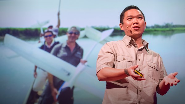
Take for example the case of lions. For centuries, it's been said that female lions do all of the hunting out in the open savanna, and male lions do nothing until it's time for dinner. You've heard this too, I can tell. Well recently, I led an airborne mapping campaign in the Kruger National Park in South Africa. Our colleagues put GPS tracking collars on male and female lions, and we mapped their hunting behavior from the air. The lower left shows a lion sizing up a herd of impala for a kill, and the right shows what I call the lion viewshed. That's how far the lion can see in all directions until his or her view is obstructed by vegetation. And what we found is that male lions are not the lazy hunters we thought them to be. They just use a different strategy. Whereas the female lions hunt out in the open savanna over long distances, usually during the day, male lions use an ambush strategy in dense vegetation, and often at night. This video shows the actual hunting viewsheds of male lions on the left and females on the right. Red and darker colors show more dense vegetation, and the white are wide open spaces. And this is the viewshed right literally at the eye level of hunting male and female lions. All of a sudden, you get a very clear understanding of the very spooky conditions under which male lions do their hunting.
Ich begann mit diesem Beispiel, weil es unterstreicht, wie wenig wir über die Natur wissen. Es wurde bereits enorm viel getan, um zu versuchen, den Verlust der Regenwälder zu verlangsamen. Wir verlieren unsere Wälder sehr rasch, wie die rote Farbe hier zeigt. Für mich ist es ironisch, dass wir so viel tun, und doch sind diese Gebiete der Forschung fast unbekannt. Wie können wir retten, was wir nicht verstehen?
I bring up this example to begin, because it emphasizes how little we know about nature. There's been a huge amount of work done so far to try to slow down our losses of tropical forests, and we are losing our forests at a rapid rate, as shown in red on the slide. I find it ironic that we're doing so much, yet these areas are fairly unknown to science. So how can we save what we don't understand?
Ich bin ein globaler Ökologe und ein Erderforscher, habe Physik, Chemie, Biologie und viele andere, langweilige Fächer studiert, aber am allermeisten interessiert mich, was wir über unseren Planeten nicht wissen. Also baute ich dies, das Carnegie Airborne Observatory, or CAO. Es sieht aus wie ein lustiges Malprojekt, aber an Bord sind über 1 000 kg High-Tech-Sensoren, Computer und eine sehr motivierte Besatzung aus Geowissenschaftlern und Piloten. Zwei unserer Instrumente sind einzigartig: Ein Bild-Spektrometer, das die chemische Zusammensetzung von Pflanzen bestimmen kann, über die wir gerade fliegen. Dann noch ein Set aus Lasern, sehr leistungsstarken Lasern, die vom Flugzeugrumpf aus über das Ökosystem hinweggefeuert werden, und dieses dann fast 500 000-mal pro Sekunde in hochauflösendem 3D messen. Hier ist ein Bild der Golden Gate Bridge in San Francisco, nahe meines Wohnorts. Obwohl wir nur kurz darüber flogen, konnten wir sie in nur wenigen Sekunden in 3D zeichnen und ihre Farbe abspeichern. Aber die wahre Kraft des CAO liegt in seiner Fähigkeit, Bausteine von Ökosystemen zu erfassen. Das ist eine kleine Stadt im Amazonas, aufgenommen mit dem CAO. Wir können die Daten aufsplitten und beispielsweise die 3D-Struktur der Vegetation und der Gebäude sehen, oder die chemischen Informationen nutzen, um herauszufinden, wie schnell die Pflanzen wachsen, während wir darüber fliegen. Je dunkler das Pink, desto schneller wachsen sie. Artenvielfalt ist auf eine Weise sichtbar, die früher unvorstellbar war. So könnte ein Regenwald aussehen, wenn man im Heißluftballon darüber fliegt. So sehen wir einen Regenwald: in kaleidoskopischen Farben, die uns zeigen, dass es viele Spezies gibt, die dort miteinander leben. Aber vergessen Sie nicht, dass diese Bäume größer als Wale sind und dass man sie nicht verstehen kann, wenn man nur auf dem Boden unter ihnen läuft. Es sind 3D-Bilder mit chemischen und biologischen Informationen, die uns nicht nur die Spezies zeigen, die in den Baumkronen leben, wir bekommen auch viele Informationen über die restlichen Arten im Regenwald.
Now I'm a global ecologist and an Earth explorer with a background in physics and chemistry and biology and a lot of other boring subjects, but above all, I'm obsessed with what we don't know about our planet. So I created this, the Carnegie Airborne Observatory, or CAO. It may look like a plane with a fancy paint job, but I packed it with over 1,000 kilos of high-tech sensors, computers, and a very motivated staff of Earth scientists and pilots. Two of our instruments are very unique: one is called an imaging spectrometer that can actually measure the chemical composition of plants as we fly over them. Another one is a set of lasers, very high-powered lasers, that fire out of the bottom of the plane, sweeping across the ecosystem and measuring it at nearly 500,000 times per second in high-resolution 3D. Here's an image of the Golden Gate Bridge in San Francisco, not far from where I live. Although we flew straight over this bridge, we imaged it in 3D, captured its color in just a few seconds. But the real power of the CAO is its ability to capture the actual building blocks of ecosystems. This is a small town in the Amazon, imaged with the CAO. We can slice through our data and see, for example, the 3D structure of the vegetation and the buildings, or we can use the chemical information to actually figure out how fast the plants are growing as we fly over them. The hottest pinks are the fastest-growing plants. And we can see biodiversity in ways that you never could have imagined. This is what a rainforest might look like as you fly over it in a hot air balloon. This is how we see a rainforest, in kaleidoscopic color that tells us that there are many species living with one another. But you have to remember that these trees are literally bigger than whales, and what that means is that they're impossible to understand just by walking on the ground below them. So our imagery is 3D, it's chemical, it's biological, and this tells us not only the species that are living in the canopy, but it tells us a lot of information about the rest of the species that occupy the rainforest.
Ich habe das CAO gebaut, um Fragen zu beantworten, die aus jedem anderen Blickwinkel sehr schwer zu beantworten sind; etwa vom Boden aus oder mit Satelliten-Sensoren. Ich will Ihnen heute drei dieser Fragen vorstellen. Die erste Frage lautet: Wie werden die Kohlenstoff-Reserven in tropischen Wäldern von uns verwaltet? Bäume in tropischen Wäldern enthalten eine große Menge Kohlenstoff, und der Kohlenstoff muss in diesen Wäldern bleiben, wenn wir eine weitere Erderwärmung verhindern wollen. Leider ähneln die CO2-Emissionen durch Abholzung mittlerweile dem globalen Transportsektor. Das sind alle Schiffe, Flugzeuge, Züge und Autos zusammen. Darum ist es verständlich, dass die Entscheidungsträger hart daran arbeiten, die Abholzung zu verringern. Aber sie verhandeln über Landschaften, die der Wissenschaft großteils unbekannt sind. Wenn man nicht genau weiß, wo der Kohlenstoff ist, wie soll man dann wissen, was man verliert? Darum brauchen wir ein hochwertiges Berechnungssystem. Mit unserem System können wir die Kohlenstofflager in tropischen Wäldern sehr detailliert sehen. In Rot hier die dichten Baumkronen des Regenwaldes, dann sehen Sie hier ein Kuchenstück, einen Ausschnitt des Waldes in Gelb und Grün. Das ist wie ein Kuchenstück, nur hat dieser Kuchen die Größe eines Wals. Dennoch können wir hineinzoomen und den Wald und die Bäume gleichzeitig sehen. Obwohl wir in großer Höhe über diesen Wald flogen, können wir später in der Analyse erstaunlicherweise die Baumgipfel Blatt für Blatt und Zweig für Zweig erleben, so wie wir die anderen Arten in diesem Wald gemeinsam mit den Bäumen selbst sehen können.
Now I created the CAO in order to answer questions that have proven extremely challenging to answer from any other vantage point, such as from the ground, or from satellite sensors. I want to share three of those questions with you today. The first questions is, how do we manage our carbon reserves in tropical forests? Tropical forests contain a huge amount of carbon in the trees, and we need to keep that carbon in those forests if we're going to avoid any further global warming. Unfortunately, global carbon emissions from deforestation now equals the global transportation sector. That's all ships, airplanes, trains and automobiles combined. So it's understandable that policy negotiators have been working hard to reduce deforestation, but they're doing it on landscapes that are hardly known to science. If you don't know where the carbon is exactly, in detail, how can you know what you're losing? Basically, we need a high-tech accounting system. With our system, we're able to see the carbon stocks of tropical forests in utter detail. The red shows, obviously, closed-canopy tropical forest, and then you see the cookie cutting, or the cutting of the forest in yellows and greens. It's like cutting a cake except this cake is about whale deep. And yet, we can zoom in and see the forest and the trees at the same time. And what's amazing is, even though we flew very high above this forest, later on in analysis, we can go in and actually experience the treetrops, leaf by leaf, branch by branch, just as the other species that live in this forest experience it along with the trees themselves.
Wir haben diese Technik eingesetzt, um die erste CO2-Landkarte in hoher Auflösung zu erstellen, an abgelegenen Orten wie dem Amazonasbecken und näher gelegenen wie den USA und Mittelamerika. Ich nehme Sie jetzt mit auf Ihre erste hochauflösende Reise durch die CO2-Landschaft Perus und Panamas. Die Farben reichen von Rot bis Blau. Rot sind die großen Kohlenstofflager in den größten Wäldern, die Sie sich vorstellen können, und blau sind kleine Kohlenstofflager. Peru allein ist schon ein erstaunliches Land, und bis heute vollkommen unbekannt hinsichtlich seiner CO2-Landschaft. Wir fliegen ins nördliche Peru und sehen enorme CO2-Lager in Rot, den Amazonas und seine Überschwemmungsgebiete und fliegen mitten durch sie. Wir kommen zu einem verwüsteten Gebiet, verursacht durch die Abholzung in Blau. Der Abholzungsvirus breitet sich in Orange aus. Fliegen wir jetzt zu den südlichen Anden, schauen wir uns die Baumgrenze und das Ende der CO2-Geografie an, während wir in die Berge reisen. Hier ist das größte Sumpfgebiet des westlichen Amazonas, eine Traumwelt aus Wasser, ähnlich wie in James Camerons "Avatar". Reisen wir jetzt zu einem der kleinsten tropischen Länder, Panama, mit einer enormen CO2-Variation, von hoch in Rot bis niedrig in Blau. Leider geht im Tiefland viel CO2 verloren, aber was übrigbleibt, sind hohe CO2-Lager in Grün und Rot, die auf den Bergen liegen. Eine interessante Ausnahme dabei sehen Sie in der Bildmitte. Das ist die Pufferzone um den Panamakanal. Dort gibt es Rot und Gelb. Die Kanalbehörden schützen ihre Wasserscheide und ihren globalen Handel mit Nachdruck. Diese Art CO2-Kartierung hat die Maßnahmen zum Schutz und der Erschließung von Ressourcen verändert. Unsere Möglichkeiten zur Rettung von Wäldern und dem Eindämmen des Klimawandels steigen.
We've been using the technology to explore and to actually put out the first carbon geographies in high resolution in faraway places like the Amazon Basin and not-so-faraway places like the United States and Central America. What I'm going to do is I'm going to take you on a high-resolution, first-time tour of the carbon landscapes of Peru and then Panama. The colors are going to be going from red to blue. Red is extremely high carbon stocks, your largest cathedral forests you can imagine, and blue are very low carbon stocks. And let me tell you, Peru alone is an amazing place, totally unknown in terms of its carbon geography until today. We can fly to this area in northern Peru and see super high carbon stocks in red, and the Amazon River and floodplain cutting right through it. We can go to an area of utter devastation caused by deforestation in blue, and the virus of deforestation spreading out in orange. We can also fly to the southern Andes to see the tree line and see exactly how the carbon geography ends as we go up into the mountain system. And we can go to the biggest swamp in the western Amazon. It's a watery dreamworld akin to Jim Cameron's "Avatar." We can go to one of the smallest tropical countries, Panama, and see also a huge range of carbon variation, from high in red to low in blue. Unfortunately, most of the carbon is lost in the lowlands, but what you see that's left, in terms of high carbon stocks in greens and reds, is the stuff that's up in the mountains. One interesting exception to this is right in the middle of your screen. You're seeing the buffer zone around the Panama Canal. That's in the reds and yellows. The canal authorities are using force to protect their watershed and global commerce. This kind of carbon mapping has transformed conservation and resource policy development. It's really advancing our ability to save forests and to curb climate change.
Meine zweite Frage: Wie sollen wir uns auf den Klimawandel an Orten wie dem Amazonas-Regenwald vorbereiten? Ich verbringe sehr viel Zeit an solchen Orten, und dort ist der Klimawandel schon erkennbar. Temperaturen steigen. Wir erleben wirklich viele Dürren, wiederkehrende Dürren. Hier sehen Sie die Mega-Dürre 2010 in Rot in etwa der Größe Westeuropas. 2010 war der Amazonas so trocken, dass sogar der Hauptarm des Flusses selbst teilweise austrocknete, wie Sie hier weiter unten im Bild sehen können. In sehr abgelegenen Gebieten haben diese Dürren schwere Folgen für tropische Wälder. Die toten Bäume in Rot starben während der Dürre 2010. Dieses Gebiet liegt an der Grenze zwischen Peru und Brasilien und ist völlig unerforscht und der Wissenschaft kaum bekannt.
My second question: How do we prepare for climate change in a place like the Amazon rainforest? Let me tell you, I spend a lot of time in these places, and we're seeing the climate changing already. Temperatures are increasing, and what's really happening is we're getting a lot of droughts, recurring droughts. The 2010 mega-drought is shown here with red showing an area about the size of Western Europe. The Amazon was so dry in 2010 that even the main stem of the Amazon river itself dried up partially, as you see in the photo in the lower portion of the slide. What we found is that in very remote areas, these droughts are having a big negative impact on tropical forests. For example, these are all of the dead trees in red that suffered mortality following the 2010 drought. This area happens to be on the border of Peru and Brazil, totally unexplored, almost totally unknown scientifically.
Als Geowissenschaftler glauben wir, dass Tiere vor dem Klimawandel vom Osten Brasiliens in den Westen bis zu den Anden und in die Berge flüchten müssen, um seine Auswirkungen auf sie zu minimieren. Eines der Probleme dabei ist, dass Menschen derzeit den westlichen Amazonas auseinandernehmen. Schauen Sie sich diese 100 km²-Wunde im Wald an, die von Goldminenarbeitern geschaffen wurde. Sie sehen den Wald in Grün in 3D und die Auswirkungen der Goldminen unter dem Boden. In einem solchen System können Tiere natürlich nirgends hinwandern.
So what we think, as Earth scientists, is species are going to have to migrate with climate change from the east in Brazil all the way west into the Andes and up into the mountains in order to minimize their exposure to climate change. One of the problems with this is that humans are taking apart the western Amazon as we speak. Look at this 100-square-kilometer gash in the forest created by gold miners. You see the forest in green in 3D, and you see the effects of gold mining down below the soil surface. Species have nowhere to migrate in a system like this, obviously.
Falls Sie noch nie im Amazonas waren, sollten Sie hinfahren. Es ist jedes Mal eine wunderbare Erfahrung, egal, wohin man geht. Vielleicht sehen Sie ihn wie hier von einem Fluss aus. Aber oft verbergen die Flüsse, was im Wald selbst wirklich vor sich geht. Wir flogen über denselben Fluss und machten Aufnahmen in 3D. Der Wald ist links. Jetzt entfernen wir den Wald im Bild und sehen, was unter den Baumkronen passiert. Hier fanden wir Goldminen, alle illegal, weiter weg vom Flussufer, wie Sie an diesen eigenartigen Pockennarben auf dem Bild rechts erkennen können. Keine Sorge, wir arbeiten mit den Behörden, um Lösungen für dieses und viele andere Probleme in der Region zu finden.
If you haven't been to the Amazon, you should go. It's an amazing experience every time, no matter where you go. You're going to probably see it this way, on a river. But what happens is a lot of times the rivers hide what's really going on back in the forest itself. We flew over this same river, imaged the system in 3D. The forest is on the left. And then we can digitally remove the forest and see what's going on below the canopy. And in this case, we found gold mining activity, all of it illegal, set back away from the river's edge, as you'll see in those strange pockmarks coming up on your screen on the right. Don't worry, we're working with the authorities to deal with this and many, many other problems in the region.
Zur Planung von Schutzmaßnahmen für diese einzigartigen, wichtigen Korridore wie den westlichen Amazonas und den Anden-Amazonas-Korridor benötigen wir jetzt geografisch aussagekräftige Karten. Wie soll das gehen, wenn wir die Geografie der Artenvielfalt in der Region nicht kennen, wenn die Wissenschaft sie nicht kennt? Wir haben also die Laser-Spektroskopie der CAO genutzt, um erstmals die Artenvielfalt im Amazonas-Regenwald zu zeigen. Diese Daten zeigen die verschiedenen Spezies in verschiedenen Farben. Eine Spezies ist rot, die andere blau, und wieder eine andere ist grün. Wenn wir das zusammenfügen und auf die Region hochrechnen, erhalten wir eine völlig neue Geografie der Artenvielfalt, die es vorher nicht gab. So werden die großen Veränderungen in der Artenvielfalt je nach Lebensraum sichtbar, und das ist wirklich wichtig, da es viel darüber sagt, wohin Tiere im Zuge des Klimawandels hinwandern und von wo sie abwandern können. Das ist die essentiell notwendige Information für Entscheidungsträger, um Schutzgebiete im Zuge ihrer regionalen Entwicklungsplänen zu schaffen.
So in order to put together a conservation plan for these unique, important corridors like the western Amazon and the Andes Amazon corridor, we have to start making geographically explicit plans now. How do we do that if we don't know the geography of biodiversity in the region, if it's so unknown to science? So what we've been doing is using the laser-guided spectroscopy from the CAO to map for the first time the biodiversity of the Amazon rainforest. Here you see actual data showing different species in different colors. Reds are one type of species, blues are another, and greens are yet another. And when we take this together and scale up to the regional level, we get a completely new geography of biodiversity unknown prior to this work. This tells us where the big biodiversity changes occur from habitat to habitat, and that's really important because it tells us a lot about where species may migrate to and migrate from as the climate shifts. And this is the pivotal information that's needed by decision makers to develop protected areas in the context of their regional development plans.
Die dritte und letzte Frage ist: Wie verwalten wir Artenvielfalt auf einem Planeten mit ökologischen Schutzgebieten? Das Beispiel am Anfang mit der Löwenjagd war eine Studie, die wir im Inneren eines Schutzgebietes in Südafrika durchgeführt haben. Ein Großteil der afrikanischen Wildnis wird in der Zukunft weiter in Schutzgebieten wie hier im Bild in Blau bestehen bleiben. Das bedeutet viel Druck und Verantwortung für die Parkverwaltung. Sie muss Entscheidungen treffen, die allen Spezies nützen, die sie beschützt. Manche ihrer Entscheidungen haben schwerwiegende Folgen. Zum Beispiel, wie oft und wo soll man Feuer als Verwaltungswerkzeug einsetzen? Oder wie soll man mit großen Tieren wie Elefanten umgehen, die -- falls sie zu zahlreich werden -- negative Folgen auf das Ökosystem und andere Arten haben? Diese Dynamiken wirken sich stark auf die Landschaft aus. Im Bild vorne ist ein Gebiet mit viel Feuer und vielen Elefanten: Die weite, offene Savanne in Blau, und nur ein paar wenige Bäume. Wir überschreiten den Grenzzaun und kommen in ein Gebiet, das vor Feuer geschützt ist und keine Elefanten hat. Dichte Vegetation, ein völlig anderes Ökosystem. An einem Ort wie Krüger ist die steigende Zahl an Elefanten ein echtes Problem. Ich weiß, das ist hier für viele ein heikles Thema, und es gibt darauf keine einfachen Antworten. Glücklicherweise erlaubt es uns unsere Technologie, die wir zum Beispiel in Südafrika einsetzen, jeden einzelnen Baum in der Savanne aufzuzeichnen. Durch wiederholte Flüge sehen wir dann, welche Bäume von den Elefanten niedergetrampelt werden, wie hier in Rot im Bild, und wie oft das in verschiedenen Landschaften in der Savanne passiert. So erhält die Parkverwaltung erstmalig die Gelegenheit, taktische und differenziertere Strategien einzusetzen, die nicht zu solchen Extremen wie vorhin führen. Wir sehen Schutzzonen heutzutage als Pflege eines Lebenszyklus, wo der Umgang mit Feuer und Elefanten geplant wird, was die Struktur des Ökosystems beeinflusst. Es gibt auch jene Faktoren, die alles, von Insekten bis zu großen Raubtieren wie Löwen beeinflussen.
And third and final question is, how do we manage biodiversity on a planet of protected ecosystems? The example I started out with about lions hunting, that was a study we did behind the fence line of a protected area in South Africa. And the truth is, much of Africa's nature is going to persist into the future in protected areas like I show in blue on the screen. This puts incredible pressure and responsibility on park management. They need to do and make decisions that will benefit all of the species that they're protecting. Some of their decisions have really big impacts. For example, how much and where to use fire as a management tool? Or, how to deal with a large species like elephants, which may, if their populations get too large, have a negative impact on the ecosystem and on other species. And let me tell you, these types of dynamics really play out on the landscape. In the foreground is an area with lots of fire and lots of elephants: wide open savanna in blue, and just a few trees. As we cross this fence line, now we're getting into an area that has had protection from fire and zero elephants: dense vegetation, a radically different ecosystem. And in a place like Kruger, the soaring elephant densities are a real problem. I know it's a sensitive issue for many of you, and there are no easy answers with this. But what's good is that the technology we've developed and we're working with in South Africa, for example, is allowing us to map every single tree in the savanna, and then through repeat flights we're able to see which trees are being pushed over by elephants, in the red as you see on the screen, and how much that's happening in different types of landscapes in the savanna. That's giving park managers a very first opportunity to use tactical management strategies that are more nuanced and don't lead to those extremes that I just showed you. So really, the way we're looking at protected areas nowadays is to think of it as tending to a circle of life, where we have fire management, elephant management, those impacts on the structure of the ecosystem, and then those impacts affecting everything from insects up to apex predators like lions.
Ich möchte die Beobachtung aus der Luft nach und nach stark ausweiten. Vielleicht funktioniert sie auch aus dem Weltall, um den gesamten Planeten auf diese Weise verwalten zu können. Bis dahin kann man mich beim Überfliegen abgelegener und Ihnen unbekannter Gebiete antreffen. Abschließend möchte ich sagen, dass Technologie entscheidend für die Verwaltung unseres Planeten ist, aber noch wichtiger ist das Verständnis und die Weisheit des richtigen Einsatzes.
Going forward, I plan to greatly expand the airborne observatory. I'm hoping to actually put the technology into orbit so we can manage the entire planet with technologies like this. Until then, you're going to find me flying in some remote place that you've never heard of. I just want to end by saying that technology is absolutely critical to managing our planet, but even more important is the understanding and wisdom to apply it.
Vielen Dank.
Thank you.
(Applaus)
(Applause)