تستطيع التقنيات الحديثة ان تغير فهمنا للطبيعة
Technology can change our understanding of nature.
لنأحذ على سبيل المثال مثال "الأسود" لعدة عقود من الزمان، قيل أن إناث الأسود هيا من تقوم بالصيد في سهول السافانا، والأسود الذكور لا تفعل شيئا إلى ان يحين وقت الغذاء. سمعتم هذا ايضا من قبل، يمكنني الجزم بهذا. ولكنني قدت مؤخرا حملة جوية لرسم الخرائط في حديقة كروجو الوطنية في جنوب افريقيا. وقد وضع زملائنا في الحملة أطواق تتبع في رقاب ذكور وإناث الأسود، وقمنا بملاحظة وتسجيل سلوكيات الصيد الخاصة بهم من الجو. يظهر اسفل اليسار أسد يلتفت إلى قطيع من الظبيان ليصطاد أحدهم وفي اليمين يظهر ما أطلق عليه نطاق رؤية الأسد. وهو ما يستطيع الأسد أن يراه في جميع الاتجاهات حتى ان تعيق النباتات رؤية ذكر أو أنثى الأسد ولكن ما وجدناه أن ذكور الأسود ليست بصيادين كسالى كما كنا نعتقد. ولكنهم استخدموا طريقة مختلفة. وفي حين كانت إناث الأسود تطارد الفرائس في سهول السافانا الكبيرة لمسافات طويلة، وعادة في خلال النهار، استخدم ذكور الأسود طريقة الكمين في داخل النباتات الكثيفة، وغالبا تحت غطاء الليل. ويرينا هذا الفيديو مدى الرؤية الحقيقي للمطاردات لذكور الأسود من ناحية اليسار ولإناث الأسود من اليمين يظهر اللون الأحمر، والألوان الداكنة كثافة نباتية عالية، بينما يظهر اللون الابيض المساحات المفتوحة الشاسعة. وهذا هو مدى الرؤية الفعلي على مستوى العين المجردة لكل من ذكور وإناث الأسود وكانت مفاجأة للجميع، ان حصلنا على فهم واضح للغاية للحالات المجفلة والتي بموجبها يصطاد ذكور الأسود فرائسهم.
Take for example the case of lions. For centuries, it's been said that female lions do all of the hunting out in the open savanna, and male lions do nothing until it's time for dinner. You've heard this too, I can tell. Well recently, I led an airborne mapping campaign in the Kruger National Park in South Africa. Our colleagues put GPS tracking collars on male and female lions, and we mapped their hunting behavior from the air. The lower left shows a lion sizing up a herd of impala for a kill, and the right shows what I call the lion viewshed. That's how far the lion can see in all directions until his or her view is obstructed by vegetation. And what we found is that male lions are not the lazy hunters we thought them to be. They just use a different strategy. Whereas the female lions hunt out in the open savanna over long distances, usually during the day, male lions use an ambush strategy in dense vegetation, and often at night. This video shows the actual hunting viewsheds of male lions on the left and females on the right. Red and darker colors show more dense vegetation, and the white are wide open spaces. And this is the viewshed right literally at the eye level of hunting male and female lions. All of a sudden, you get a very clear understanding of the very spooky conditions under which male lions do their hunting.
طرحت هذا المثال في البداية، لأنه يؤكد مدى قلة ما نعرفه عن الطبيعة. وقد قام الباحثون بإنجاز كم هائل من الابحاث حتى الآن لمحاولة تقليل وإبطاء أختفاء مساحات الغابات الاستوائية ومازلنا نسخر غاباتنا الاستوائية بمعدل مخيف كما هو موضح باللون الاحمر على الشاشة واجد من سخرية القدر بالرغم من كل هذه الابحاث ولكن تظل هذه المناطق معروفة بالكاد للعلوم. فكيف يمكننا إنقاذ ما لا نفهمه
I bring up this example to begin, because it emphasizes how little we know about nature. There's been a huge amount of work done so far to try to slow down our losses of tropical forests, and we are losing our forests at a rapid rate, as shown in red on the slide. I find it ironic that we're doing so much, yet these areas are fairly unknown to science. So how can we save what we don't understand?
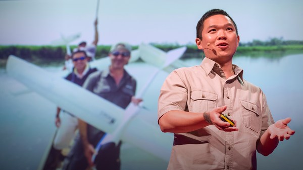
انا الآن عالم بيئة ومستكشف دولي ولدي خلفية في الفيزياء والكمياء وعلم الأحياء والكثير من العلوم الأخرى المملة، ولكن قبل أي شيء، انا مهووس بما لا نعرفه عن كوكبنا لذلك قمت بعمل مرصد كارنيجي الجوي، أو ما يعرف بـ CAO قد تبدو وكأنها طائرة مطلية بطلاء فاخر ولكني قمت بتعبئة أكثر من 1000 كيلو جرام من أجهزة الحاسب والمستشعرات عالية التقنية وطاقم عمل يحب ما يفعله من علماء الأرض والطيارين. إثنان من معداتنا فريدة للغاية من نوعها: أحدهما هو جهاز تصوير مقياس طيفي والذي يمكنه فعليا قياس التركيب الكيميائي للنباتات ونحن نطير من فوقها. الآخر وهو جهاز أطياف الليزر، أطياف ليزر ذات قدرة عالية جدا، والتي تطلق من أسفل الطائرة والتي تقوم بمسح النظام البيئي وتقوم بقياسه بسرعة تقدر بخمسمائة ألف مرة في الثانية بصور ثلاثية الابعاد عالية الدقة. وهذه صورة لجسر البوابة الذهبية بسان فرانسيسكو، ليس ببعيد عن المكان الذي اعيش فيه وبالرغم من أننا قد قمنا بالطيران في خط مستقم من فوق الجسر، إلا اننا حصلنا على صورة ثلاثية الأبعاد، وبالألوان في ثوان معدودة لكن القوة الحقيقة لجهاز CAO هي قدرته على التقاط صور للبنات البناء الفعلية للنظم البيئية هذه صورة لمدينة صغيرة في الأمازون التقطت عن طريق جهاز CAO نستطيع ان نقوم بتشريح الصورة عن طريق البيانات لنرى، على سبيل المثال، التخطيط ثلاثي الأبعاد للنباتات والأبنية، أو نستطيع ان نستخدم المعلومات الكيميائية لكي نستيطع معرفة مدى السرعة الفعلية لنمو النباتات بينما نطير من فوقهم. اللون الوردي القاتم هي النباتات الاسرع نموا. ونستطيع ان نرى التنوع البيولوجي في طرق لم تكن لتخطر ببالك مسبقا. هذه هي ما تبدو عليه الغابة الممطرة بينما كنا نمر من فوقها في داخل بالون طائر هذا هو كيف نرى الغابة الممطرة في لون يخبرنا أن هنالك العديد من الكائنات الحية تعيش مع بعضها. ولكن عليك ان تتذكر ان هذه الأشجار أكبر من الحيتان، وهذا يعني انها من المستحيل ان نفهمهم بينما نمشي على الأرض بجوارهم. لذلك صورنا هيا ثلاثية الابعاد، كيميائية، بيولوجية ولا تخبرنا فقط بالكائنات التي تعيش في الظل، بل تخبرنا بالعديد من المعلومات عن بقية الكائنات التي تسكن الغابة الممطرة.
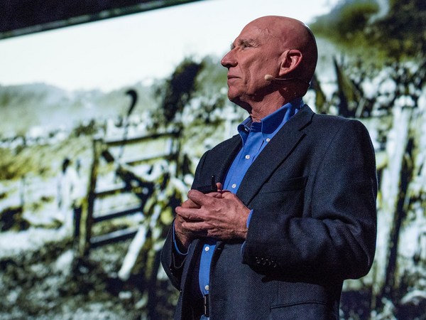
Now I'm a global ecologist and an Earth explorer with a background in physics and chemistry and biology and a lot of other boring subjects, but above all, I'm obsessed with what we don't know about our planet. So I created this, the Carnegie Airborne Observatory, or CAO. It may look like a plane with a fancy paint job, but I packed it with over 1,000 kilos of high-tech sensors, computers, and a very motivated staff of Earth scientists and pilots. Two of our instruments are very unique: one is called an imaging spectrometer that can actually measure the chemical composition of plants as we fly over them. Another one is a set of lasers, very high-powered lasers, that fire out of the bottom of the plane, sweeping across the ecosystem and measuring it at nearly 500,000 times per second in high-resolution 3D. Here's an image of the Golden Gate Bridge in San Francisco, not far from where I live. Although we flew straight over this bridge, we imaged it in 3D, captured its color in just a few seconds. But the real power of the CAO is its ability to capture the actual building blocks of ecosystems. This is a small town in the Amazon, imaged with the CAO. We can slice through our data and see, for example, the 3D structure of the vegetation and the buildings, or we can use the chemical information to actually figure out how fast the plants are growing as we fly over them. The hottest pinks are the fastest-growing plants. And we can see biodiversity in ways that you never could have imagined. This is what a rainforest might look like as you fly over it in a hot air balloon. This is how we see a rainforest, in kaleidoscopic color that tells us that there are many species living with one another. But you have to remember that these trees are literally bigger than whales, and what that means is that they're impossible to understand just by walking on the ground below them. So our imagery is 3D, it's chemical, it's biological, and this tells us not only the species that are living in the canopy, but it tells us a lot of information about the rest of the species that occupy the rainforest.
صنعت جهاز الـ CAO لكي يجيب الأسئلة التي أُثبتت أنها تتحدانا ان نعثر على إجابة من أي وجهة نظر أخرى، مثل كما كنا نبحث في الأرض، أو عن طريق مستشعرات الأقمار الصناعية أريد أن أشارككم بثلاثة من هذه الأسئلة معكم اليوم. السؤال الأول هو، كيف يمكننا إدارة إحتياطي الكربون لدينا في الغابات الاستوائية؟ الغابات الاستوائية تحتوي على الكثير من الكربون بداخل الأشجار، ونحن في حاجة لنحافظ على الكربون بداخل هذه الأشجار إذا كنا في نريد تجنب المزيد من ظاهر الاحتباس الحراري. للأسف، إنباعثات الكربون العالمية الناتجة عن إزالة الغابات تساوي الآن قطاع النقل العالمي. كل السفن، الطائرات، القطارات، والسيارت مجتمعةً. لذلك من المفهوم ان مفاوضي السياسات العامة يعملون جاهدين للحد من إزالة الغابات، ولكنهم يفعلون ذلك على الخرائط فقط كان ذلك بالكاد معروف بالعلوم. إذا لم تكن تعرف أي يكون الكربون بالفعل، وبالتفصيل، كيف تستطيع ان تعرف ما ستفقده؟ في الأساس، نحن في حاجة لنظام محاسبي عالي التقنية. مع النظام الجديد الخاص بنا، استطعنا رؤية مخزون الكربون في الغابات الاستوائية بالتفصيل. اللون الأحمر يظهر، بوضوح، غابة استوائية مظلمة ومغلقة، ومن ثم تستطيع ان ترى الأجزاء المقطوعة، أو القطع من الغابة الملونة باللونين الأصفر والأخضر. تبدو وكأنها كقطع الكعك إلا ان هذه الكعكة تبدو تقريبا بعمق حوت ومع هذا، نستطيع ان تكبير الصورة ورؤية الغابة والأشجار في الوقت نفسه. والعجيب في هذا هو، ومع اننا نطير عاليا جدا فوق هذا الغابة، لاحقا وبعد التحليل، نستطيع التغلغل بالداخل ونرى الأشجار بالفعل ورقة بورقة، وفرع بفرع، بالمثل كما نرى الكائنات الأخرى التي تعيش في هذه الغابة كما لو كنا نعيش بداخل تلك الاشجار نفسها
Now I created the CAO in order to answer questions that have proven extremely challenging to answer from any other vantage point, such as from the ground, or from satellite sensors. I want to share three of those questions with you today. The first questions is, how do we manage our carbon reserves in tropical forests? Tropical forests contain a huge amount of carbon in the trees, and we need to keep that carbon in those forests if we're going to avoid any further global warming. Unfortunately, global carbon emissions from deforestation now equals the global transportation sector. That's all ships, airplanes, trains and automobiles combined. So it's understandable that policy negotiators have been working hard to reduce deforestation, but they're doing it on landscapes that are hardly known to science. If you don't know where the carbon is exactly, in detail, how can you know what you're losing? Basically, we need a high-tech accounting system. With our system, we're able to see the carbon stocks of tropical forests in utter detail. The red shows, obviously, closed-canopy tropical forest, and then you see the cookie cutting, or the cutting of the forest in yellows and greens. It's like cutting a cake except this cake is about whale deep. And yet, we can zoom in and see the forest and the trees at the same time. And what's amazing is, even though we flew very high above this forest, later on in analysis, we can go in and actually experience the treetrops, leaf by leaf, branch by branch, just as the other species that live in this forest experience it along with the trees themselves.
استخدمنا هذه التقنية لكي نستكشف ونستطيع إيجاد المناطق الفعلية التي تحتوي على الكربون ولأول مرة بجودة عالية في أماكن بعيدة مثل حوض الأمازون وأماكن ليست ببعيدة مثل الولايات المتحدة وأمريكا الوسطى. ما أنا بصدد أن أفعله هو أن أخذكم إلى جولتكم ذات الجودة العالية، وللمرة الأولى لاماكن تحتوي على الكربون من بيرو ومن ثم إلى بنما الألوان ستتغير من اللون الأحمر إلى الأزرق الأحمر يعبر عن المناطق التي تحوي الكثير من محزون الفحم، أكبر الغابات اللي من الممكن ان تتخيلها، واللون الأزرق يعبر عن المناطق ذات مخزون قليل من الفحم. ودعوني اخبركم، بيرو واحدة من أكثر الأماكن روعة، ولا نعرفه تماما في ما هي مناطق الكربون التي تحتويها حتى اليوم. نستطيع ان نحلق إلى هذه المنطقة من شمال بيرو ونرى هذه المناطق الغنية بالفخم ذات اللون الأحمر، ونهر الأمازون والسهول الفيضية تحترقها من المنتصف تقريبا. يمكننا ان نذهب إلى منطقة من الخراب التام الناجم عن إزالة الغابات وملونة باللون الأزرق، والمناطق التي سيلحق بها الخراب من إزالة الغابات منتشرة باللون البرتقالي يمكننا أيضا أن نذهب إلى جبال الأنديز لنرى خط الأشجار وكيف بالضبط تنتهي المناطق التي تحتوي على الكربون بيما نصعد على سلسلة الجبال ويمكننا ان نذهب إلى أكبر مستنقع في غرب الأمازون. أنه عالم الأحلام المائي كما شبهه جيم كاميرون بفيلم ".Avatar" نستطيع الذهاب إلى أصغر البلاد الاستوائية، بنما، لنرى أيضا مجموعة مناطق كبيرة من التغييرات الكربونية من الأكثر باللون الأحمر إلى الأقل باللون الأزرق للأسف، فإن معظم الفحم مفقود في الاراضي المنخفضة، ولكن ما تراه هو ما تبقى، من ناحية المناطق الغنية بالفحم باللون الأخضر والأحمر، هيا تلك الأشياء المتروكة في أعالي الجبال. يوجد استثناء واحد مثير للإهتمام هو في منتصف الشاشة ترون المنطقة العازلة حول قناة بنما تلك التي بالألون الحمراء والصفراء تستخدم السلطات المخولة القوة لتحمي مستجمعات المياة والتجارة العالمية هذا النوع من تحديد الأماكن المحتوية على الفحم أدت إلى تطوير سياسة الحفظ والموارد بالفعل ساعدتنا على النهوض بقدرتنا على حماية الغابات والحد من تغير المناخ.
We've been using the technology to explore and to actually put out the first carbon geographies in high resolution in faraway places like the Amazon Basin and not-so-faraway places like the United States and Central America. What I'm going to do is I'm going to take you on a high-resolution, first-time tour of the carbon landscapes of Peru and then Panama. The colors are going to be going from red to blue. Red is extremely high carbon stocks, your largest cathedral forests you can imagine, and blue are very low carbon stocks. And let me tell you, Peru alone is an amazing place, totally unknown in terms of its carbon geography until today. We can fly to this area in northern Peru and see super high carbon stocks in red, and the Amazon River and floodplain cutting right through it. We can go to an area of utter devastation caused by deforestation in blue, and the virus of deforestation spreading out in orange. We can also fly to the southern Andes to see the tree line and see exactly how the carbon geography ends as we go up into the mountain system. And we can go to the biggest swamp in the western Amazon. It's a watery dreamworld akin to Jim Cameron's "Avatar." We can go to one of the smallest tropical countries, Panama, and see also a huge range of carbon variation, from high in red to low in blue. Unfortunately, most of the carbon is lost in the lowlands, but what you see that's left, in terms of high carbon stocks in greens and reds, is the stuff that's up in the mountains. One interesting exception to this is right in the middle of your screen. You're seeing the buffer zone around the Panama Canal. That's in the reds and yellows. The canal authorities are using force to protect their watershed and global commerce. This kind of carbon mapping has transformed conservation and resource policy development. It's really advancing our ability to save forests and to curb climate change.
سؤالي الثاني هو: كيف لنا ان نحد من تغير المناخ في مكان مثل غابة الأمازون الممطرة؟ دعوني اخبركم بهذا، أقضي الكثير من الأوقات في تلك الأماكن، ونرى المناخ وهو يتغير بالفعل. درجات الحرارة ترتفع، وما يحدث حقا هو اننا نشعر بالكثير من الجفاف، موجات متكررة من الجفاف. الجفاف الكبير الذي حدث في العام 2010 يظهر هنا باللون الأحمر يظهر منطقة تقريبا حجمها مثل حجم أوروبا الغربية منطقة الأمازون كانت جافة تماما في العام 2010 حتى الفرع الرئيسي لنهر الأمازون نفسه جف جزئيا، كما ترونه في الصورة في الجزء السفلي من الصورة ما استطعنا ان نصل إليه ان في المناطق النائية جدا، كان للجفاف أثر سلبي كيبر على الغابابت الاستوائية. على سبيل المثال، هذه هى كل الاشجار الميتة والتي باللون الأحمر والتي ماتت بعد الجفاف في عام 2010. وتقع هذه المنطقة على الحدود بين بيرو والبرازيل غير مستكشفة على الاطلاق وتقريبا غير معلومة علمية على الاطلاق.
My second question: How do we prepare for climate change in a place like the Amazon rainforest? Let me tell you, I spend a lot of time in these places, and we're seeing the climate changing already. Temperatures are increasing, and what's really happening is we're getting a lot of droughts, recurring droughts. The 2010 mega-drought is shown here with red showing an area about the size of Western Europe. The Amazon was so dry in 2010 that even the main stem of the Amazon river itself dried up partially, as you see in the photo in the lower portion of the slide. What we found is that in very remote areas, these droughts are having a big negative impact on tropical forests. For example, these are all of the dead trees in red that suffered mortality following the 2010 drought. This area happens to be on the border of Peru and Brazil, totally unexplored, almost totally unknown scientifically.
لذلك ما نتعقده، كعلماء الأرض، ان الكائنات عليها ان تهاجر مع تغير المناخ الحادث في شرق البرازيل على طول الطريق غربا إلى منطقة جبال الانديز ثم إلى أعلى السلسة الجبلية حتى تقلل من تعرضها للتغيرات المناخية احد المشكلات مع هذا ان البشر يحتلون جزء من غرب الأمازون في الوقت الحالي انظروا لهذا الشرخ على مساحة 100 كيلو متر مربع في الغابة من صنع منقبي الذهب ترون الغابة باللون الاخصر في الصورة ثلاثية الابعاد وترون التأثير الناتج من التنقيب عن الذهب تحت سطح التربة من الواضح ان الكائنات ليس لها مكان آخر لتهاجر إليه في هذا النظام البيئي.
So what we think, as Earth scientists, is species are going to have to migrate with climate change from the east in Brazil all the way west into the Andes and up into the mountains in order to minimize their exposure to climate change. One of the problems with this is that humans are taking apart the western Amazon as we speak. Look at this 100-square-kilometer gash in the forest created by gold miners. You see the forest in green in 3D, and you see the effects of gold mining down below the soil surface. Species have nowhere to migrate in a system like this, obviously.
إذا لم تذهب من قبل إلى الأمازون، فإني انصحك بالذهاب فهو مكان رائع يحوي تجربة رائعة كل مرة، بغض النظر عن اينما تذهب وانت على الارجح بصددر ان تراه بهذه الطريقة، على نهر. ولكن ما يحدث اكثر من هذا بكثير النهر يخفي ما يحدث بالفعل داخل الغابة نفسها قمنا بالطيرات على نفس النهر، وقمنا بتصويره صورة ثلاثية الابعاد الغابة على اليسار وعن طريقة التقنيات الرقمية استطعنا ان نزيل الغابة وان نرى ما يحدث تحت الظلال وفي هذه الحالة، وجدنا اعمال التنقيب عن الذهب، وكلها اعمال غير شرعية إلى الوراء من ناحية حافة النهر، كما سترون في تلك البثور الغريبة التي تظهر على الشاشة على اليمين لا تقلقون، نحن نعمل مع السلطات لكي نحل مثل المشكلات، والعديد من المشكلات المختلقة في المنطقة.
If you haven't been to the Amazon, you should go. It's an amazing experience every time, no matter where you go. You're going to probably see it this way, on a river. But what happens is a lot of times the rivers hide what's really going on back in the forest itself. We flew over this same river, imaged the system in 3D. The forest is on the left. And then we can digitally remove the forest and see what's going on below the canopy. And in this case, we found gold mining activity, all of it illegal, set back away from the river's edge, as you'll see in those strange pockmarks coming up on your screen on the right. Don't worry, we're working with the authorities to deal with this and many, many other problems in the region.
لذلك ومن أجل ان نضع معا خطة حفظ لهذه المناطق الهامة، والفريدة من نوعها مثل غرب الأمازون وممر جبال الانديز مع الأمازون يجب ان نبدأ في عمل خطط جغرافيه واضحة المعالم الآن. كيف لنا ان نفعل هذا من دون أن لا نعرف خريطة التنوع البيولوجي في المنطقة، إن كان غير معروف حتى للعلوم؟ لذلك ما قمنا به هو استخدام التحليل الطيفي الموجه بالليزر من جهاز CAO لرسم خريطة التوع البيولوجي للمرة الأولى لغابة الأمازون الممطرة. وهنا ترون البينات الحقيقة والتي تبين الكائنات المختلفة في ألوان مختلفة. اللون الأحمر هو أحد أنواع الكائنات، والأزرق هو الآخر، واللون الأخضر هو نوع ثالث. وعندما نأخذ هذا على مقياس أعلى يصل للمستوى الأقليمي نحصل على خرائط جغرافية جديدة تماماً. من التنوع البيولوجي غير المعروف قبل هذا العمل. وهذا يخبرنا أين التنوع البيولوجي الحادث يحدث من سكن إلى سكن آخر وهذا هام بالفعل لانه يخبرنا الكثير عن اين قد تذهب المخلوقات وتهاجر إلى وتهاجر من طبقا للتغيرات المناخية. وهذه هيا المعلومات المحورية التي يحتاجها صناع القرار لتطوير المناطق المحمية في سياق خطط التطوير المحلية
So in order to put together a conservation plan for these unique, important corridors like the western Amazon and the Andes Amazon corridor, we have to start making geographically explicit plans now. How do we do that if we don't know the geography of biodiversity in the region, if it's so unknown to science? So what we've been doing is using the laser-guided spectroscopy from the CAO to map for the first time the biodiversity of the Amazon rainforest. Here you see actual data showing different species in different colors. Reds are one type of species, blues are another, and greens are yet another. And when we take this together and scale up to the regional level, we get a completely new geography of biodiversity unknown prior to this work. This tells us where the big biodiversity changes occur from habitat to habitat, and that's really important because it tells us a lot about where species may migrate to and migrate from as the climate shifts. And this is the pivotal information that's needed by decision makers to develop protected areas in the context of their regional development plans.
والسؤال الثالث والأخير هو، كيف يمكننا إدارة التنوع البيولوجي على كوكب الأنظمة البيئية المحمية؟ المثال الذي بدأت به الذي كان يتحدث عن كيف يصطاد الأسود، هذه كانت احد الدراسات التي قمنا بها من خلف اسوار منطقة محمية في جنوب افريقيا والحقيقة هيا، معظم طبيعة أفريقيا سوف تستمر إلى المستقبل في المناطق المحمية كما ترونها باللون الأزرق على الشاشة. هذا يضع ضغط كبير ومسئولية على إدارة المحمية الطبيعية. يجب ان يتخذو القرارت التي ستفيد كل الكائنات التي تحميها. بعض من قرارتهم تحدث الكثير من التأثيرات. على سبيل المثال، كم وكيف تستخدم النار كآداة للإدارة؟ أو، كيف تتعامل مع كائن كبير الحجم مثل الفيَلة، والتي من الممكن، اذا ذاد تعدادهم كثيرا، ان تؤثر سلبا في النظام البيئي وعلى الكائنات الأخرى. ودعني أخبركم بهذا، هذه الانواع من التغيرات ثؤثر بالفعل على المشهد العام والخريطة في مقدمة الصورة منطقة مشتعلة بالكثير من النيران والكثير من الفيَلة: سهول السافانا الواسعة باللون الأزرق، والقليل من الأشجار. واستطعنا ان نخترق هذا الحد، والآن قد دخلنا إلى منطقة محمية من النيران وليس بها أفيَلة: نباتات كثيفة، نظام بيئي مختلف جذريا. وفي مكان مثل كروجر، ارتفاع اعداد الأفيَلة هيا مشكلة حقيقة. اعرف ان هذا امر حساس للكثير منكم، وليس له إجابة سهلة مع ذلك. ولكن ما هو جيدا ان التقنية التي قمنا بتطويرها ونحن نعمل في جنوب افريقيا، على سبيل المثال، سمحت لنا برسم خريطة لكل شجرة على حدة في سهول السافانا، وبعد ذلك وعن طريق تكرار الرحلات استطعنا ان نرى اي من الاشجار التي تحطم عن طريق الفيَلة، باللون الأحمر كما نرى على الشاشة، وكم مرة يحدث ذلك في أماكن مختلفة من سهول السافانا هذه البيانات تعطي مديري المحمية الطبيعية ولأول مرة الفرصة لاستخدام استراتيجيات الإدارة التكتيكية والتي تعد أكثر دقة ولا تؤدي إلى تلك النهايات التي عرضتها عليكم للتو. لذلك بالفعل، الطريقة التي ننظر بها إلى الأماكن المحمية في هذه الأيام هو التفكير في الامر الذي ستستمر عليه دورة الحياة، حيث لدينا الإدارة بالنار، تنظيم قطيع الفيَلة، هذه التأثيرات على بنية النظام البيئي وبعدها هذه التأثيرات ستوثر على كل شيء من الحشرات وحتى قمة الحيوانات المفترسة مثل الأسود.
And third and final question is, how do we manage biodiversity on a planet of protected ecosystems? The example I started out with about lions hunting, that was a study we did behind the fence line of a protected area in South Africa. And the truth is, much of Africa's nature is going to persist into the future in protected areas like I show in blue on the screen. This puts incredible pressure and responsibility on park management. They need to do and make decisions that will benefit all of the species that they're protecting. Some of their decisions have really big impacts. For example, how much and where to use fire as a management tool? Or, how to deal with a large species like elephants, which may, if their populations get too large, have a negative impact on the ecosystem and on other species. And let me tell you, these types of dynamics really play out on the landscape. In the foreground is an area with lots of fire and lots of elephants: wide open savanna in blue, and just a few trees. As we cross this fence line, now we're getting into an area that has had protection from fire and zero elephants: dense vegetation, a radically different ecosystem. And in a place like Kruger, the soaring elephant densities are a real problem. I know it's a sensitive issue for many of you, and there are no easy answers with this. But what's good is that the technology we've developed and we're working with in South Africa, for example, is allowing us to map every single tree in the savanna, and then through repeat flights we're able to see which trees are being pushed over by elephants, in the red as you see on the screen, and how much that's happening in different types of landscapes in the savanna. That's giving park managers a very first opportunity to use tactical management strategies that are more nuanced and don't lead to those extremes that I just showed you. So really, the way we're looking at protected areas nowadays is to think of it as tending to a circle of life, where we have fire management, elephant management, those impacts on the structure of the ecosystem, and then those impacts affecting everything from insects up to apex predators like lions.
ذهابا للأمام، أخطط لكل أوسع المرصد الطائر. أتمنى ان أضع التقنية في قمر صناعي لكي نستيطع إدارة الكوكب بأكلمه بمثل هذه التقنيات وحتى هذا الحين ستجودني طائراً في بعض الأماكن البعيدة التي لم تسمعوا عنها من قبل. اريد أن أنهي بأن أقول ان هذه التقنية هي في غاية الاهمية لإدارة كوكبنا وحتى الأكثر أهمية الفهم والحكمة لتطبيقها
Going forward, I plan to greatly expand the airborne observatory. I'm hoping to actually put the technology into orbit so we can manage the entire planet with technologies like this. Until then, you're going to find me flying in some remote place that you've never heard of. I just want to end by saying that technology is absolutely critical to managing our planet, but even more important is the understanding and wisdom to apply it.
شكرا لكم.
Thank you.
(تصفيق)
(Applause)