So how many of you have ever been in a cave before? Okay, a few of you. When you think of a cave, most of you think of a tunnel going through solid rock, and in fact, that's how most caves are. Around this half of the country, most of your caves are made of limestone. Back where I'm from, most of our caves are made of lava rock, because we have a lot of volcanoes out there. But the caves I want to share with you today are made completely of ice, specifically glacier ice that's formed in the side of the tallest mountain in the state of Oregon, called Mount Hood.
Wie van jullie is al eens in een grot geweest? Oké, weinig. De meesten denken bij een grot aan een tunnel door massieve rots, en dat is het meestal ook. In dit gedeelte van het land, zijn de meeste grotten van kalksteen. Maar waar ik vandaan kom, zijn de meeste van lavasteen, omdat daar veel vulkanen zijn. De grotten die ik je nu wil laten zien zijn helemaal van ijs, speciaal gletsjerijs dat is ontstaan op de grootste berg van de staat Oregon: Mount Hood.
Now Mount Hood's only one hour's drive from Portland, the largest city in Oregon, where over two million people live. Now the most exciting thing for a cave explorer is to find a new cave and be the first human to ever go into it. The second most exciting thing for a cave explorer is to be the first one to make a map of a cave. Now these days, with so many people hiking around, it's pretty hard to find a new cave, so you can imagine how excited we were to find three new caves within sight of Oregon's largest city and realize that they had never been explored or mapped before. It was kind of like being an astronaut, because we were getting to see things and go places that no one had ever seen or gone to before.
Mount Hood is maar een uur rijden vanaf Portland, de grootste stad van Oregon, waar meer dan twee miljoen mensen wonen. Het spannendste voor een grotonderzoeker is het vinden van een nieuwe grot en de eerste mens te zijn die naar binnen gaat. Het een na spannendste voor de grotonderzoeker is als eerste de kaart maken van de grot. Het is tegenwoordig, met al die buitensporters, erg moeilijk om een nieuwe grot te vinden. Je snapt hoe opgewonden wij waren toen we drie nieuwe grotten vonden dichtbij de grootste stad van Oregon en beseften dat ze onontdekt waren en nog niet in kaart gebracht. Het was zoiets als een astronaut die ergens naartoe gaat waar nog nooit iemand is geweest.
So what is a glacier? Well, those of you who have ever seen or touched snow, you know that it's really light, because it's just a bunch of tiny ice crystals clumped together, and it's mostly air. If you squish a handful of snow to make a snowball, it gets really small, hard and dense. Well, on a mountain like Hood, where it snows over 20 feet a year, it crushes the air out of it and gradually forms it into hard blue ice. Now each year, more and more ice stacks up on top of it, and eventually it gets so heavy that it starts to slide down the mountain under its own weight, forming a slow-moving river of ice. When ice packed like that starts to move, we call it a glacier, and we give it a name. The name of the glacier these caves are formed in is the Sandy Glacier. Now each year, as new snow lands on the glacier, it melts in the summer sun, and it forms little rivers of water on the flow along the ice, and they start to melt and bore their way down through the glacier, forming big networks of caves, sometimes going all the way down to the underlying bedrock. Now the crazy thing about glacier caves is that each year, new tunnels form. Different waterfalls pop up or move around from place to place inside the cave. Warm water from the top of the ice is boring its way down, and warm air from below the mountain actually rises up, gets into the cave, and melts the ceilings back taller and taller. But the weirdest thing about glacier caves is that the entire cave is moving, because it's formed inside a block of ice the size of a small city that's slowly sliding down the mountain.
Wat is nou een gletsjer? Iedereen die wel eens sneeuw heeft aangeraakt, weet dat het heel licht is. Het zijn ijskristallen die samengeklonterd zijn, maar vooral lucht. Als je wat samenknijpt om een sneeuwbal te maken, wordt het heel klein en hard. Op een berg als Hood, met meer dan 7 meter sneeuw per jaar, wordt de lucht eruit gedrukt en wordt dan langzaam hard blauw ijs. Elk jaar stapelt zich meer ijs op, en uiteindelijk is het zo zwaar dat het naar beneden gaat schuiven door zijn eigen gewicht, en een traagstromende ijsrivier vormt. Als zulk ijs gaat bewegen, noemen we het een gletsjer en krijgt het een naam. Deze grotten bevinden zich in Sandy Glacier. Deze grotten bevinden zich in Sandy Glacier. Elk jaar daalt sneeuw neer op de gletsjer en smelt in de zomerzon. Er vormen zich stroompjes water die langs het ijs lopen. Ze smelten en boren zich een weg door de gletsjer, en maken zo een netwerk van grotten. Soms helemaal tot de rotsbodem onder de gletsjer. Het gekke is dat er elk jaar nieuwe tunnels worden gevormd. Watervallen verschijnen plotseling ergens anders in de grot. Warm water op het ijs boort zich naar beneden, en warme lucht vanuit het dal komt in de grot terecht, en maakt hem steeds groter. Maar het gekste is dat de hele grot beweegt omdat hij in een blok ijs zit zo groot als een kleine stad die langzaam bergaf glijdt. Dit is Brent McGregor,
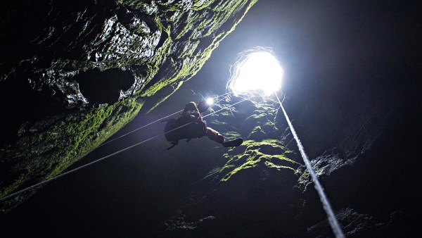
Now this is Brent McGregor, my cave exploration partner. He and I have both been exploring caves a long time and we've been climbing mountains a long time, but neither one of us had ever really explored a glacier cave before. Back in 2011, Brent saw a YouTube video of a couple of hikers that stumbled across the entrance to one of these caves. There were no GPS coordinates for it, and all we knew was that it was somewhere out on the Sandy Glacier. So in July of that year, we went out on the glacier, and we found a big crack in the ice. We had to build snow and ice anchors so that we could tie off ropes and rappel down into the hole. This is me looking into the entrance crevasse. At the end of this hole, we found a huge tunnel going right up the mountain underneath thousands of tons of glacier ice. We followed this cave back for about a half mile until it came to an end, and then with the help of our survey tools we made a three-dimensional map of the cave on our way back out.
mijn grotonderzoekpartner. Wij onderzoeken al lang grotten en hebben al veel samen geklommen, maar geen van ons had ooit een gletsjergrot onderzocht. In 2011 zag Brent een video op YouTube van mensen die langs de ingang van deze grotten liepen. Er waren geen GPS-coördinaten van. We wisten alleen dat het ergens op de Sandy Glacier was. In juli van dat jaar gingen we naar de gletsjer, en ontdekten een grote scheur in het ijs. We moesten sneeuw- en ijsankers maken zodat we met touwen konden afdalen in het gat. Ik kijk hier in de ingang van de spleet. Aan het eind van het gat vonden we een enorme tunnel die recht bij de berg omhoog ging, onder duizenden tonnen gletsjerijs door. We volgden deze grot 800 meter lang tot het einde. Met onze onderzoekspullen maakten we een 3D-kaart van de grot, en gingen terug.
So how do you map a cave? Well, cave maps aren't like trail maps or road maps because they have pits and holes going to overlapping levels. To make a cave map, you have to set up survey stations every few feet inside the cave, and you use a laser to measure the distance between those stations. Then you use a compass and an inclinometer to measure the direction the cave is headed and measure the slope of the floor and the ceilings. Now those of you taking trigonometry, that particular type of math is very useful for making maps like this because it allows you to measure heights and distances without actually having to go there. In fact, the more I mapped and studied caves, the more useful I found all that math that I originally hated in school to be. So when you're done surveying, you take all this data and you punch it into a computer and you find someone that can draw really well, and you have them draft up a map that looks something like this, and it'll show you both a bird's-eye view of the passage as well as a profile view of the passage, kind of like an ant farm view. We named this cave Snow Dragon Cave because it was like a big dragon sleeping under the snow. Now later this summer, as more snow melted off the glacier, we found more caves, and we realized they were all connected.
Hoe maak je eigenlijk zo'n kaart? Rotskaarten zijn anders dan wegenkaarten omdat ze kuilen hebben en overlappende niveaus. Om een grotkaart te maken, moet je elke paar meter een markering neerzetten, en meet je met laser de afstand tussen die markeringen. Dan pak je je kompas en hoekmeter en meet de richting waar de grot naartoe loopt en de helling van de vloer en de plafonds. Wie van jullie driehoeksmeting heeft gehad, snapt dat het hier heel handig voor is, omdat je dan hoogtes en afstanden kunt meten van plekken waar je niet kan komen. Hoe meer kaarten ik maakte van grotten, hoe nuttiger ik wiskunde ging vinden terwijl ik het op school altijd haatte. Als je onderzoek doet, stop je al deze gegevens in de computer en zoek je iemand die goed kan tekenen, en dan krijg je zoiets al dit. Het laat de doorgang vanuit vogelperspectief zien maar ook een bovenaanzicht van de doorgang een beetje alsof je naar een mierennest kijkt. We noemden deze grot Snow Dragon omdat het op een grote draak leek die onder de sneeuw lag te slapen. Later in deze zomer, toen er meer sneeuw was gesmolten, vonden we meer grotten en ontdekten dat ze onderling waren verbonden. Kort nadat we een kaart van Snow Dragon maakten,
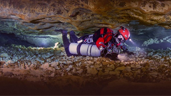
Not long after we mapped Snow Dragon, Brent discovered this new cave not very far away. The inside of it was coated with ice, so we had to wear big spikes on our feet called crampons so we could walk around without slipping. This cave was amazing. The ice in the ceiling was glowing blue anad green because the sunlight from far above was shining through the ice and lighting it all up. And we couldn't understand why this cave was so much colder than Snow Dragon until we got to the end and we found out why. There was a huge pit or shaft called a moulin going 130 feet straight up to the surface of the glacier. Cold air from the top of the mountain was flowing down this hole and blasting through the cave, freezing everything inside of it. And we were so excited about finding this new pit, we actually came back in January the following year so we could be the first ones to explore it. It was so cold outside, we actually had to sleep inside the cave. There's our camp on the left side of this entrance room. The next morning, we climbed out of the cave and hiked all the way to the top of the glacier, where we finally rigged and rappelled this pit for the very first time. Brent named this cave Pure Imagination, I think because the beautiful sights we saw in there were beyond what we could have ever imagined.
ontdekte Brent deze nieuwe grot. De binnenkant was bedekt met ijs. We moesten stijgijzers dragen onder onze voeten. Daarmee konden we rondwandelen zonder uit te glijden. Deze grot was geweldig. Het ijs van het plafond gloeide blauw en groen op omdat het zonlicht erboven door het ijs scheen en de hele boel oplichtte. We begrepen niet waarom deze grot veel kouder was dan Snow Dragon totdat we aan het eind kwamen en het ontdekten. Er was een grote put of schacht, ook wel moulin genoemd die 40 meter omhoog liep naar het oppervlak van de gletsjer. Koude lucht vanaf de top van de berg stroomde in het gat en blies door de grot, en bevroor alles. We waren zo opgewonden over deze ontdekking, dat we een jaar later in januari terugkwamen. Zo konden we het als eersten onderzoeken. Het was zo koud buiten, dat we wel in de grot moesten slapen. Ons kamp is daar links van de ingang. De volgende morgen klommen we uit de grot en liepen helemaal naar de top van de gletsjer, waar we eindelijk voor het eerst deze put abseilden. Brent noemde deze grot 'Pure Imagination', ik denk vanwege de mooie dingen die we er zagen. en die ons voorstellingsvermogen te boven gingen. Wat is er nog meer behalve dit koude ijs?
So besides really cool ice, what else is inside these caves? Well not too much lives in them because they're so cold and the entrance is actually covered up with snow for about eight months of the year. But there are some really cool things in there. There's weird bacteria living in the water that actually eat and digest rocks to make their own food to live under this ice. In fact, this past summer, scientists collected samples of water and ice specifically to see if things called extremophiles, tiny lifeforms that are evolved to live in completely hostile conditions, might be living under the ice, kind of like what they hope to find on the polar icecaps of Mars someday. Another really cool things is that, as seeds and birds land on the surface of the glacier and die, they get buried in the snow and gradually become part of the glacier, sinking deeper and deeper into the ice. As these caves form and melt their way up into the ice, they make these artifacts rain down from the ceiling and fall onto the cave floor, where we end up finding them. For example, this is a noble fir seed we found. It's been frozen in the ice for over 100 years, and it's just now starting to sprout. This mallard duck feather was found over 1,800 feet in the back of Snow Dragon Cave. This duck died on the surface of the glacier long, long ago, and its feathers have finally made it down through over 100 feet of ice before falling inside the cave. And this beautiful quartz crystal was also found in the back of Snow Dragon.
Nou, niet veel leven omdat het er zo koud is en de ingang acht maanden per jaar bedekt is met sneeuw. Maar er zijn wel een paar erg mooie dingen. Er leven vreemde bacteriën in het water die rots eten en verteren zodat ze onder het ijs kunnen leven. Afgelopen zomer verzamelden wetenschappers monsters van water en ijs om te zien of er kleine levensvormen als extremophiles leefden volledig afgezonderd, onder het ijs. Die we ook hopen te vinden op de poolkappen van Mars. Nog iets anders: zaden en vogels landen op de gletsjer en gaan dood, ze worden begraven door de sneeuw en worden langzaam onderdeel van de gletsjer. Ze zakken dieper en dieper weg in het ijs. Terwijl de grotten zich vormen en omhoog smelten door het ijs, komen voorwerpen los van het plafond en druppelen naar beneden Ze vallen op de vloer van de grot, waar we ze uiteindelijk vinden. Dit is bijvoorbeeld een sparrenzaadje dat we vonden. Het is meer dan 100 jaar bevroren geweest. Het begint net te ontkiemen. Deze veer van een wilde eend is 600 meter diep in de Snow Dragongrot gevonden. De eend is lang geleden doodgegaan op de gletsjer, en zijn veren zijn door het 30 meter dikke ijs gezakt voordat hij in de grot viel. Deze prachtige kwartskristal is ook gevonden in de Snow Dragon.
Even now, Brent and I find it hard to believe that all these discoveries were essentially in our own backyard, hidden away, just waiting to be found. Like I said earlier, the idea of discovering in this busy world we live in kind of seems like something you can only do with space travel now, but that's not true. Every year, new caves get discovered that no one has ever been in before. So it's actually not too late for one of you to become a discoverer yourself. You just have to be willing to look and go where people don't often go and focus your eyes and your mind to recognize the discovery when you see it, because it might be in your own backyard.
Zelfs nu nog snappen Brent en ik niet dat al deze ontdekkingen in onze achtertuin lagen, verstopt, voordat we ze vonden. Dus het idee dat ontdekken in deze drukke wereld alleen met een ruimtereis mogelijk is, is niet waar. Elk jaar worden nieuwe grotten ontdekt die nog nooit iemand heeft gezien. Het is dus nog niet te laat voor jullie om zelf ontdekkingsreiziger te worden. Je moet alleen naar plekken willen gaan waar mensen niet vaak naartoe gaan en je ogen en gedachten richten op het ontdekken omdat het best wel eens in je achtertuin kan zijn.
Thank you very much.
Dank je wel.
(Applause)
(Applaus)