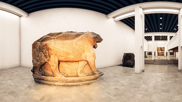
I'd like to start with a short story. It's about a little boy whose father was a history buff and who used to take him by the hand to visit the ruins of an ancient metropolis on the outskirts of their camp. They would always stop by to visit these huge winged bulls that used to guard the gates of that ancient metropolis, and the boy used to be scared of these winged bulls, but at the same time they excited him. And the dad used to use those bulls to tell the boy stories about that civilization and their work.
짧은 이야기로 시작를 하나 드리지요. 역사광인 아버지의 손을 잡고 그들의 캠프 가장자리에 있는 고대 대도시의 폐허를 방문하던 한 소년에 대한 이야기입니다 그들은 종종 그 고대 도시의 입구를 지키던 거대한 날개가 달린 황소들을 보려고 들렀었고, 그 소년은 날개가 달린 황소들이 무서웠지만, 신이 나가도 했지요. 그리고 그 소년의 아버지는 그 황소들을 통해 그곳의 문명과 그들의 업적을 아들에게 이야기 해주곤 했지요.
Let's fast-forward to the San Francisco Bay Area many decades later, where I started a technology company that brought the world its first 3D laser scanning system. Let me show you how it works. Female Voice: Long range laser scanning by sending out a pulse that's a laser beam of light. The system measures the beam's time of flight, recording the time it takes for the light to hit a surface and make its return. With two mirrors, the scanner calculates the beam's horizontal and vertical angles, giving accurate x, y, and z coordinates. The point is then recorded into a 3D visualization program. All of this happens in seconds. Ben Kacyra: You can see here, these systems are extremely fast. They collect millions of points at a time with very high accuracy and very high resolution. A surveyor with traditional survey tools would be hard-pressed to produce maybe 500 points in a whole day. These babies would be producing something like ten thousand points a second. So, as you can imagine, this was a paradigm shift in the survey and construction as well as in reality capture industry.
이제 수십년을 건너 뛰어 제가 샌프란시스코만에 기술회사를 설립해서 세계 최초의 3D 레이저 스캐닝 시스템을 소개했던 당시로 가죠. 그 시스템의 작동원리를 말씀드리죠. 여자 목소리: 이것은 레이저 빔 펄스를 사용해서 장거리 레이저 스캐닝을 하는 시스템입니다. 이 시스템은 레이저 빔이 표적의 표면에 도착한 후 반사되어 되돌아 오는 시간을 측정합니다. 이 시스템은 또한 두개의 거울로 레이저 빔의 수평, 수직 각도를 계산해서, 정확한 x, y, z 좌표를 산출하고 산출된 좌표를 3D 시각화 프로그램에 입력하지요. 이 모든 작업은 수 초 밖에 안걸리지요. BK: 여러분이 여기서 보시는 바와같이 이 시스템은 엄청나게 빠릅니다 이 시스템은 한번에 수백만개의 좌표를 고도의 정확도와 해상도로 포착합니다. 측량사가 재래식 방법으로 측량점을 잰다면 하루에 500개의 점을 측량하기도 힘들겁니다. 저희들의 시스템은 일초에 약 1만개 정도의 점을 포착할 수 있지요. 그래서, 여러분이 짐작하실 수 있겠지만 저희 시스템은 실물포착업계 뿐만아니라 측량과 건설업계에게도 엄청난 발전을 가져왔었지요.
Approximately ten years ago, my wife and I started a foundation to do good, and right about that time, the magnificent Bamiyan Buddhas, hundred and eighty foot tall in Afghanistan, were blown up by the Taliban. They were gone in an instant. And unfortunately, there was no detailed documentation of these Buddhas. This clearly devastated me, and I couldn't help but wonder about the fate of my old friends, the winged bulls, and the fate of the many, many heritage sites all over the world. Both my wife and I were so touched by this that we decided to expand the mission of our foundation to include digital heritage preservation of world sites. We called the project CyArk, which stands for Cyber Archive.
약 10년전에 제 부인과 저는 유익한 일을 하기 위해 재단을 설립했었는데 바로 그때쯤 아프가니스탄에 있는 180 피트의 장대한 바미얀 대불상이 탈레반의 공격으로 파괴되었지요. 순식간에 사라졌었죠 그리고 불행히도 이 불상들에 대한 자세한 기록이 하나도 없었습니다. 이 사건은 저를 충격에 빠트렸고, 저는 소년 시절의 제 친구였던 날개 달린 황소와 전세계에 있는 많은 유적들에 대해 걱정을 하지 않을 수 없었지요. 저와 제 아내는 이 사건을 통해 큰 충격을 받고 저희 재단의 목적 범위를 넓혀 세계 유적지를 디지털 방식으로 보존하는 일도 포함시키기로 결정했지요. 우리는 그 프로젝트를 CyArk라고 부르는데 Cyber Archive(사이버 보관)를 줄여서 만든 말이죠.
To date, with the help of a global network of partners, we've completed close to fifty projects. Let me show you some of them: Chichen Itza, Rapa Nui -- and what you're seeing here are the cloud of points -- Babylon, Rosslyn Chapel, Pompeii, and our latest project, Mt. Rushmore, which happened to be one of our most challenging projects. As you see here, we had to develop a special rig to bring the scanner up close and personal. The results of our work in the field are used to produce media and deliverables to be used by conservators and researchers. We also produce media for dissemination to the public -- free through the CyArk website. These would be used for education, cultural tourism, etc.
저희들은 전 세계에 걸쳐 있는 파트너들의 도움을 받아 지금까지 50개에 가까운 프로젝트를 완료했습니다. 그 중 일부를 보여드리지요. 치첸이트사 라파누이 여러분이 지금 보시는 것은 수없이 많은 좌표들입니다. 바빌론 로슬린 채플 폼페이 그리고 가장 최신 프로젝트였던 러시모어산 프로젝트였는데 지금까지 했던 프로젝트중 가장 힘든것의 하나였죠. 여기서 보시다시피, 저희는 스캐너를 얼굴상의 바로 옆에 설치하기 위해 특별히 리그를 만들어야 했지요. 저희들이 야외에서 포착한 자료는 유물보존 전문가나 연구원들이 그대로 직접사용하거나, 또는 매개물로 사용할 수 있습니다. 저희들은 또한 대중을 상대로 하는 보도자료도 만드는데 이러한 자료는 CyArk 웹사이트에서 무료로 제공합니다. 여기서 제공되는 자료는 교육, 관광 등의 목적으로 사용될 수 있습니다.
What you're looking at in here is a 3D viewer that we developed that would allow the display and manipulation of [the] cloud of points in real time, cutting sections through them and extracting dimensions. This happens to be the cloud of points for Tikal. In here you see a traditional 2D architectural engineering drawing that's used for preservation, and of course we tell the stories through fly-throughs. And here, this is a fly-through the cloud of points of Tikal, and here you see it rendered and photo-textured with the photography that we take of the site. And so this is not a video. This is actual 3D points with two to three millimeter accuracy. And of course the data can be used to develop 3D models that are very accurate and very detailed. And here you're looking at a model that's extracted from the cloud of points for Stirling Castle. It's used for studies, for visualization, as well as for education.
여기에 보시는 것은 저희들이 개발한 3D 뷰어인데 이 뷰어는 스캐너로 포착된 수많은 점들을 실시간에 계산하여 스캔하는 물체의 단면도를 만든 후 그로부터 3차원의 이미지를 만듭니다. 이것은 티칼에서 측정한 점들입니다. 이것은 보존용으로 사용되는 전통적인 2D 설계도면이고 저희들은 물론 가상공간 비행기술을 통해 해당 유적지를 보여드릴 수도 있지요. 이것은 티칼에서 포착한 수많은 점들과 저희들이 현지에서 찍은 사진들을 합성시켜서 사진처럼 보이게 만든 가상공간을 비행하는 것입니다. 즉, 이건 비디오로 찍은게 아니고 2~3mm의 정확도로 측정된 실제 3D 점들이지요. 그리고 그 정보는 아주 정확하고 섬세한 3D 모형을 만드는 데 사용될 수 있습니다 이 모델은 스털링 카슬에서 포착한 수많은 점들로 부터 만든 것이지요. 이것은 교육뿐만 아니라 연구나 시각화 용도로도 사용됩니다.
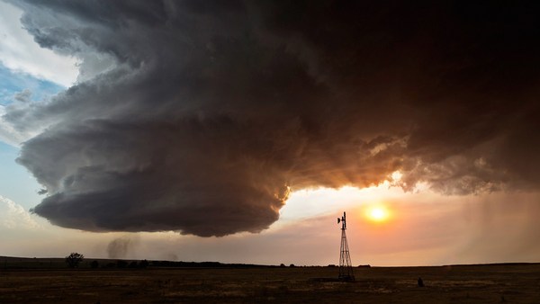
And finally, we produce mobile apps that include narrated virtual tools. The more I got involved in the heritage field, the more it became clear to me that we are losing the sites and the stories faster than we can physically preserve them. Of course, earthquakes and all the natural phenomena -- floods, tornadoes, etc. -- take their toll. However, what occurred to me was human-caused destruction, which was not only causing a significant portion of the destruction, but actually it was accelerating. This includes arson, urban sprawl, acid rain, not to mention terrorism and wars. It was getting more and more apparent that we're fighting a losing battle. We're losing our sites and the stories, and basically we're losing a piece -- and a significant piece -- of our collective memory. Imagine us as a human race not knowing where we came from.
마지막으로, 저희는 내레이션 가상 도구가 포함된 모바일 앱도 만들었습니다 제가 유적지에 관련된 일을 많이하면 할 수록 저는 우리가 유적지를 물리적으로 보존하는 속도가 그것이 파괴되는 속도를 따라가지 못한다는 사실을 절실히 느끼게 됐지요. 물론 지진이나 홍수, 토네이도 같은 자연적인 재해도 유적지를 파손시키지요. 그런데 저는 인간이 만든 재해가 문화재를 붕괴 시키는데 큰 역할을 할뿐만 아니라 붕괴되는 속도가 가속되고 있다는 것을 깨닫게 되었지요. 테러나 전쟁은 말할 필요도 없고, 방화나 도시의 무질서한 확장, 산성비도 붕괴의 원인이 되죠. 날이 갈 수록 우리가 패배할 것이 뻔한 싸움을 하고 있다는 것을 느꼈지요. 우리는 유적과 과거에 대한 물적 유산과 이야기를 잃고 있는데 이것은 즉 우리가 인류의 집합적인 기억의 중요한 일부를 잃고 있다는 것을 의미하지요. 우리의 과거를 모르는 인간이 된다는 것을 생각해보십시오.
Luckily, in the last two or three decades, digital technologies have been developing that have helped us to develop tools that we've brought to bear in the digital preservation, in our digital preservation war. This includes, for example, the 3D laser scanning systems, ever more powerful personal computers, 3D graphics, high-definition digital photography, not to mention the Internet. Because of this accelerated pace of destruction, it became clear to us that we needed to challenge ourselves and our partners to accelerate our work. And we created a project we call the CyArk 500 Challenge -- and that is to digitally preserve 500 World Heritage Sites in five years.
다행히도, 지난 20-30년 동안의 디지털 기술 발전은 우리들이 디지털 보존 전쟁에 사용할 수 있는 도구들을 만들 수 있게 했지요. 예를 들자면, 인터넷은 두 말 할 것도 없고, 3D 레이저 스캐닝 시스템, 날로 발달하는 고성능 PC, 3D 그래픽, HD 디지털 사진 기술 등이 있지요. 유적이 붕괴되는 속도가 빨라짐에 따라 작업 속도를 늘리기 위해 저희들과 저희 파트너에게 채찍을 가해야 한다는 것이 분명해 졌지요. 그래서 저희는 "CyArk 500 챌린지"라는 프로젝트를 시작해서 500개의 세계문화유산을 디지털 방식으로 보존하기로 했지요.
We do have the technology that's scaleable, and our network of global partners has been expanding and can be expanded at a rapid rate, so we're comfortable that this task can be accomplished. However, to me, the 500 is really just the first 500. In order to sustain our work into the future, we use technology centers where we partner with local universities and colleges to take the technology to them, whereby they then can help us with digital preservation of their heritage sites, and at the same time, it gives them the technology to benefit from in the future.
저희는 확장성있는 기술을 가지고 있고, 전 세계에 퍼져있는 저희 조력자들의 수는 이미 늘고 있고 또 급속도로 늘릴 수 있기 때문에 저희는 이 프로젝트를 성공적으로 달성할 수 있다는 자신이 있습니다. 하지만 저에 관한 한 500이라는 숫자는 시작에 불과합니다. 저희들은 또한 앞으로도 디지털 보존 작업을 계속할 수 있도록 곳곳에 있는기술센터를 통해 그 지역에 있는 대학 파트너들이 그들의 지역의 문화유산을 디지털 형식으로 보존하는 일을 도와주는 동시에 그들이 기술 이전 혜택을 받을 수 있게 합니다.
Let me close with another short story. Two years ago, we were approached by a partner of ours to digitally preserve an important heritage site, a UNESCO heritage site in Uganda, the Royal Kasubi Tombs. The work was done successfully in the field, and the data was archived and publicly disseminated through the CyArk website. Last March, we received very sad news. The Royal Tombs had been destroyed by suspected arson. A few days later, we received a call: "Is the data available and can it be used for reconstruction?" Our answer, of course, was yes.
제 강연을 끝내기 전에 짧은 이야기를 하나 말씀드리죠. 2년 전에 저희 파트너의 하나가 우간다에 있는 UNESCO 문화 유산인 카수비 왕릉을 디지털 매체로 보존해 달라는 요청을 받았었지요. 저희들은 그 프로젝트를 성공적으로 끝낸 후 데이터를 보존하고 CyArk 웹사이트를 통해 일반인에게 그 자료를 공개했죠. 그런데 지난 3월에 우리는 방화로 의심되는 사건으로 왕릉이 소실됐다는 매우 슬픈 뉴스를 받았었지요. 그리고 몇일 후에 저희들은 왕릉을 재건하는데 우리가 보존하고 있는 데이터를 사용할 수 있냐는 전화를 받았지요. 물론 저희의 대답은 "네"였습니다
Let me leave you with a final thought. Our heritage is much more than our collective memory -- it's our collective treasure. We owe it to our children, our grandchildren and the generations we will never meet to keep it safe and to pass it along. Thank you.
마지막으로 한 마디만 더 드리죠. 우리의 문화 유적지들은 우리의 집단 기억일 뿐만 아니라 우리의 집합적인 재산입니다. 우리는 우리의 자식, 손자 손녀, 그리고 아직 태어나지 않은 후손들을 위해 문화유산을 안전하게 보존하고 물려줄 의무가 있습니다. 감사합니다
(Applause) Thank you.
(박수) 감사합니다
Thank you.
감사합니다
Thank you.
감사합니다
Well, I'm staying here because we wanted to demonstrate to you the power of this technology and so, while I've been speaking, you have been scanned. (Laughter) The two wizards that I have that are behind the curtain will help me bring the results on the screen. (Applause)
제가 아직도 여기에 서있는 이유는 이 기술의 파워를 여러분께 보여드리기 위해 제가 강연을 하는 동안 여러분이들 스캔 당하셨습니다 (웃음) 이 커튼 뒤에 있는 두 명의 마법사들이 결과물을 스크린에 보여주도록 도와주실 겁니다. (박수)
This is all in 3D and of course you can fly through the cloud of points. You can look at it from on top, from the ceiling. You can look from different vantage points, but I'm going to ask Doug to zoom in on an individual in the crowd, just to show the amount of detail that we can create. So you have been digitally preserved in about four minutes. (Laughter)
이 영상은 전부 3D인데 여러분들은 이 점들의 가상공간을 날라 다닐 수 있습니다. 이 강의실 꼭대기, 천장에서도 볼 수 있습니다 그리고 다른 시점에서도 볼 수 있지만, 저는 우리 시스템의 해상도가 어느 정도인지 보여드리기 위해 저의 동료인 더그에게 여러분중의 한분에게 줌 인하라고 부탁하겠습니다. 그러니까 여러분들께서는 약 4분간 디지털로 보존된 셈입니다. (웃음)
I'd like to thank the wizards here. We were very lucky to have two of our partners participate in this: the Historic Scotland, and the Glasgow School of Art. I'd like to also thank personally the efforts of David Mitchell, who is the Director of Conservation at Historic Scotland. David. (Applause) And Doug Pritchard, who's the Head of Visualization at the Glasgow School of Art. Let's give them a hand.
여기에 계신 마법사들에게 감사드리고 저희의 파트너인 스코틀랜드의 문화재 관리국인 히스토릭 스코틀랜드와 글라스고 미술대학이 이 자리에 참석해 주셔서 매우 행운이라고 생각합니다. 그리고 히스토릭 스코틀랜드의 문화재 보존 이사인 데이비드 미첼의 노고에 개인적으로 감사드립니다. 데이비드 (박수) 그리고 글래스고 미술 대학의 시각화 과장인 더그 피처드에게도 감사드립니다 박수 부탁드립니다
(Applause)
(박수)
Thank you.
감사합니다