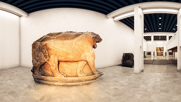
I'd like to start with a short story. It's about a little boy whose father was a history buff and who used to take him by the hand to visit the ruins of an ancient metropolis on the outskirts of their camp. They would always stop by to visit these huge winged bulls that used to guard the gates of that ancient metropolis, and the boy used to be scared of these winged bulls, but at the same time they excited him. And the dad used to use those bulls to tell the boy stories about that civilization and their work.
הייתי רוצה להתחיל עם סיפור קצר. הוא על ילד קטן שאביו היה אוהב היסטוריה ושהיה לוקח אותו ביד לבקר חורבות עיר עתיקה בקצה המחנה שלהם. הם תמיד היו עוצרים לבקר את הפרים המכונפים הענקיים האלה שהיו שומרים על שעריה של העיר העתיקה הזו, והילד היה מפחד מהפרים המכונפים האלה, אבל באותו זמן הם ריגשו אותו. והאב היה משתמש בפרים האלה כדי לספר לילד סיפורים על הציויליזציה ההיא ופועלה.
Let's fast-forward to the San Francisco Bay Area many decades later, where I started a technology company that brought the world its first 3D laser scanning system. Let me show you how it works. Female Voice: Long range laser scanning by sending out a pulse that's a laser beam of light. The system measures the beam's time of flight, recording the time it takes for the light to hit a surface and make its return. With two mirrors, the scanner calculates the beam's horizontal and vertical angles, giving accurate x, y, and z coordinates. The point is then recorded into a 3D visualization program. All of this happens in seconds. Ben Kacyra: You can see here, these systems are extremely fast. They collect millions of points at a time with very high accuracy and very high resolution. A surveyor with traditional survey tools would be hard-pressed to produce maybe 500 points in a whole day. These babies would be producing something like ten thousand points a second. So, as you can imagine, this was a paradigm shift in the survey and construction as well as in reality capture industry.
בואו נתקדם במהירות לאזור מפרץ סן פרנסיסקו הרבה עשורים מאוחר יותר, שם יסדתי חברת טכנולוגיה שהביאה לעולם את מערכת הלייזר הסורק התלת מימדי הראשון. תנו לי להראות לכם איך זה עובד. קול נשי: סריקת לייזר בטווח ארוך על ידי שליחת פולס של אלומת אור לייזר. המערכת מודדת את זמן הטיסה של הקרן, מתעדת את הזמן שלוקח לקרן לפגוע במשטח ולחזור. עם שתי מראות, הסורק מחשב את הזוית האופקית והאנכית של הקרן, שנותנת קואורדינטות X, Y ו Z מדוייקות. הנקודה מוקלטת לתוכנת הדמייה תלת מימדית. כל זה קורה בשניות. בן קסיירה: אתם יכולים לראות פה, המערכות האלה מהירות מאוד. הן אוספות מיליוני נקודת כל רגע עם דיוק מאוד גבוה ורזולוציה מאוד גבוהה. מודד עם כלי מדידה מסורתיים יתקשה להביא אולי 500 נקודות ביום שלם. המכשירים האלה ייצרו מספר קרוב יותר לעשרת אלפים נקודות בשניה. אז, אתם יכולים לדמיין, זו היתה קפיצת מדרגה במדידה ובנייה כמו גם בתעשית תפיסת המציאות.
Approximately ten years ago, my wife and I started a foundation to do good, and right about that time, the magnificent Bamiyan Buddhas, hundred and eighty foot tall in Afghanistan, were blown up by the Taliban. They were gone in an instant. And unfortunately, there was no detailed documentation of these Buddhas. This clearly devastated me, and I couldn't help but wonder about the fate of my old friends, the winged bulls, and the fate of the many, many heritage sites all over the world. Both my wife and I were so touched by this that we decided to expand the mission of our foundation to include digital heritage preservation of world sites. We called the project CyArk, which stands for Cyber Archive.
בערך לפני עשר שנים, אישתי ואני התחלנו קרן לטובה, ובערך באותו זמן, הבודהה מבמיאן המדהימים, בגובה שישים מטר באפגניסטן, פוצצו על ידי הטאליבן. הם נעלמו בשניה. ולצערנו, לא היה תעוד מדוייק של הבודהה האלו. זה הרס אותי לחלוטין, ולא יכולתי שלא לתהות על גורל חברי הישנים, הפרים המכונפים, וגורל של הרבה הרבה אתרי מורשת מסביב לעולם. אשתי וגם אני כל כך התרגשנו מזה שהחלטנו להרחיב את מטרת הקרן לכלול תעוד דיגיטלי של המורשת של אתרים בעולם. קראנו לפרוייקט סייארק, שזה קיצור לארכיב קיברנטי.
To date, with the help of a global network of partners, we've completed close to fifty projects. Let me show you some of them: Chichen Itza, Rapa Nui -- and what you're seeing here are the cloud of points -- Babylon, Rosslyn Chapel, Pompeii, and our latest project, Mt. Rushmore, which happened to be one of our most challenging projects. As you see here, we had to develop a special rig to bring the scanner up close and personal. The results of our work in the field are used to produce media and deliverables to be used by conservators and researchers. We also produce media for dissemination to the public -- free through the CyArk website. These would be used for education, cultural tourism, etc.
עד היום, בעזרת רשת עולמית של שותפים, השלמנו קרוב לחמישים פרוייקטים. תנו לי להראות לכם כמה מהם: צ'יצן איצה, ראפה נוי -- ומה שאתם רואים פה הוא ענן הנקודות -- בבל, כנסיית רוסלין, פומפיי, והפרוייקט האחרון שלנו הר ראשמור, שהוא במקרה אחד מהפרוייקטים המאתגרים ביותר שלנו. כמו שאתם רואים פה, היינו צריכים לפתח מתקן מיוחד כדי להביא את הסורק קרוב. התוצאה של העבודה שלנו בשטח משמשות לייצר מדיה ומוצרים לשימוש על ידי משמרים וחוקרים. אנחנו גם מייצרים מדיה עבור העברה לציבור -- חינם דרך אתר CyArk . אלה ישמשו לחינוך, תיירות תרבותית, וכו'.
What you're looking at in here is a 3D viewer that we developed that would allow the display and manipulation of [the] cloud of points in real time, cutting sections through them and extracting dimensions. This happens to be the cloud of points for Tikal. In here you see a traditional 2D architectural engineering drawing that's used for preservation, and of course we tell the stories through fly-throughs. And here, this is a fly-through the cloud of points of Tikal, and here you see it rendered and photo-textured with the photography that we take of the site. And so this is not a video. This is actual 3D points with two to three millimeter accuracy. And of course the data can be used to develop 3D models that are very accurate and very detailed. And here you're looking at a model that's extracted from the cloud of points for Stirling Castle. It's used for studies, for visualization, as well as for education.
מה שאתם רואים כאן זה תוכנת תצוגה תלת מימדית שפיתחנו שמאפשרת להראות ולפעול על ענן של נקודות בזמן אמת, ליצור חתכים דרכן ולחלץ מידות. זה במקרה ענן הנקודות של טיקל. כאן אתם רואים שרטוט אדריכלי הנדסי דו מימדי מסורתי. ששימש לשימור, וכמובן אנחנו מספרים את הסיפור דרך מעוף מעל. וכאן, זה מעוף דרך ענן הנקודות של טיקל, וכאן אתם רואים אותו מרונדר עם טקסטורה מתמונה עם הצילום שאנחנו לוקחים באתר. אז זה לא וידאו. אלה הנקודות התלת מימדיות האמיתיות עם דיוק של שניים עד שלושה מילימטרים. וכמובן אפשר להשתמש במידע לפתח מודלים תלת מימדיים שהם מאוד מדוייקים ומפורטים. וכאן אתם מביטים במודל שחולץ מענן הנקודות של טירת סטירלינג. זה משמש ללימוד, להדמייה, כמו גם לחינוך.
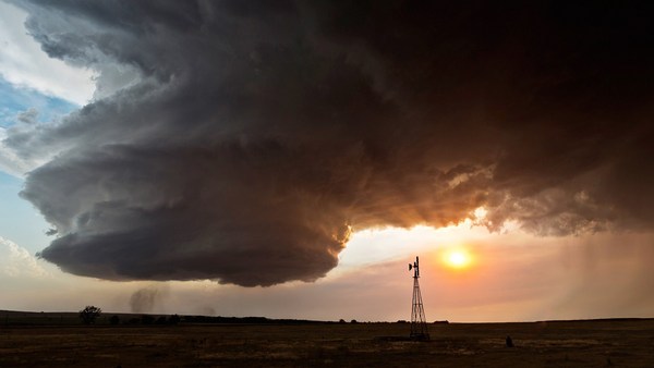
And finally, we produce mobile apps that include narrated virtual tools. The more I got involved in the heritage field, the more it became clear to me that we are losing the sites and the stories faster than we can physically preserve them. Of course, earthquakes and all the natural phenomena -- floods, tornadoes, etc. -- take their toll. However, what occurred to me was human-caused destruction, which was not only causing a significant portion of the destruction, but actually it was accelerating. This includes arson, urban sprawl, acid rain, not to mention terrorism and wars. It was getting more and more apparent that we're fighting a losing battle. We're losing our sites and the stories, and basically we're losing a piece -- and a significant piece -- of our collective memory. Imagine us as a human race not knowing where we came from.
ולבסוף, אנחנו יוצרים אפליקציות לניידים שכוללות כלים וירטואליים בלווי קריינות. ככל שנכנסתי לתחום המורשת, התברר לי שאנחנו מאבדים את האתרים ואת הסיפורים מהר משאנו יכולים לשמר אותם פיסית. כמובן, רעידות אדמה וכל התופעות הטבעיות -- שטפונות, טורנדו, וכו' -- משאירים את חותמם. עם זאת, מה שהובן לי היה ההרס מעשה ידי אדם, שלא רק גרם לחלק משמעותי מההרס, אלא למעשה הוא הואץ. זה כלל הצתות, התפשטות עירונית, גשם חומצי, ושלא נזכיר טרור ומלחמה. זה נעשה יותר ויותר ברור שאנחנו מפסידים בקרב. אנחנו מפסידים את האתרים שלנו והסיפורים, ובעיקרון אנחנו מפסידים פיסה -- ופיסה משמעותית -- מהזיכרון הקולקטיבי שלנו. דמיינו אותנו כמין אנושי שלא יודע מאין הוא הגיע.
Luckily, in the last two or three decades, digital technologies have been developing that have helped us to develop tools that we've brought to bear in the digital preservation, in our digital preservation war. This includes, for example, the 3D laser scanning systems, ever more powerful personal computers, 3D graphics, high-definition digital photography, not to mention the Internet. Because of this accelerated pace of destruction, it became clear to us that we needed to challenge ourselves and our partners to accelerate our work. And we created a project we call the CyArk 500 Challenge -- and that is to digitally preserve 500 World Heritage Sites in five years.
למזלנו, בשניים או שלושה העשורים האחרונים, הטכנולוגיה הדיגיטלית התפתחה ועזרה לנו לפתח כלים שהבאנו לעזור בשימור הדיגיטלי, במלחמת השימור הדיגיטלית. זה כולל, לדוגמה, את מערכות הסריקה התלת מימדיות בלייזר, מחשבים אישיים חזקים יותר, גרפיקה תלת מימדית, צילום דיגיטלי ברזולוציה גבוהה, וכמובן האינטרנט. בגלל קצב ההרס המואץ הזה, נהיה ברור לנו שאנחנו צריכים לאתגר את עצמינו ואת שותפינו להאיץ את העבודה. ויצרנו פרוייקט שקראנו לו אתגר CyArk 500 -- וזה לשמר דיגיטלית 500 אתרי מורשת עולמיים בחמש שנים.
We do have the technology that's scaleable, and our network of global partners has been expanding and can be expanded at a rapid rate, so we're comfortable that this task can be accomplished. However, to me, the 500 is really just the first 500. In order to sustain our work into the future, we use technology centers where we partner with local universities and colleges to take the technology to them, whereby they then can help us with digital preservation of their heritage sites, and at the same time, it gives them the technology to benefit from in the future.
יש לנו את הטכנולוגיה שמאפשרת מדידה, ורשת השותפים העולמית שלנו התרחבה ויכולה להתרחב בקצב גבוה, אז אנחנו די בטוחים שהמשימה הזו יכולה להתגשם. עם זאת, בשבילי, ה 500 הוא בעצם רק ה 500 הראשונים. כדי לשמור את עבודתינו בעתיד, אנחנו משתמשים במרכזים טכנולוגיים בהם אנחנו חוברים לאוניברסיטאות ומכללות מקומיות לקחת את הטכנולוגיה אליהם, כך הם יכולים אז לעזור לנו בשימור דיגיטלי של אתרי המורשת שלהם, ובאותו זמן, זה מאפשר להם להנות מהטכנולוגיה גם בעתיד.
Let me close with another short story. Two years ago, we were approached by a partner of ours to digitally preserve an important heritage site, a UNESCO heritage site in Uganda, the Royal Kasubi Tombs. The work was done successfully in the field, and the data was archived and publicly disseminated through the CyArk website. Last March, we received very sad news. The Royal Tombs had been destroyed by suspected arson. A few days later, we received a call: "Is the data available and can it be used for reconstruction?" Our answer, of course, was yes.
תנו לי לסיים עם סיפור קצר נוסף. לפני שנתיים, שותף שלנו ביקש מאתנו לשמר דיגיטלית אתר מורשת חשוב, אתר מורשת של אונסקו באוגנדה, קברי קסובי הקדושים. העבודה נעשתה בהצלחה בשטח, והמידע אורכב והופץ ציבורית דרך אתר CyArk . במרץ האחרון, קיבלנו חדשות עצובות מאוד. הקברים הקדושים הושמדו בחשד להצתה. מספר ימים לאחר מכן, קיבלנו שיחה: "האם המידע זמין ואפשר להשתמש בו לשחזור?" תשובתנו כמובן היתה כן.
Let me leave you with a final thought. Our heritage is much more than our collective memory -- it's our collective treasure. We owe it to our children, our grandchildren and the generations we will never meet to keep it safe and to pass it along. Thank you.
תנו לי להשאיר אתכם עם מחשבה אחרונה. המורשת שלנו היא הרבה יותר מהזיכרון הקולקטיבי שלנו -- זה האוצר הקולקטיבי שלנו. אנחנו חייבים את זה לילדינו, נכדינו והדורות שלעולם לא נפגוש לשמור עליה ולהעביר אותה. תודה לכם.
(Applause) Thank you.
(מחיאות כפיים) תודה לכם.
Thank you.
תודה לכם.
Thank you.
תודה לכם.
Well, I'm staying here because we wanted to demonstrate to you the power of this technology and so, while I've been speaking, you have been scanned. (Laughter) The two wizards that I have that are behind the curtain will help me bring the results on the screen. (Applause)
ובכן, אני נשאר פה מפני שרצינו להדגים לכם את כוחה של הטכנולוגיה וכך, בזמן שדיברתי, נסרקתם. (צחוק) שני האשפים שאיתי שמאחורי הקלעים יעזרו לי להביא את התוצאות למסך. (מחיאות כפיים)
This is all in 3D and of course you can fly through the cloud of points. You can look at it from on top, from the ceiling. You can look from different vantage points, but I'm going to ask Doug to zoom in on an individual in the crowd, just to show the amount of detail that we can create. So you have been digitally preserved in about four minutes. (Laughter)
זה הכל בתלת מימד וכמובן אתם יכולים לעוף דרך ענן הנקודות. אתם יכולים להביט בו מלמעלה, מהתקרה. אתם יכולים להביט מנקודות שונות, אבל אני אבקש מדאג לעשות זום על אדם בקהל, רק כדי להראות לכם את כמות הפרטים שאנחנו יכולים ליצור. אז נשמרתם דיגיטלית תוך בערך ארבע דקות. (צחוק)
I'd like to thank the wizards here. We were very lucky to have two of our partners participate in this: the Historic Scotland, and the Glasgow School of Art. I'd like to also thank personally the efforts of David Mitchell, who is the Director of Conservation at Historic Scotland. David. (Applause) And Doug Pritchard, who's the Head of Visualization at the Glasgow School of Art. Let's give them a hand.
הייתי רוצה להודות לאשפים פה. היינו ברי מזל שהיו לנו שניים מהשותפים שלנו שהשתתפו בזה: סקוטלנד ההיסטורית, ובית הספר לאמנויות של גלאזגו. הייתי רוצה גם להודות אישית למאמצים של דייוויד מיטצ'ל, שהוא מנהל השימור בסקוטלנד ההיסטורית. דייוויד. (מחיאות כפיים) ודאג פריטצ'ארד, שהוא ראש מחלקת ההדמיה בבית הספר לאמנויות בגלאזגו. תנו להם מחיאות כפיים.
(Applause)
(מחיאות כפיים)
Thank you.
תודה לכם.